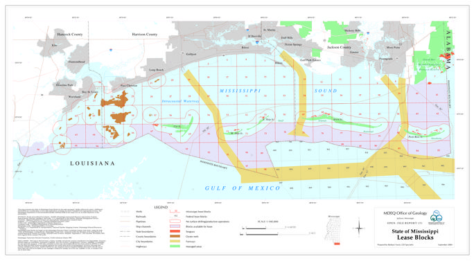
This map presents the State of Mississippi lease blocks for the state-managed, tidally-influenced waters. Additional information for consideration of oil or gas exploration or leasing has been compiled from appropriate sources. The Mississippi Department of Environmental Quality (MDEQ) believes the map to be an accurate depiction of this information. The senate bill No. 2853 prompted the creation of open file report 151 from our office. (https://billstatus.ls.state.ms.us/documents/2004/html/SB/2800-2899/SB2853SG.htm)
The map is 30" x 48".
Mississippi lease blocks are based on the Mississippi Mercator Plane Coordinate System (east zone), using the map "State of Mississippi, Leasing Blocks, Mississippi Sound Area," prepared under the direction of the Department of Natural Resources, Bureau of Geology, Mineral Lease Division, Adopted: September 2, 1969, Revised: November 1985. Each regular block contains 5760 acres.
OF-151 State of Mississippi Lease Blocks
Author(s): Barbara Yassin
Publication Type: Map
Year: 2004
Date: September
Language: English
Series: Open-File Report
Series Number: 151
Publisher: Mississippi Department Of Environmental Quality, Office of Geology
Publisher Location: Jackson, MS
* Physical Copy Price:
$10.00
Additional Costs: $5.00 postage rolled or $2.00 folded
Download (15 MB):
Preview Image: