Mississippi Geochemical Survey
Surface Geochemical Survey of Mississippi
David E. Thompson, RPG
Mississippi Department of Environmental Quality, Office of Geology
The Mississippi Department of Environmental Quality (MDEQ), Office of Geology took part in a cooperative project with the U. S. Geological Survey (USGS) to develop the Mississippi portion of the ongoing National Geochemical Survey. Over a year of planning and training went into the realization of this venture. An additional year was spent in the field engaged with sample collection.
The aspirations of the project were to 1) determine baseline (naturally occurring) values for chemical elements based on stream sediment and soil samples, 2) prepare statistically reliable geochemical maps for individual elements where possible, and 3) identify areas favorable for mineral exploration. This soil and sediment sampling program, the first statewide effort in Mississippi conducted in 1997-1998, produced valuable information in relation to the state’s environmental and mineral characteristics.
What is a Geochemical Survey?
The availability of chemical elements, in acceptable proportions and combinations, plays a vital role in the quality and survival of life. Risk to humans, animals, or plants may exist where certain chemical elements occur in excessive or deficient quantities. Systematic determination of the present abundance and spatial distribution of the elements across the earth’s surface is key to assessing that risk.
The first systematic geochemical survey in the United States was developed by the USGS in 1968. The resulting data set was given the acronym RASS (Rock Analysis Storage System) and included a large quantity of geochemical exploration data garnered nationwide. The RASS geochemical data predominantly comprise analyses of stream sediments and soils from likely uranium-bearing igneous and metamorphic terranes of the “hard rock” west and east, but geochemical analyses of rock, soil, sediments, and occasionally plants were performed for exploration of other metals, such as copper, lead, zinc, and nickel.
The USGS advanced a second geochemical survey, in the early 1970s, termed PLUTO. PLUTO integrated small-scale geochemical survey data gathered by the USGS, and included a sizeable quantity of geochemical analyses from rocks and ores resulting from various USGS peripheral projects (Baedecker and others, 1998).
The National Uranium Resource Evaluation program (NURE) commenced in the mid-1970s. The newly created Department of Energy funded and managed the NURE program. The principal aim of the NURE program was to gather data to evaluate uranium resources for the United States and delineate areas favorable for uranium deposits (Averett, 1984). Additionally, between 1975 and 1983, the NURE program accrued ground-based geochemical data along with airborne spectral gamma-ray radiation data encompassing a large portion of the conterminous 48 states and Alaska.
The Hydrogeochemical Stream Sediment Reconnaissance (HSSR), an element of the NURE program, involved collection and analysis of samples of sediment (stream, soil, talus, playa, and others), ground water, surface water, and vegetation to determine concentrations of uranium and other selected elements (Arendt and others, 1980; Hoffman and Buttleman, 1994). These varied data sets advanced delineation of geochemical provinces and established auspicious locales where further detailed investigation was desirable. Averett (1984) presents tabulations of areas that were surveyed during the HSSR and lists available information for those areas.
Another facet of the NURE program was to utilize aerial gamma-ray surveys. This data set constitutes the only nationwide compilation quantifying natural radiation in the environment. The U.S. Geological Survey has reprocessed the aerial gamma-ray data to produce maps showing surface concentrations of potassium (K), uranium (U), and thorium (Th) for the conterminous United States (Duval and others, 1989, 1990; Phillips and others, 1993).
By the early 1980s the NURE database consisted of 894 files in 49 different formats. To help correct this problem, the University of Oklahoma was funded to compile and synthesize the various formats into one. They were able to combine 817 of the 894 files into one format before funding ran out. So the format problem, while improved, remains an impediment when considering the entire database. Since 1985 the USGS has been the repository for the NURE data, samples, and field maps.
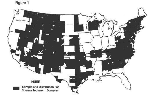
Mississippi was never considered a high priority objective during the course of these earlier geochemical survey efforts, and as a result very little was known about its geochemical characteristics (Figure 1).
Presently, the National Geochemical Data Base includes all of the above data sets, in addition to the recently completed state sampling projects. Sample materials include stream sediment, soil, bedrock, surface water, ground water, and vegetation. With respect to the Mississippi project database, stream sediment sample coverage dominates over other types of sampling, and is generally thought to be the most useful type of sample in assessing mineral resource potential and determining geochemical backgrounds. Stream sediment generally represents a composite of materials shed from upstream areas and, when properly sampled, provides average geochemical signatures derived from rock units and soils within a drainage basin. Ideally, bedrock or mineral specimens of interest could be analyzed to determine a “fingerprint” which might be compared to stream sediment analysis in order to identify terranes which are consistent with a particular mineral deposit type.
Alternatively, soil samples are considered point-source data and are thought to be less useful in determining the overall elemental constituents of an area, but must be utilized in areas where suitable streams do not exist. Nevertheless, soil samples characteristically provide site-specific geochemistry – the type of data most valuable to soil scientists and agricultural stakeholders.
Methods and Techniques
The planning effort for Mississippi identified a preferred sample type and configured the number of samples required for adequate regional coverage. It was decided that stream sediment samples would best characterize the state’s overall geochemical make-up for this initial investigation, except for the “Delta” region, where soil samples were employed due to a lack of suitable streams and associated sediments. The sampling program, to be consistent with existing geochemical data for the Coastal Plain province, and to be managed within fiscal constraints, determined that a 10 km x 10 km grid spacing of sample locations across Mississippi was the optimum sampling objective. This was a convenient grid size since Universal Transverse Mercator (UTM) projection lines provide just such a framework on USGS topographic maps. For Mississippi, each 10 km x 10 km cell was given a unique sample number created from the easting and northing coordinates of the southwestern corner. The target stream population designated first order streams with drainage basins in the range of 2 – 10 square kilometers. Suitable streams within the cells were randomly selected for sampling by a coin toss. The coin toss procedure was as follows: 1) Quarter the cell. 2) Flip a coin to select the northern or southern half. 3) Flip again to select the eastern or western half. 4) Repeat for each cell to be sampled. Furthermore, within that quarter cell randomly selected, the ideal sediment sample should be taken from the upstream side of bridge crossings in order to avoid downstream dumping scenarios.
In the “Delta” region soil samples were also selected within cells randomly, via a series of coin tosses. Most sample locations were situated near roads for convenience, but far enough away to avoid fill material. A minimum of three hand auger samples of the plow zone (upper 22 cm) were taken, about 35 meters apart, in a triangular spacing, and composited. This procedure reduces sampling errors and fosters the development of statistically reliable geochemical maps.
An essential component in collecting a sample that represents the stream’s geochemistry is compositing. Ideally, 6 to 10 depositional zones within a 100-meter-long stream reach containing fine-grained particulate matter at each site are sampled, with the goal being to select depositional zones that represent upstream influences and various flow regimes. This practice reduces the local-scale variability and allows for more accurate representation of the average geochemical values at the site. Keeping sampling error at a minimum improves the likelihood of being able to produce a stable geochemical map. The data can then be used to determine geochemical baselines of statistically known reliability.
The field work associated with this project was carried out by the staff of the MDEQ Office of Geology. Sampling was begun in September of 1997 and continued at a frantic pace through the first week of April of 1998. Field work and sample collection were performed primarily by two individuals of the Office of Geology’s Surface Geology Division – David Thompson and Seth Berman. Several individuals of the Environmental Geology Division also provided much appreciated help in collecting samples, Trey Magee, Archie McKenzie, and Robert Ingram. During this 7-month period, 1,421 samples were collected statewide (Figure 2).
A field sheet was completed for each sample location in order to characterize the setting in a method useful for the project and for future reference. Recorded information includes: geology, latitude/longitude ascertained by global positioning system (GPS), elevation, relief, vegetation, channel width, flood plain width, water depth, water color, stage, flow rate, setting, possible contaminants, and the alkalinity of the stream water, measured with titration test kits and expressed in ppm total alkalinity as calcium carbonate.
After air drying, samples were shipped to the USGS in Denver for processing and chemical analysis (Thompson and others, 1998). Preparation of sediment samples for chemical analysis involved screening of the bulk sediment samples through a 100 mesh (150 micrometer aperture) U.S. Standard stainless steel sieve. The -100 mesh fraction was split into analytical and archival samples. In cases where insufficient -100 mesh fraction was recovered, the sample was recombined and ground by use of a ceramic-lined grinder to pass through the 100 mesh sieve.
Analytical techniques employed on the samples included the following:
- ICP 40. Forty major, minor, and trace elements were determined by ICP-AES
(Induction Coupled Plasma-Atomic Emission Spectroscopy). - ICP 10. Ten elements were determined using ICP-AES.
- Continuous-flow cold vapor atomic absorption spectrometry for the determination of mercury.
- A multi-acid procedure for the determination of arsenic, antimony, and selenium.
- WDXRF – Wavelength Dispersive X-Ray Fluorescence. Approximately half of the Mississippi samples were analyzed by this method.
- INAA – Instrumental Neutron Activation Analysis.
A supplemental suite of stream sediments and soils was collected as part of a joint USGS – Mississippi Office of Geology project (Thompson and others, 1998, 2002). The Mississippi II set is a group of 116 samples, 97 of which are mainly soils collected near the planned Red Hills lignite mine site (Figure 3). The objective of this study was to establish pre-mining geochemical baseline values for the area. Additionally, six stream sediment samples were collected from the “Delta” region. These samples were collected for comparison purposes with the Mississippi I data set, since all of the previous “Delta” samples were soil. The remaining samples collected were re-samples of Mississippi I data set locations, where anomalous or unusual values had been noted. All samples were analyzed by the ICP40, ICP10, As, Se, and Hg methods, and about three quarters were analyzed also by INAA.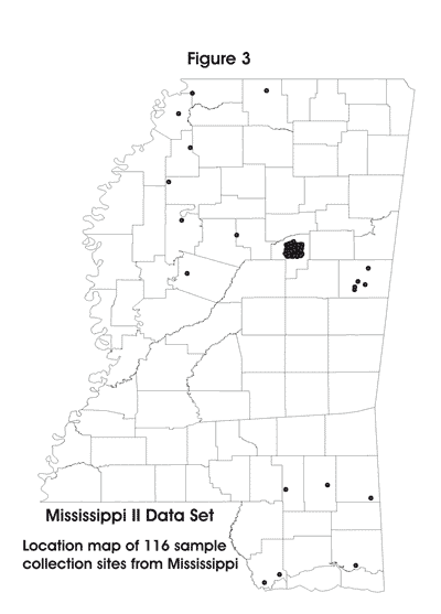
Anticipated Benefits
So what kind of benefits can the State of Mississippi expect to realize from this ambitious project? The Mississippi Office of Geology is contacted frequently by environmental engineering firms and other interested parties requesting data on naturally occurring levels of potentially dangerous chemical elements at specific sites in Mississippi. As Figure 1 illustrates, that type of information has not been available, and only average elemental levels for the southeastern Gulf Coastal Plain at large could be cited. As a result of this effort, geochemical data will be available for small watersheds all across Mississippi.
This type of geochemical data has wide-ranging environmental use. For example, one will be able to consider the natural concentration of lead in sediments of southwestern Noxubee County prior to industrial development, or compare a known mercury-contaminated site in Hinds County to surrounding baseline, naturally occurring levels.
These data will have considerable mineral assessment/exploration potential (for example, Grosz and Schruben, 1994) and will supplement the existing NURE-aeroradiometric coverage. It is anticipated that heavy-mineral bearing (ilmenite, rutile, zircon, and monazite) prospective terranes will be recognized in the Cretaceous and Tertiary outcrop belts in Mississippi, an extension of known prospects in Alabama and Tennessee. A poorly understood thorium-dominated aeroradiometric anomaly associated with the outcrop of the Jackson Group will be investigated. It may represent a previously unrecognized deposit type for placer resources. Additionally, prospective terranes for kaolin, bauxite, and uranium may be recognized as a result of this sampling program. As unusual geochemical situations are identified, it is expected that additional follow-up sampling by the Mississippi Office of Geology will be conducted.
The geochemical data can be utilized to create interpretative derivative maps involving polygons of watersheds, lithology, geology, mineral deposits, land use, and political boundaries.
Data Evaluation
Regarding the nature and distribution of As, Se, Hg, Cu, Pb, and Zn in stream sediments and soils, statistics for stream sediment and soil samples are given below in parts per million. The “Delta” and Black Prairie regions have significantly higher baseline values of these potentially toxic elements with respect to adjacent terranes, in part because soils were the sampled media. A strong spatial correlation is shown to exist between regions of elevated values of these metals and land (broadly) classified as agricultural, irrespective of media sampled. Cretaceous sediments in the State, as throughout the continent, also exhibit higher baseline geochemical values than adjacent geologic units.
| SEDIMENTS | SOILS | |||||
| Min | Median | Max | Min | Median | Max | |
| As | -0.6 | 2.3 | 137 | 1.7 | 8.6 | 27.9 |
| Se | -0.2 | -0.2 | 2.5 | -0.2 | 0.4 | 4.1 |
| Hg | -0.02 | -0.02 | 0.08 | -0.02 | 0.03 | 0.20 |
| Cu | -2 | 3 | 517 | -2 | 10 | 62 |
| Pb | -4 | 13 | 101 | -4 | 17 | 50 |
| Zn | -2 | 14 | 220 | 6 | 49.5 | 222 |
*Links to the results of the geochemical survey are listed below, including the USGS online report of The National Geochemical Survey, Open-File Report 2004-1001. This report provides complete access to NGS data, describes the history of the project, the methodology used, and presents preliminary geochemical maps for all analyzed elements.
To visit the USGS site: The National Geochemical Survey – Database and Documentation, U.S. Geological Survey Open-File Report 2004-1001, Version 1.0, which includes all of the Mississippi data, click here.
Mississippi Data Sets I & II have been extracted from the USGS Open-File Report 2004-1001, click the links below:
To visit Mississippi Geochemical Atlas products, click the following links:
This document is a revision of the Thompson et al. (1998) article published in Mississippi Geology.
References Cited
Arendt, J. W., T. R. Butz, G. W. Cagle, V. E. Kane, and C. E. Nichols, 1980, Hydrogeochemical and stream sediment reconnaissance procedures of the uranium resource evaluation project: U.S. Department of Energy, GJBX-32(80), 53 p.
Averett, W. R., 1984, National uranium resource evaluation guide to data reports of the hydrogeochemical and stream sediment reconnaissance: U.S. Department of Energy, GJBX-5(84), 119 p.
Baedecker, P. A., J. N. Grossman, and K. P. Buttleman, 1998, National geochemical data base: PLUTO geochemical data base for the United States: U.S. Geological Survey,Digital Data Series DDS-47.
Duval, J. S., W. J. Jones, F. R. Riggle, and J. A. Pitkin, 1989, Equivalent uranium map of the conterminous United States: U.S. Geological Survey, Open-File Report 89-478, 10 p., scale 1:2,500,000.
Duval, J. S., W. J. Jones, F. R. Riggle, and J. A. Pitkin, 1990, Potassium and thorium map of the conterminous United States: U.S. Geological Survey, Open-File Report 90-338, 16 p., scale 1:2,500,000.
Grosz, A. E., and P. G. Schruben, 1994, NURE geochemical and geophysical surveys – Defining prospective terranes for United States placer exploration: U.S. Geological Survey, Bulletin 2097, 9 p.
Hoffman, J. D., and Kim Buttleman, 1994, National Geochemical Data Base: National Uranium Resource Evaluation Data for the conterminous United States: U.S. Geological Survey, Digital Data Series DDS-18-A, 1 CD-ROM.
Phillips, J. D., J. S. Duval, and R. A. Ambrosiak, 1993, National Geophysical Data Grids: Gamma-ray, gravity, magnetic, and topographic data for the conterminous United States: U.S. Geological Survey, Digital Series DDS-9, 1 CD-ROM.
Thompson, D. E., A. E. Grosz, J. M. McNeal and J. N. Grossman, 1998, Surface geochemistry of Mississippi to be surveyed: Mississippi Geology, v. 19, no. 2, p. 13-19.
Thompson, D. E., A. E. Grosz, P. G. Schruben and J. N. Grossman, 2002, Solid-phase geochemical survey of the State of Mississippi; on the nature and distribution of As, Se, Hg, Cu, Pb, and Zn in stream sediments and soils [abs.]: Journal of the Mississippi Academy of Sciences, v. 47, no. 1, p. 42.