Fossil Friday
2026
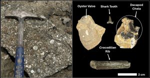 A Variety of Fossil Organisms from a Danian Outcrop in Ripley, MS
 The implications of an American lion fossil discovery for the understanding of Mississippi’s ancient Ice Age landscapes:
The geology of the loess bluffs region of southwest Mississippi has intrigued scientists studying this area for over 200 years. It was not until more intense studies and detailed mapping conducted more recently by our MDEQ State Survey geologists that its secrets were really unlocked. The Mississippi River carved its path deeper into the coastal plain with each cycle of glaciation during the Pleistocene epoch. As glaciers grew up to a mile thick across the North American continent, sea levels fell drastically and the Mississippi River became the main conduit for their meltwaters. The glacial events of the Pleistocene continued for 2.5 million years, leaving behind broad portions of the river’s relic floodplains, called terraces, along its eastern valley wall as the river cut an ever-deeper channel with each glacial cycle.
We broadly classify these ancestral Mississippi River terraces as the Pre-loess Terrace Deposits. The name comes from the fact that they are largely masked by a thick blanket of loess, thick deposits of glacial silt that was windblown off the Mississippi River alluvial plain during the last glacial cycle. Our survey geologists mapped and named the lowest of these terraces the Rodney Terrace. It has been dated to the last glacial maxima, left behind by the river some 20,000 years ago as our modern Mississippi Delta region was being created. The Rodney terrace extends through the southwestern-most part of the bluffline through portions of Jefferson, Adams, and Wilkinson County. It overlooks the river’s modern alluvial plain and is bordered by a succession of older terraces stepping eastward, higher into the bluffs.
These loess terrace planes became deeply dissected by erosion as dendritic stream systems formed across them to drain into the Mississippi River. These terrace planes and the fertile stream valleys that formed on them were home to a diverse array of ice age animals. Many ice age fossils from the Pleistocene epoch have been found in the terrace planes and along the streams that dissect the Mississippi’s loess bluff region.
One of the first vertebrate fossils ever described from Mississippi was the jaw bone of a large extinct predator found on the Rodney Terrace in 1836 near Natchez Mississippi, now known as the American Lion. Its significance wasn’t realized until Joseph Leidy, an early pioneer in paleontology, described it to the Philadelphia Academy of Sciences in 1853 as a giant extinct cat and named it Felis atrox, which is latin for “fearsome cat”. The discovery became so famous that a bronze statue of Dr. Leidy holding the Natchez fossil was erected outside the Academy of Natural Sciences in Philadelphia.
Much more is known about America Lion from subsequent fossil finds throughout other parts of North America. The American Lion is now classified from genetic studies by paleontologists as Panthera atrox because of its relationship to the Eurasian cave Lion. American Lions were significantly larger than modern African lions. They shared the North American landscape with a number of other large predators such as the dire wolf, sabertooth cat, great shortfaced bear, and even our earliest indigenous inhabitants, the ice age hunter-gatherers of the PaleoIndian period.
Surprisingly, there is still very little known about the American Lion here in Mississippi, where it was first discovered and identified. The context of the locality from which the type specimen was collected was never properly documented. Until recently it was believed to have been found along a gravel bar of the Mississippi River where an abundance of other ice age fossils have been discovered over the years. This is where all of the other specimens of American Lion that our survey scientists have been able to document have come from….and there have only been just a handful to date!
Based on preservation characteristics of the Leidy specimen, our state survey scientists now believe that it actually came from the Rodney Terrace and not the gravel bars along the Mississippi River. This is based on studying the distinct preservation details and types of minerals that encrust other ice age fossils of mammoth, mastodon, horse, tapir, ground sloth, and antique bison that have been found on the Rodney Terrace and are different from fossils of the same types of animals found along the Mississippi River. This is an important distinction because ice age fossils found here along the Mississippi River can represent carcasses of animals that traveled a great distance down the river as opposed to living and dying in this specific region. They may not necessarily represent animals that inhabited our Pleistocene environment and the landscapes here in Mississippi but were instead adapted to regions further to the north.
Some solid evidence of the American Lion being part of our Mississippi ice age landscape finally came last week. This came as an amazing discovery made by Kerry Murray in Wilkinson County, Mississippi. Kerry brought his find to the attention of state scientists at the Mississippi Museum of Natural Science where it was properly identified as an exquisitely preserved jaw of an American Lion and the find was also shared with our State Survey scientists. It is one of the more significant ice age finds ever discovered in our state. This is not just because of what animal it belonged to, and the condition it was in, but because of the context in which it was found.
Kerry found his American Lion jaw fossil in a small creek in the loess bluffs and not along a gravel bar of the Mississippi River. This fossil does not share the mineral characteristics of the ice age fossils found on the Rodney Terrace, like the Leidy specimen does. Kerry’s American Lion jaw is typical of the pristine nature of fossil preservation observed in the ancient ice age alluvium of the loess bluffs streams. Kerry sharing his amazing discovery with our state scientists helps us to better understand the antiquity of the alluvium of the loess bluffs streams and the diversity of the animals that once lived alongside them in Wilkinson County. His remarkable find also firmly places the American Lion as a once true inhabitant of our Mississippi ice age landscape during the Pleistocene epoch.
 The Ryan Mann Chalcedony Quad

 Evactinopora Discovery on Pearl River
The wide diversity of marine fossils found in our chert gravel once weathered from ancient Paleozoic marine limestone bedrock deposits up in the mid-continent. They were then deposited down here by streams and rivers with headwaters in the ancient bedrock that drained their way down across Mississippi towards the Gulf of Mexico. Studying the different chert fossils in our various gravel deposits can help us reconstruct the ancient watersheds of major coastal streams, with headwaters in bedrock regions sourced hundreds of miles away.
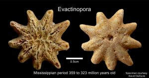
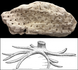
Today’s Fossil Friday brings us one of the most unusual and rare gravel fossils that can be found in our chert gravels. This tiny, distinctively star-shaped marine fossil is only about the size of dime. It was found by 11-year-old future paleontologist David DeGuire while fossil hunting amongst the gravel along a sandbar on the Pearl River just south of Monticello, Mississippi. It was brought to the attention of and properly identified by our MDEQ Mississippi Office of Geology staff.
The fossil is of a unique group of bryozoans called Evactinopora. Bryozoans are colonial animals that filter feed on tiny bits of debris suspended in water. Some colonies are gelatinous and can float, like the ones alive today found in our freshwater ponds and lakes. Many marine bryozoan colonies secrete a stony hard shell, somewhat similar to but unrelated to corals. The individual animals that make up the colony are called zooids, which live in tiny pores in the hard shell. These tiny pores are called zooidal orifices and function somewhat like an apartment complex for the colony.
Marine bryozoan colonies take on many different shapes and modes of life. Many are attached to objects on the sea floor. Some are standalone while others grow to encrust the surface of shells, rocks, and even the surfaces of marine plants and animals. They can be fan-shaped, dome shaped, branching like a tiny tree, or in the case of Evactinopora…star shaped.
Evactinopora is a rare find in our gravels and our scientists first thought they were unusual blastoid fossils. They weren’t properly attributed until more and better-preserved specimens were found. David’s exquisite specimen preserves some incredible detail not seen before by our State Survey scientists in a Mississippi gravel fossil.
Evactinopora lived during a part of the Carboniferous period called the Mississippian. It lived in a tropical shallow ocean between 359 to 323 million years ago. This sea no longer exists today and is now represented by the hard limestone bedrock that makes up a good portion of the North American mid-continent.
The Pearl River where this ancient fossil was found lies between the dividing line of two ancient graveliferous river terraces: The older Magee Terrace on the east side and the younger Brookhaven Terrace on the west side. Both of these terraces belong to an ancestral Mississippi River that was dominated by the influence of the ancient Tennessee and Ohio River systems where the gravel originated. These ancient river systems are dated to the Pliocene epoch, a time just before the ice ages of the Pleistocene epoch.
David’s fossil Evactinopora helps our State Survey scientists to better understand the bedrock influence of this Pre-Pleistocene ancient great river system long before the formation of the modern Mississippi River, which was largely shaped by later glaciations of the Pleistocene epoch.
Fossil Gems in Lauderdale County
 Most people think of fossils as the remains of plants or animals that are preserved in the geologic record by undergoing mineralization and becoming stone. In most scenarios throughout the world this is a correct assumption. But…Mississippi’s marine invertebrate fossil record is unlike most others anywhere else in the world. In many of our different geologic formations throughout the state, marine mollusk shells are preserved as fossils but are not “fossilized”. Because of the rapid deposition and unique geochemistry of the sediments that make up our state, many of the marine mollusk fossils found here still possess their original, unaltered organic shell material. This type of exquisite preservation of the remains of these invertebrate animals gives scientists an opportunity to study our fossil mollusks in great detail and in ways that are not possible with specimens that underwent mineral replacement.
We often like to talk about the amount of information we can get from perfectly preserved shells, such as the organic structures of the animals and the chemical signatures about the environment they once inhabited. Sometimes though, other types of fossil preservation, such as “fossilization” can be just as fascinating to our State Survey scientists.
Today’s Fossil Friday brings us to the middle Eocene of Lauderdale County. The aggressive hills of this area of Mississippi are underlain by the dominantly shallow marine deposits of the Claiborne group, which encompass the time period from approximately 40 to 50 million years ago. Because of the different chemistries of these deposits in the area, some allow for excellent mollusk shell preservation, while in others, the shells have long dissolved away and left behind only their impressions in the rock.
In today’s case, “fossilization” occurred after the original shell material dissolved away, leaving perfect impressions of the shells as voids in the stone. Later, groundwater rich in dissolved silica entered these molds of the shells and precipitated the mineral chalcedony (a form of microcrystalline quartz) to fill the empty voids. This made perfect copies of the shells by creating a mineral “cast” of their impressions in the sediment. Thus, paleontologists call this type of fossilization fossil “molds and casts”.
These beautiful translucent chalcedony fossil shell casts were recently collected by Bubba Eakes in Lauderdale County, MS and brought to the attention of our MDEQ state geological survey scientists for identification here at the Office of Geology. Our Survey scientists were very excited to see this discovery as this type of preservation is not common in our state and is only known from a handful of outcrops in that area, particularly from the Tallahatta and Winona Formations. Because of the excellent details preserved in the chalcedony mineral casts of Bubba’s finds, our survey scientists have tentatively identified one of Bubba’s fossil gastropods down to the species level, Athleta lisbonenesis. The genus Venericardia and Turritella are both known throughout the section of middle Eocene deposits exposed in Lauderdale County, but the fossilized Athleta shell may give us some even better information on the particular geologic formation they came from. The species A. lisbonenesis likely comes from Cook Mountain Formation deposits in the area and this type of mineral fossilization was not previously known from this formation in Mississippi. Additionally, translucent chalcedony of this quality can be considered a semi-precious stone, making these fossils true little gems.
Intriguing Taphonomic Traces on a Proboscidean Rib from Yazoo County
 Loess deposits throughout Mississippi frequently yield fossil remains of animals that thrived during the last glacial maximum, in a period of geologic time called the Pleistocene epoch. Back then, Mississippi was home to a number of giant herbivores including mammoths, mastodons, giant ground sloths, ancient horses, bison, and tapirs. Large predators such as American lions, saber-toothed cats, dire wolves, and short-faced bears also roamed our region. These were not the only predators inhabiting Mississippi’s ancient landscapes – ancestors and relatives of modern Native Americans also inhabited this area at that time, coexisting with these prehistoric mammals. Like other predators, early Native Americans also relied on hunting the megafauna for their survival.
Animal behaviors such as predator-prey interactions and scavenging activity can occasionally be preserved on bones in the fossil record and are just a few examples of taphonomic processes. Taphonomy is the scientific study of all processes that occur to an organism after it dies. This includes things like decay, burial, and preservation in the fossil record, as well as any damage or deformation of the animal’s remains caused by the activity of other organisms.
These processes are frequently observed in both extinct and extant animal remains in Mississippi. Examples of this include fossil bones of marine mammals that exhibit bite marks from feeding by extinct sharks, or the bones from a modern deer carcass that contain gnaw marks left behind by rodents chewing on the bones.
Early Native Americans utilized many components of the animals they hunted. Their harvest was not just a food source – other parts of the animal were used for warmth, dwellings, clothing, tools, and other resources. Direct evidence of early Native American interactions with Pleistocene megafauna are quite rare in the fossil record but sometimes can be observed in artifact assemblages as well as the remains of the animals themselves. Much like how gnaw and bite marks can be preserved on other fossil bones, traces left behind by early Native American tools pre- and post-mortem (before and after the animal’s death) can sometimes be preserved on fossil remains. Examples of this may include traces left behind from tools used during the hunting of an animal or processing and harvesting different components of the animal.
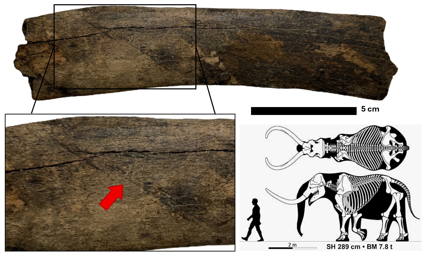
Today’s fossil Friday brings an interesting recent find that may possibly represents an example of such an occurrence. Recently, a fossil rib fragment of a Proboscidean, likely from a mastodon, was brought in to our State Survey scientists at MDEQ’s Office of Geology to investigate. This specimen from Yazoo County was found by William Pettis in a loess bluff stream, where many other ice age fossils have been found over the years.
This rib fragment, though very eroded, still possesses prominent straight, parallel incised marks that extend diagonally across its surface. The orientation of these traces was not suggestive of the typical gnaw patterns that would have been made by rodents or by that of animal predators. We are certain that early Native Americans had interacted with megafauna during this time but evidence of it is scant in both the archaeological and paleontological record of our region. Our Survey scientists could not readily discount the markings as natural so it does beg the question to whether these marks could have been inflicted by anthropogenic (human-based) means.
This is a great example of a very important process scientists must go through when they conduct research on a specimen. They use evidence, deduced by observation, to established information to help form educated guesses that then provide possible explanations for certain observations. These are called hypotheses. Often, there are multiple potential causes for the occurrence of something in nature, and scientists must consider all the different explanations before drawing a conclusions.
In the case of this fossil Proboscidean rib, the possibility that the scratch marks may have been inflicted by humans is quite tantalizing and cannot be fully discounted, but there is not enough sufficient evidence to concretely prove it. Animal remains are subject to erosion and various types of wear from the environment. It is quite possible that these markings on the rib are a result of such natural abrasion from environmental components at some point during or following its fossilization process.
In order to properly conclude whether or not these traces were the cause of ancient human activity, much more scrutiny and research is required. This includes necessary comparisons to other remains with similar natural traces and also to remains with confirmed anthropogenic traces.
Nevertheless, this newly discovered specimen provides an exciting glimpse into the dynamic nature of taphonomic processes preserved in Mississippi’s rich fossil record, the scientific process our Survey Scientists must use in studying fossils, and a possible glimpse into the relationships early Native Americans may have had with Mississippi’s prehistoric life during the last ice age. This specimen has been graciously donated to the State’s vertebrate fossil collections at the Mississippi Museum of Natural Science for further detailed study.
 Baby Mammoth Tooth Discovered in Mississippi
Columbian mammoths (Mammuthus columbi), which were closely related to modern elephants, were open grassland grazers and would have been at home in only a select few environments, particularly in the prairie regions of our state. They played an important role in maintaining the rich fertile ecosystem of our Mississippi’s prairie regions during the Pleistocene epoch along with the plant and animal communities that evolved on it, much as their living elephant relatives do today in other parts of the world. The prairie soils of what is now northeast Mississippi’s black prairie region formed from the erosion of the underlying outcrop belt of the Cretaceous age marine bedrock. The ice-age prairie ecosystem was not only home to the Columbian mammoth, it was also home to other herbivores such as herds of now extinct horses and giant bison along with giant ground sloths, giant tortoises, and tapirs.
Columbian mammoths were much larger than the infamous woolly mammoths that roamed the colder, more northern regions of North America. They were true giants! Columbian mammoths grew up to 15 feet at the shoulder and could weigh over 10 tons. They were also likely less hairy – appearing more like modern elephants. Living in our much warmer southern climate, they really didn’t need the thick coat like their wooly relatives up north.
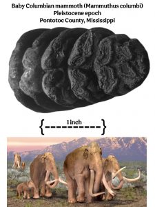
Today’s Fossil Friday brings us an amazing recent discovery made by Roger Rakestraw from near Ecru in Pontotoc County, Mississippi. This rare baby Columbian mammoth tooth was brought to the attention of our MDEQ scientists and identified earlier this week by our MDEQ’s State Geological Survey staff. Our state scientists can tell quite a bit by studying Roger’s extraordinarily rare discovery.
This mammoth “milk tooth” (the first set of molars) only began to erupt around the first year of age. These first teeth are typically lost and replaced by a second set shortly after weaning at around age three. Similar to modern elephants, mammoth had six sets of molar teeth throughout their lives. They only use four molars at once (two on top and two on bottom) and their molars erupted sequentially. As a mammoth grew, molars wore down from the tough grasses it ate and the old sets fell out and were replaced by new ones erupting from behind in the mouth. Mammoths likely lived for between 60 to 70 years of age with their final, sixth set molars arriving about age 30. If this final set wore down, the mammoth could no longer chew. This typically caused the animal to starve to death.
Roger’s baby mammoth tooth was from a juvenile that was only around one year of age before it died. Our scientists can tell that, because there is only wear on a small portion of this fossil tooth with not much of it having even erupted into the jaw yet. The environment of the Pleistocene ice age prairie was a dangerous place for a baby mammoth, being under foot of much larger individuals in the heard as it roamed the grasslands and even adult male elephants being known to attack and kill juvenile elephants. The prairie was also home to a number of formidable ice age predators such as dire wolves, saber toothed cats, American lions, and even the earliest indigenous human inhabitants of our region that would have seen a baby mammoth as easy prey.
Though we don’t know how this baby mammoth ultimately came to its demise, this rare and amazing fossil find offers our state and its scientists a rare window into its life during the Pleistocene epoch and the ancient prairie region of the northeastern Mississippi that once was its home.
From Ancient Oceans to the Mississippi River
 Gastropods, commonly known as snails and slugs, belong to the biological class Mollusca, which is the second largest class of animals only outnumbered by insects. With an estimated number of 80,000 species alive today, gastropods are the only members of class Mollusca that have evolved to breathe both in the water and on land. They can therefore inhabit just about every environment imaginable on our planet. They can be found in your backyard garden, streams and lakes, and even incredibly hostile environments like deserts and deep-sea hydrothermal vents in the world’s deepest oceans.
The earliest known gastropods begin to show up in the fossil record during the Cambrian period. Throughout much of the Paleozoic era they were far less common than their cousins, the pelecypods, or bivalves, which include animals such as clams, mussels, scallops, shipworms, and oysters. By the Carboniferous period, gastropods were still primitive and mostly aquatic but inhabited more diverse environments. Their shells also began to resemble some of the more familiar basic forms that we see today.
It was during the Mesozoic era that the ancestors of most modern gastropods evolved. Their fossils sometimes dominate sediments in the rock record, particularly in marine environments, and by the Cretaceous period, land-dwelling gastropod fossils also become more common.
Gastropods survived the major extinction event at the close of the Cretaceous period. They played a major role in the recovery of our planet after 75 percent of all life was lost. Here in Mississippi, the early Paleocene Clayton Formation has beds that are almost exclusively made up of fossil shells of shallow marine gastropods belonging to the genus Turritella.
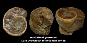
Today’s Fossil Friday brings us a specimen of an extremely ancient fossil specimen from Mississippi: an archaeogastropod found by Laura Sanford on Island 62 on a gravel bar of the Mississippi River. It was brought into this year’s annual Fossil Road Show at the Mississippi Museum of Natural Science last month and identified by MDEQ Mississippi Office of Geology scientists.
This rare fossil preserved in chert gravel is from a Macluritoid gastropod which lived during the late Ordovician to Devonian period. The genus Maclurites was the largest gastropod of the Paleozoic Era, attaining a diameter of up to 25 centimeters. Her fossil eroded from Paleozoic bedrock up in the mid-continent and was transported by rivers to Mississippi, where it was then incorporated in the gravel of the stream’s alluvium along the Mississippi River on its journey to the Gulf of Mexico.
Fossil Friday is making waves… and teeth the size of your hand.
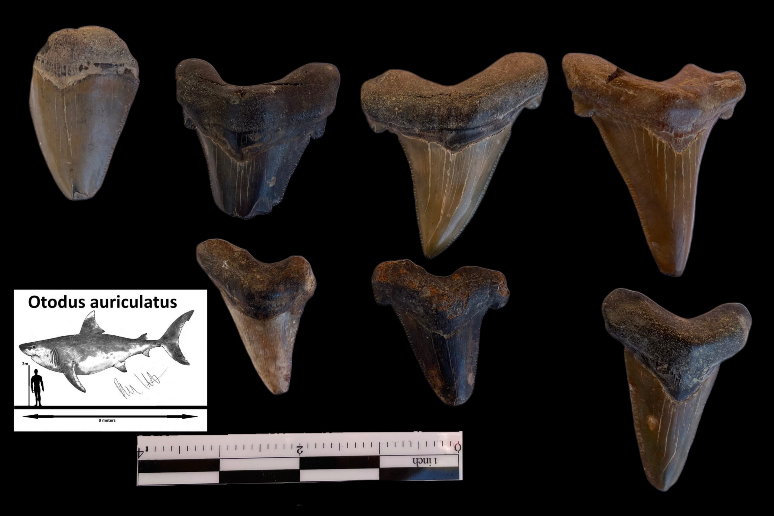 One of the largest mega-toothed sharks to inhabit the world’s oceans was called Otodus auriculatus. It once lived here in Mississippi during the later part of Eocene epoch and the early part of the Oligocene epoch, a time that spanned between 38 and 30 million years ago.
During the late Eocene, the earth was quite warm compared to today and much of Mississippi was covered by ocean waters. These giant sharks were not alone hunting the depths of the oceans in what are now the marine deposits of the Jackson Group. Otodus auriculatus competed directly with a variety of ferocious toothed whales, called Archaeocetes. These primitive whales ranged in size from the small Durodon and Zyghoriza (16 to 20 feet in length), to the largest predator alive on the planet at that time, Basilosaurus (reaching upwards of 70 feet in length).
Otodus articulates grew to lengths of over 30 feet and may have weighed upwards of two tons. Their distinctive wide, triangular teeth have been found to reach up to 5 inches in length. O. auriculatus have strongly serrated teeth and possess accessory cusps on either side of the large tooth, which are features that set it apart from its largest cousin Otodus megalodon, which lived during the Miocene epoch.
Major climatic shifts occurred going from the Eocene into the Oligocene as the earth began to cool. These giant seas shallowed but still covered parts of the southern half of the state. It is during this period of climatic transition that the limestones of the Vicksburg Group were being deposited. The great Archaeocete whales had vanished and Otodus auriculatus now had no direct competition. Other marine mammals such as Sirenians (relatives of modern dugongs and manatees) were also now more abundant for O. auriculatus to feed on.
This week’s Fossil Friday brings us to a collection of Otodus auriculatus teeth from the Early Oligocene Mint Springs Formation member of the Vicksburg Group in Rankin County. They were collected by the land owner, John Sullivan, over a number of years of him searching for shark teeth and other fossils on his property. They were photographed by MDEQ’s Surface Geology staff while working with landowners during field mapping exercises for this year’s USGS cooperative StateMap detailed geologic mapping grant projects. The limestones of the Vicksburg group and the fossils they contain are important markers at the surface and subsurface for our MDEQ State Survey geologists conducting geologic mapping in south Mississippi.
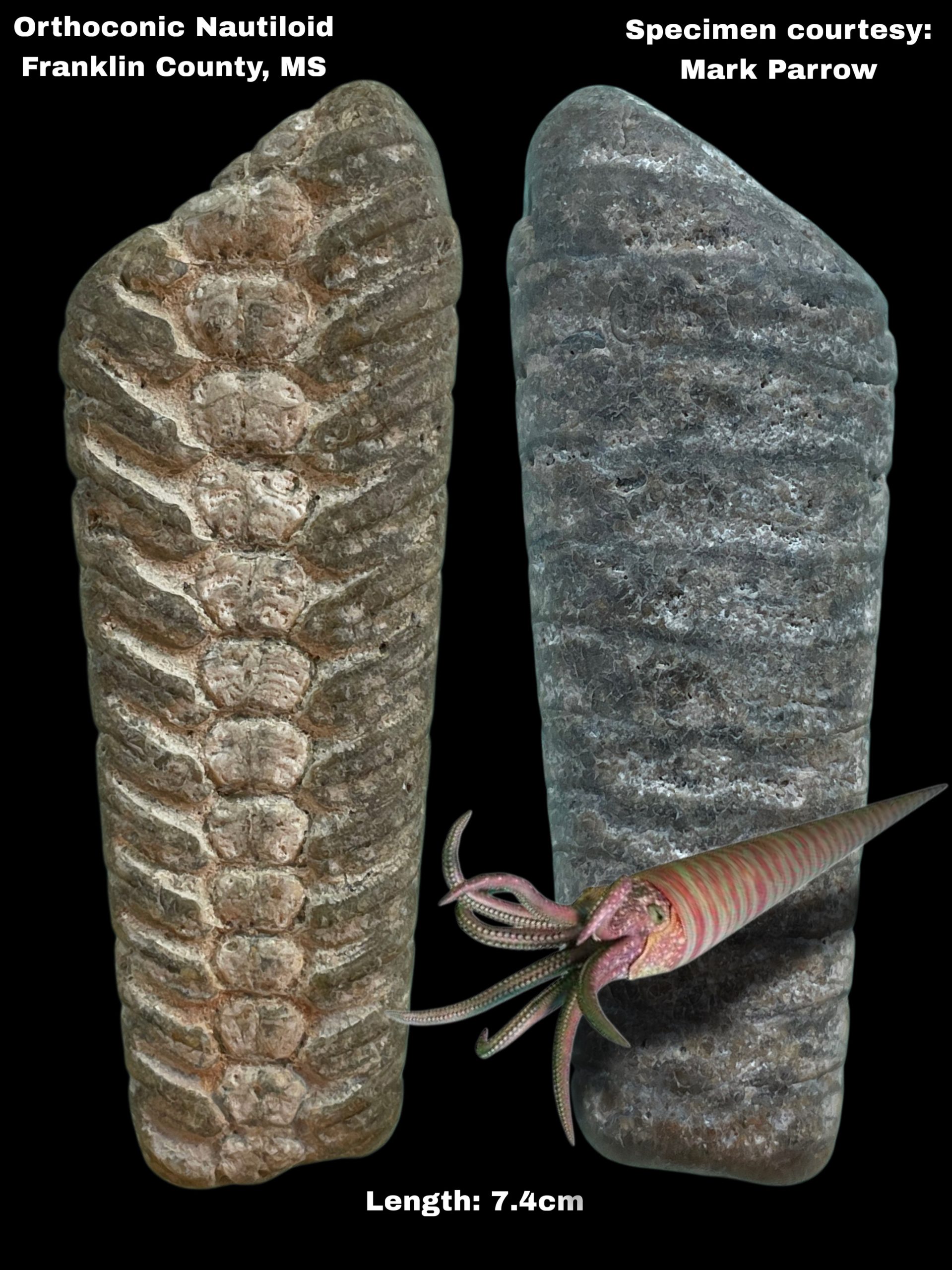
Discovery of an Extremely Well Preserved Orthoconic Nautiloid Fossil
 Fossils can be found just about anywhere in Mississippi. They are the clues that help our scientists decode and reconstruct past worlds that are recorded in our state’s remarkable geology. Fossils come in many forms such as animal bones, shells, and teeth, or as traces such as burrows and footprints. Plant fossils such as petrified wood, leaves, and even fossil pollen are also common throughout Mississippi’s geology.
In most instances, fossils can help tell the age of the deposits in which they are found. But in some cases, fossils can become reworked into younger deposits. That is the case for the fossils commonly found in our State’s chert gravels.
A diversity of well-preserved remains of marine invertebrates such as corals, brachiopods, snails, and even cephalopods can be found throughout our gravel deposits. Their abundance in Mississippi makes them ideal for casual fossil hunting in the gravels of our many streams, as well as gravel driveways, parking lots and even playgrounds.
The fossils contained in our chert gravel are incredibly ancient, especially compared to the natural deposits they are found in. The gravel fossils themselves are actually hundreds of millions of years old, dating back to Paleozoic era. This was long before the days of the dinosaurs. Most of our geologic deposits containing these fossiliferous chert gravels are only a few million to a few thousand years old, dating from the late Oligocene to the late Pleistocene, but older deposits in northeast Mississippi contain Paleozoic chert gravels dating to the late Cretaceous period.
Today’s Fossil Friday takes us to the Homochitto River watershed in Franklin County, Mississippi. This part of Southwest Mississippi is well known for its rich diversity of chert gravel fossils along with other wonderful natural treasures such as banded agates. The Homochitto River watershed drains the gravels of the Pliocene Brookhaven Terrace to the east and the mid-Pleistocene ancestral Mississippi River Pre-loess Terrace deposits to the west which occupy the uplands of the region.
Orthoconic nautiloids were likely fast swimmers who used water jet propulsion to move both backwards and forwards. Some species grew to enormous sizes. They used the chambers in their shells to quickly alter their buoyancy in the water column. They were likely ferocious predators, hunting prey such as crustaceans and early types of fish with their strong sucker-lined tentacles and sharp beaked mouths.
Rare Soft Tissue Preservation of Extinct Clams
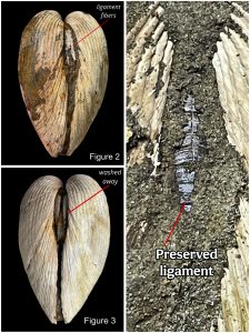 By studying fossils and the sediments that contain them, we can learn a great deal about earth’s history and how life on this planet has changed over geologic time. Fossils are Earth’s record of its diversity of life over the hundreds of millions of years life has existed on this planet. This record is actually quite incomplete because of several geologic processes and factors. Sediment chemistry is not always conducive to fossil preservation before the biological materials rot away. Also, many gaps in time remain because sediments were either not being deposited in certain environments or later eroded away. Therefore, sometimes there is not enough remaining or available geologic material to sustain fossil preservation.
Mastodon Tusk and Tooth Fragments from Jefferson County, MS
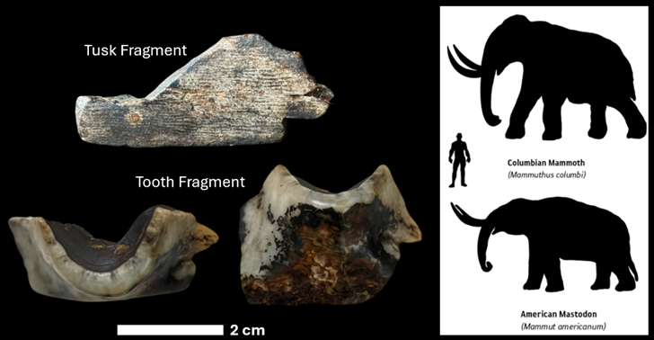 For today’s fossil Friday we are returning to the late Pleistocene at the height of the last glacial maximum, between about 110,000 and 11,700 years ago, and featuring two fossil fragments that belonged to an American mastodon: one of a tusk, and one of a tooth.
Mississippi’s Petrified Wood
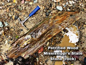 Petrified wood, also known as silicified wood, is our state’s official state stone/rock. So how does ordinary wood, from a once living tree, petrify (turn to stone) to become a fossil? This discussion brings up geochemistry, a topic fundamental to interpreting Mississippi’s geologic record.
 A Treasure Trove from the Ice Age
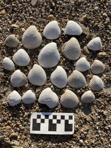 For the many artifact and fossil hunters that explore the gravel bars of the Mississippi River during the yearly seasonal low water levels of the fall and winter, the seemingly endless sea of gravel exposed along the riverbed contains a treasure trove of ice age mammal fossil bones and ancient artifacts. For scientists, this provides a unique window into the lives of ancient humans and other animals that called the great river’s alluvial plain home for tens of thousands of years.
Studying the great variety of different rocks on gravel bars reveals secrets of the Mississippi River’s massive watershed. Each individual rock tells a story about the geology that the watershed encountered and then carried with it as part of the River’s bedload. Things like granite from the ancient bedrock of the Canadian Shield, Sioux Quartzite from the Dakotas/Minnesota area, Lake Superior agates from the Great Lakes region, Stromatoporoid fossils from Ohio Valley and other Paleozoic-era fossils from the mid-continent, and rhyolite from the St. Francois Mountain region of the Missouri River watershed are all common finds along the big river’s gravel bars.
In some places along the gravel bars the river gives clues about the underlying geology directly beneath the river in the form of fossils. The Mississippi River’s alluvium is more than 100 feet thick in most places across the Mississippi Delta region of northwest Mississippi. The underlying Coastal Plain geology is typically only exposed where the river cuts into its eastern valley wall in places like Vicksburg, Grand Gulf, and Natchez. In other places the river cuts deep into the underlying Coastal Plain geology and exposes fossils from the geologic formation below.
Today’s Fossil Friday brings us a collection of marine mollusk shells of an extinct genus of clam called Venericardia, a Late Eocene-aged fossil collected earlier this month by Anna Reginelli from a gravel bar along the Mississippi River in Bolivar County, Mississippi. These robust, heavily ribbed shells are from an ancient shallow sea, called the Jackson Sea, that once covered much of Mississippi nearly 40 million years ago. The presence of these seashells is very important to our State Survey geologists with MDEQ’s Mississippi Office of Geology conducting geologic mapping. These shells belong particularly to the Moodys Branch Formation of the Jackson Group. Other marine fossils such as shark teeth and even fossil bones of our State Fossil, the archaeocete whale, can be found on the Mississippi River gravel bars in the area where these ancient Venericardia fossil seashells were found.
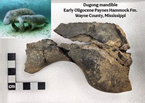 Mississippi Dugongs
Dugongs are sirenians, a group of marine aquatic mammals that also include manatees and sea cows. Dugongs currently only inhabit the warm ocean waters of the Indo-West Pacific. They also once called the warm shallow waters of the northern Gulf of Mexico home during the Oligocene epoch, some 34 to 24 million years ago. Their remains can be found throughout Oligocene-aged limestone beds in south-central Mississippi.
In Mississippi, dugong fossils are particularly known from the preservation of their ribs. These heavy, dense rib bones acted as ballast to the abdomen of the animal while it swam and fed on vast meadows of seagrass in the shallow Gulf Coast waters.
Last October, a team of MDEQ State Survey Geologists and conservation biologists and educators from the Mississippi Museum of Natural Science were working fossil sites along the Chickasawhay River in southeast Mississippi. The natural piles of limestone and sandstone boulders which outcrop along the river channel provided an excellent outdoor classroom to teach our state’s scientists and educators about our rich geological heritage.
While the crew of scientists combed the boulder piles along a large slump block of Paynes Hammock Limestone for fossils in the Chickasawhay River channel, Katie Tupy, the educational director at the Mississippi Museum of Natural Science, found an unusual fragment of fossil bone and brought it to the attention of the MDEQ State Survey Geologist leading the expedition. Bones from large extinct terrestrial mammals, such as the large hornless rhinoceros Subhyracodon and the “hell pig” Entelodon, have been described by our state scientists from the area, but it wasn’t clear yet from Katie’s initial find what animal the fossil bone could be attributed to, and whether it had been terrestrial or aquatic. The break in the bone appeared to be fresh so the search was on to see if the rest of it could be found. The State Survey geologists quickly identified more associated bone fragments embedded in the rock nearby. James Hill, the exhibits director at the Mississippi Museum of Natural Science, helped to carefully excavate the remaining bone from the rock while photographs and measurements of the fossil were taken. Upon returning home that evening, MDEQ geologists carefully examined the field photos and measurements of the fossil and were able to determine that it was a mandible belonging to a dugong and not a terrestrial mammal. Unlike the dense dugong ribs, most other elements of dugong skeletons do not preserve well in the fossil record. This makes this recent fossil discovery by the team a significant find!
While feeding in the protection of sea grass meadows in the warm shallow waters of the Gulf during the Oligocene epoch, the docile dugong were relatively safe from predators. When they migrated out into open tropical waters, they became highly vulnerable to attacks by large sharks including the giant weasel shark, Hemipristis serra and the mega-toothed giant, Otodus auriculatus (the precursor to the infamous O. megalodon). Because of this, most dugong fossils found here are typically isolated bones ravaged with shark bite marks.
In the months following the discovery, George Phillips, the curator of paleontology at the Mississippi Museum of Natural Science, carefully cleaned, preserved, reconstructed, and photographed the dugong mandible specimen for curation and study. It is now housed in the state’s paleontological collections at the museum.
Stigmaria from the Loess Bluffs Region
For today’s Fossil Friday, we are revisiting a fossil donated to the MDEQ by Jeff McCraw, who originally collected it back in 2020 from the Loess Bluffs region in Mississippi.
This large sandstone clast contains an impression of a fossil tree root called Stigmaria. Stigmaria is what is known as a form genus, which is a genus that is described for a specific part of an organism rather than the entire organism itself. This commonly occurs with plant remains since they tend to fossilize as individual components found separate from each other, so these different structures are assigned their own names. Stigmaria refers to root systems of ancient lycopod, or “scale” trees. Examples of these extinct trees include Lepidodendron and Sigillaria.
Lycopods existed during a period of geologic time called the Carboniferous, between about 363 and 290 million years ago. Thick forests and swamps were prolific across much of Earth during this time, ultimately leading to the formation of distinctive massive coal beds associated with Carboniferous-aged rock layers.
Lycopod trees were uniquely adapted to thrive in these wet, swampy conditions. They had shallow, root systems that branched horizontally outward from the trunk. These roots also had tissues called aerenchymatous tissues, which were specialized tissues containing air chambers. These allowed them to function in the low-oxygen conditions of underwater substrates, which are common features of swamp environments.
The sandstone clast bearing this root impression was eroded from mid-continental bedrock and was transported and eventually deposited by the ancestral Mississippi river during the Pleistocene. This fossil serves as both a glimpse into some of the continent’s earliest terrestrial ecosystems, as well as the shifting bedrock sources that contributed to Mississippi’s ancestral river system millions of years later during the last glacial maxima, before the Mississippi river cut down to where it flows in the present.
2025
Rare Soft Tissue Preservation of Extinct Clams
By studying fossils and the sediments that contain them, we can learn a great deal about earth’s history and how life on this planet has changed over geologic time. Fossils are Earth’s record of its diversity of life over the hundreds of millions of years life has existed on this planet. This record is actually quite incomplete because of several geologic processes and factors. Sediment chemistry is not always conducive to fossil preservation before the biological materials rot away. Also, many gaps in time remain because sediments were either not being deposited in certain environments or later eroded away. Therefore, sometimes there is not enough remaining or available geologic material to sustain fossil preservation.
Mastodon Tusk and Tooth Fragments from Jefferson County, MS
For today’s fossil Friday we are returning to the late Pleistocene at the height of the last glacial maximum, between about 110,000 and 11,700 years ago, and featuring two fossil fragments that belonged to an American mastodon: one of a tusk, and one of a tooth.Mississippi’s Petrified Wood
Petrified wood, also known as silicified wood, is our state’s official state stone/rock. So how does ordinary wood, from a once living tree, petrify (turn to stone) to become a fossil? This discussion brings up geochemistry, a topic fundamental to interpreting Mississippi’s geologic record. A Treasure Trove from the Ice Age
For the many artifact and fossil hunters that explore the gravel bars of the Mississippi River during the yearly seasonal low water levels of the fall and winter, the seemingly endless sea of gravel exposed along the riverbed contains a treasure trove of ice age mammal fossil bones and ancient artifacts. For scientists, this provides a unique window into the lives of ancient humans and other animals that called the great river’s alluvial plain home for tens of thousands of years.
Studying the great variety of different rocks on gravel bars reveals secrets of the Mississippi River’s massive watershed. Each individual rock tells a story about the geology that the watershed encountered and then carried with it as part of the River’s bedload. Things like granite from the ancient bedrock of the Canadian Shield, Sioux Quartzite from the Dakotas/Minnesota area, Lake Superior agates from the Great Lakes region, Stromatoporoid fossils from Ohio Valley and other Paleozoic-era fossils from the mid-continent, and rhyolite from the St. Francois Mountain region of the Missouri River watershed are all common finds along the big river’s gravel bars.
In some places along the gravel bars the river gives clues about the underlying geology directly beneath the river in the form of fossils. The Mississippi River’s alluvium is more than 100 feet thick in most places across the Mississippi Delta region of northwest Mississippi. The underlying Coastal Plain geology is typically only exposed where the river cuts into its eastern valley wall in places like Vicksburg, Grand Gulf, and Natchez. In other places the river cuts deep into the underlying Coastal Plain geology and exposes fossils from the geologic formation below.
Today’s Fossil Friday brings us a collection of marine mollusk shells of an extinct genus of clam called Venericardia, a Late Eocene-aged fossil collected earlier this month by Anna Reginelli from a gravel bar along the Mississippi River in Bolivar County, Mississippi. These robust, heavily ribbed shells are from an ancient shallow sea, called the Jackson Sea, that once covered much of Mississippi nearly 40 million years ago. The presence of these seashells is very important to our State Survey geologists with MDEQ’s Mississippi Office of Geology conducting geologic mapping. These shells belong particularly to the Moodys Branch Formation of the Jackson Group. Other marine fossils such as shark teeth and even fossil bones of our State Fossil, the archaeocete whale, can be found on the Mississippi River gravel bars in the area where these ancient Venericardia fossil seashells were found.
Mississippi Dugongs
Dugongs are sirenians, a group of marine aquatic mammals that also include manatees and sea cows. Dugongs currently only inhabit the warm ocean waters of the Indo-West Pacific. They also once called the warm shallow waters of the northern Gulf of Mexico home during the Oligocene epoch, some 34 to 24 million years ago. Their remains can be found throughout Oligocene-aged limestone beds in south-central Mississippi.
In Mississippi, dugong fossils are particularly known from the preservation of their ribs. These heavy, dense rib bones acted as ballast to the abdomen of the animal while it swam and fed on vast meadows of seagrass in the shallow Gulf Coast waters.
Last October, a team of MDEQ State Survey Geologists and conservation biologists and educators from the Mississippi Museum of Natural Science were working fossil sites along the Chickasawhay River in southeast Mississippi. The natural piles of limestone and sandstone boulders which outcrop along the river channel provided an excellent outdoor classroom to teach our state’s scientists and educators about our rich geological heritage.
While the crew of scientists combed the boulder piles along a large slump block of Paynes Hammock Limestone for fossils in the Chickasawhay River channel, Katie Tupy, the educational director at the Mississippi Museum of Natural Science, found an unusual fragment of fossil bone and brought it to the attention of the MDEQ State Survey Geologist leading the expedition. Bones from large extinct terrestrial mammals, such as the large hornless rhinoceros Subhyracodon and the “hell pig” Entelodon, have been described by our state scientists from the area, but it wasn’t clear yet from Katie’s initial find what animal the fossil bone could be attributed to, and whether it had been terrestrial or aquatic. The break in the bone appeared to be fresh so the search was on to see if the rest of it could be found. The State Survey geologists quickly identified more associated bone fragments embedded in the rock nearby. James Hill, the exhibits director at the Mississippi Museum of Natural Science, helped to carefully excavate the remaining bone from the rock while photographs and measurements of the fossil were taken. Upon returning home that evening, MDEQ geologists carefully examined the field photos and measurements of the fossil and were able to determine that it was a mandible belonging to a dugong and not a terrestrial mammal. Unlike the dense dugong ribs, most other elements of dugong skeletons do not preserve well in the fossil record. This makes this recent fossil discovery by the team a significant find!
While feeding in the protection of sea grass meadows in the warm shallow waters of the Gulf during the Oligocene epoch, the docile dugong were relatively safe from predators. When they migrated out into open tropical waters, they became highly vulnerable to attacks by large sharks including the giant weasel shark, Hemipristis serra and the mega-toothed giant, Otodus auriculatus (the precursor to the infamous O. megalodon). Because of this, most dugong fossils found here are typically isolated bones ravaged with shark bite marks.
In the months following the discovery, George Phillips, the curator of paleontology at the Mississippi Museum of Natural Science, carefully cleaned, preserved, reconstructed, and photographed the dugong mandible specimen for curation and study. It is now housed in the state’s paleontological collections at the museum.
Stigmaria from the Loess Bluffs Region
For today’s Fossil Friday, we are revisiting a fossil donated to the MDEQ by Jeff McCraw, who originally collected it back in 2020 from the Loess Bluffs region in Mississippi.
This large sandstone clast contains an impression of a fossil tree root called Stigmaria. Stigmaria is what is known as a form genus, which is a genus that is described for a specific part of an organism rather than the entire organism itself. This commonly occurs with plant remains since they tend to fossilize as individual components found separate from each other, so these different structures are assigned their own names. Stigmaria refers to root systems of ancient lycopod, or “scale” trees. Examples of these extinct trees include Lepidodendron and Sigillaria.
Lycopods existed during a period of geologic time called the Carboniferous, between about 363 and 290 million years ago. Thick forests and swamps were prolific across much of Earth during this time, ultimately leading to the formation of distinctive massive coal beds associated with Carboniferous-aged rock layers.
Lycopod trees were uniquely adapted to thrive in these wet, swampy conditions. They had shallow, root systems that branched horizontally outward from the trunk. These roots also had tissues called aerenchymatous tissues, which were specialized tissues containing air chambers. These allowed them to function in the low-oxygen conditions of underwater substrates, which are common features of swamp environments.
The sandstone clast bearing this root impression was eroded from mid-continental bedrock and was transported and eventually deposited by the ancestral Mississippi river during the Pleistocene. This fossil serves as both a glimpse into some of the continent’s earliest terrestrial ecosystems, as well as the shifting bedrock sources that contributed to Mississippi’s ancestral river system millions of years later during the last glacial maxima, before the Mississippi river cut down to where it flows in the present.
 Fossil Black Bear Tooth from Jefferson County, Mississippi

For today’s fossil Friday, we are featuring another fossil collected from the Loess Bluffs region by MDEQ state survey scientists and National Parks Service Historian Dr. David Slay while on a joint field excursion along Blue Skin Creek in Jefferson County last month. The loess outcrops and stream alluvium in this area frequently yield fossils of many extinct – and some extant – plant and animal remains dating back to the Pleistocene (some 20,000 years old). This geologically significant area contains an uninterrupted stratigraphic section of ancestral Mississippi River Pre-Loess terrace deposits known as the Rodney Terrace, blanketed by glacial silt deposits called Loess. This loess entombs paleosols and clays which comprised the floodplain of the ancestral Mississippi River during the last interglacial stage of the Pleistocene epoch.
Today we are featuring a fossilized tooth of a Black Bear (Ursus americanus), an example of fossilized remains of extant organisms. The presence of black bears in the fossil record dates back to the late Pliocene (some 2.6 million years ago). During the Pleistocene epoch, when the Earth was going through some of its last few and most severe ice ages, they coexisted with other megafauna that populated the region, including saber toothed cats, dire wolves, mammoths, mastodons, and giant ground sloths. Modern day bears are some of the few megafauna that survived the mass extinctions at the end of the Pleistocene.
Nowadays, there are three main species of bears in North America: the Black Bear, the Grizzly Bear, and the Polar Bear. Black Bears have the widest geographic distribution of any other bear species in North America and are the only bears that live in Mississippi. The American Black Bear (Ursus americanus americanus) primarily inhabits Northern Mississippi, and the Louisiana Black Bear (Ursus americanus luteolus) inhabits the southern two-thirds of the state. But during the Pleistocene, black bears were just some of the many species of bears and bear relatives that populated the region. Among these were the giant short-faced bear (Arctodus simus) and the Florida spectacled bear (Tremarctos floridanus). Giant short-faced bears were massive apex predators, standing over 11 feet tall. Florida spectacled bears were much smaller, similar in size to modern black bears, and were closely related to the Andean bear (Tremarctos ornatus), which is still alive in South America today.
Black Bears have been ecologically versatile and adaptable to climatic variation, traits that likely helped their species survive well into the Holocene (our current geologic epoch). Today they serve as important members of the many diverse ecosystems they inhabit, from bottomland hardwood forests and mountains to wetlands and swamps.
 Demopolis Chalk

The Demopolis Formation outcrops in an arcuate belt across northeast Mississippi from the Tennessee line in Alcorn County southeast through portions of Prentiss, Union, Lee, Pontotoc, Chickasaw, Monroe, Clay, Oktibbeha, Lowndes, Noxubee, and Kemper counties. It is an exceptionally pure limestone deposit that is commonly referred to as the “Demopolis Chalk”.
The chalk was deposited in an open marine environment and is made up of a fine-grained sediment that was formed on the sea floor from the calcium carbonate skeletons of numerous tiny single-celled organisms. In particular, the chalk is dominated by the microscopic fossils of single-celled, photosynthesizing marine algae, called coccolithophores, that are covered in a shell of calcium carbonate plates called coccoliths.
The Demopolis Chalk was deposited during the Late Campanian and Early Maastrichtian ages during the later part of the Cretaceous period of the Mesozoic era. This was the bottom of a shallow sea that covered Mississippi during the last days of the dinosaurs. Dinosaur fossils have been found in the Demopolis Chalk but represent land animal carcasses that were swept out to into the open sea by storm surges or swollen rivers.
Vertebrate fossils of marine creatures are quite common throughout the Demopolis formation, and include the teeth and skeletons of predatory fish such as Encodus and Xiphactinus, sharks such as Squalicorax, large marine turtles such as Archelon; and marine reptiles such as plesiosaurs and mosasaurs. Even the fossil remains of pterosaurs, flying reptiles that hunted fish from the skies above the ancient sea, have been found in the Demopolis Formation in Mississippi.
The fossils most commonly found in the Demopolis Chalk are the shells of mollusks that lived along the sea floor, particularly the shells of pelecypods, such as the large oysters Exogyra and Pycnodonte that formed patchy reef like colonies in the muddy chalk sediments.
Today’s Fossil Friday takes us to an outcrop of the Demopolis Formation along Highway 22, just outside of Tupelo in Lee County, Mississippi. Here our MDEQ, State Geological Survey scientists found and sampled fossil along road cuts during routine field work earlier this Fall where they collected specimens of the much smaller oyster, Arctostrea falcata. These very delicate-shelled and unusually arc-shaped oysters remained perfectly preserved in the chalk, many of them with their valves articulated just as they were in life, some 75 million years ago before getting buried and becoming part of our state’s fossil record.
Fossil shells of Arctostrea display examples of many different adaptations oysters evolved to live on the soft, chalky sea bottom. While many shells of Arctostrea are found as dissociated or articulated shells within the chalk, many are also found attached, or cemented, to shells of other Arctostrea or other pelecypods. This is because oyster larvae need to attach to hard substrates for support during their early stages of growth. Some remain attached their entire lives, while others, like Arctostrea, could detach once they were more mature and live out the remainder of their lives on the seafloor.
Arctostrea are examples of oysters with an adaptation sometimes referred to as the “snowshoe” adaptation, in which their shells grow relatively thin and flat, making them lightweight and enabling them to occupy a wide surface area. This prevents them from sinking below the soft sediments, and allows their upper shell, or valve, to remain in contact with the sediment-water interface so they can filter necessary nutrients and dissolved oxygen from the water.
Arctostrea are just a few of the many fossil bivalves that offer glimpses into the diverse benthic ecosystems that thrived in Mississippi’s ancient past. For hundreds of millions of years, oysters and other bivalves have played a vital role in both marine and freshwater environments. In addition to serving as food, they help create and facilitate healthy habitats for aquatic organisms, both structurally, by forming reef assemblages, and chemically, by filtering out pollutants and excess nutrients.
Studying the ecologies and adaptations of these extinct bivalves helps us to better understand how modern bivalves respond to the ever-changing conditions of their natural environments, and the broader effects this has on the diversity and sustainability of our State’s dynamic aquatic ecosystems.
 Loess Snail Fossil Specimens

Summers brought dark muddy floodwaters down the ancestral Mississippi River as the ice fronts melted, which then reverted to a dusty dry floodplain landscape as icy conditions returned in the winter. High winter winds created large dust storms across the Mississippi River floodplain and deposited thick accumulations of glacial silt along the uplands from Memphis, Tennessee to Natchez, Mississippi and as far to the east as Hinds County, Mississippi. This distinctive silt, called “loess”, was ground from the bedrock into rock-flour up north by the flow of ice over the glaciated landscape. This wind-blown silt created what is known as the Loess Bluff Region overlooking the Mississippi Delta Region today. The thick, mineral-rich loess soils once supported a lush temperate ecosystem, grassy plains along older river terraces in the uplands and hardwoods along streams in the bottomlands that dissected the region.
Megafauna such as mammoths, mastodons, giant ground sloths, saber toothed cats, tapirs, giant bison, horses, and American lions roamed this region, while more discretely, millions of pulmonate gastropods (land snails) thrived along the ground in the grass and forest leaf litter of this ecologically diverse ice age environment. Their shell remains are the most abundant and best preserved of any ice-age fossils found in Mississippi. These snail shells are around 20,000 years old and are perfectly preserved in the loess as if they were deposited yesterday, while others are found as internal casts, called steinkerns, that are preserved as mineral concretions.
These loess snail fossil specimens were photographed in Jefferson County earlier this month by MDEQ, Office of Geology scientists while conducting field work with National Park Service scientists.
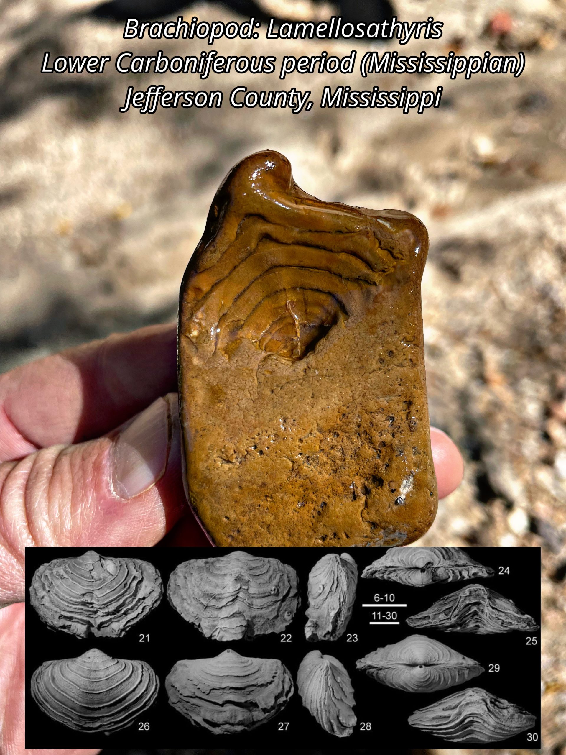
Brachipod Shells in Chert Gravel
Many in our state get introduced to rock and fossil collecting at a very young age by noticing the variety of patterns and colors among our local gravels. Many of the vibrantly colored stones are varieties of chert, quartz, carnelian, and agates. A number of the eye-catching structures found in our gravels are indeed fossils of ancient marine creatures! They are the preserved remains of invertebrate animals that lived hundreds of millions of years ago. These invertebrate fossils found in our chert gravels lived during a time called the Paleozoic era, long before the days of the dinosaurs. In fact, these gravel fossil finds are some of the oldest known fossils from our state!
Some of the common types of fossils found in our chert gravels are Brachiopod shells. Brachiopods were once a very diverse group of animals inhabiting the ancient warm, shallow seas during the Paleozoic era. They once dominated niches similar to those of modern sea clams. Though their shells may look similar, brachiopods are actually not that closely related to clams and other mollusks. Brachiopods still inhabit different environments within the world’s oceans today, but they are not nearly as diverse as they were hundreds of millions of years ago.
Today’s Fossil Friday brings us a chert gravel specimen of a brachiopod photographed in the field earlier this month by our MDEQ’s State Geological Survey scientists conducting routine fieldwork in the loess bluffs region of Jefferson County, Mississippi. This brachiopod fossil is called Lamellosathyris and is a particular type of extinct brachiopod belonging to a group called athyridides (thanks to our dear friend, Asa Asa, invertebrate paleontology expert from Missouri). It originated in limestone bedrock in the central Mississippi River Valley which date to the early Carboniferous period (Mississippian), some 350 million years ago.
This fossil was permanently preserved when silica-rich groundwater replaced portions of the ancient sea floor sediment, called limestone, which originally entombed the brachiopod. The brachiopod’s original shell dissolved away as the limestone sediment surrounding the animal was replaced with microcrystalline silica minerals, called chert. This ancient invertebrate fossil left a permanent, detailed impression of the fossil shell in the rock, preserving its appearance just as it was when it was buried hundreds of millions of years ago. This type of fossil cavity in the rock is called a fossil “mold”. After being locked in stone for hundreds of millions of years, the fossil mold was later exposed when the rock broke naturally, revealing once again the impression of the ancient sea floor and just a few of the animals that inhabited it.
Mississippi’s chert gravels were brought here naturally over millions of years by the ancient courses of rivers that eroded and drained ancient Paleozoic bedrock up in the mid-continent. These rivers carried with them an abundance of fossil-rich chert gravel in their bedload, leaving behind extensive deposits across Mississippi.
Our MDEQ State Survey geologists map the occurrences, quality, and distribution of Mississippi chert-rich gravel deposits. Gravel fossils help our scientists understand the shifting of bedrock sediment sources into the lower Mississippi Valley over time.
Chert gravel is an important economic resource for aggregate in our state. It is used in many important construction and infrastructure industries, including road building and cement manufacturing. Where gravels are naturally reworked from ancient terrace deposits into our state’s drainages, this coarse aggregate provides important stability to stream beds and provides essential habitats for native fish and aquatic invertebrates.

Pleistocene Deer Remains from Jefferson County, MS
White-tailed deer (Odocoileus virginiana) have played an important role in Mississippi’s ecology since ancient times. They are highly populous around nearly every corner of present-day Mississippi, and they likewise have an abundant presence in the state’s fossil record, dating back tens of thousands to and likely several million years. White-tailed deer ancestors go back to about 5 million years in North America, in a time called the Pliocene. Modern white-tailed deer evolved in North America from the similar ancestral species O. brachyodontus, some 3.5 million years ago.
For today’s fossil Friday, we are featuring multiple skeletal fragments of prehistoric deer from a period of geologic time called the Pleistocene epoch, which ranged from approximately 2.58 million to about 11,700 years ago. It was during this time that the Earth was going through several of its most geologically recent and severe glaciation cycles, or ice ages. In Mississippi’s geologic record, this period is represented by massive accumulations of a sediment called loess along the eastern valley wall of the Mississippi River. In this region (known as the Loess bluffs), thick deposits of windblown silt called loess, a very fine drained sediment, formed as a product of the continent-wide freeze-thaw cycles of these glacial periods. As large portions of ice sheets melted during warmer seasons, the glacial melt water would accumulate and transport massive amounts of sediment to lower elevations and eventually down the Mississippi River in its floodwaters. As this glacial melting came to a stop during the colder, drier seasons, large expanses of the once submerged floodplain of the river’s lower valley would dry up, exposing these fine, glacially ground up sediments to the strong winds coming across the coastal plain. Over time, these would pile up in thick layers along the valley wall of the Mississippi River and choke the tributaries that drain the bluffs region.
Preserved in these deposits, particularly along the smaller stream valleys dissecting the loess bluffs region, are fossils of diverse plant and animal remains, many which are now extinct, that once lived alongside ancient relatives of many of the organisms still alive in Mississippi today.
Earlier this week, our MDEQ state survey scientists, along with National Parks Service historian, Dr. David Slay (who has a personal interest in the fossils that can be found in the region) were investigating some of these loess outcrops and Pleistocene stream alluvium along a creek in Jefferson County, Mississippi, where he had previously noted numerous weathered bone fragments of Pleistocene megafauna on the sand and gravel bars. Among these fossils were many different skeletal fragments of ice-age megafauna including mastodon, antique bison, giant ground sloth, extinct horses, and even those of white-tailed deer. The white-tailed deer remains were abundant and ranged in age from modern to prehistoric, with many being fossilized and dating back to the height of the last glaciation event of the Pleistocene (some 20,000 years old).
Featured for today’s Fossil Friday are several skeletal elements of the fossil white-tailed deer found during the field survey earlier this week, including a partial antler, a lower jaw, a hoof, and a fragment of limb bone. One of the particularly interesting aspects of these various deer fossil skeletal remains is the information that they can provide into the complex process of fossilization. Although for certain remains it was difficult to ascertain a precise or age range, approximate age ranges could be hypothesized from how mineralized the bones have become, in this case phosphatized. In other words, how much of the original bone material had been replaced by phosphate minerals.
The fact that Mississippi has modern deer populations in addition to ancient populations represented by their rich fossil record offers a valuable scientific advantage for wildlife biologists and paleontologists alike when studying the evolutionary and ecological history of these animals. Extant deer species serve as modern analogues to fossils of their ancient ancestors and extinct relatives, offering valuable insights into how their physiologies, behaviors, and interactions with their environment have changed over deep time throughout Mississippi’s natural history.
 Ancient Billfish Discovery in Yazoo County

Some 38 million years ago during the later part of the Eocene epoch, central Mississippi was covered by a warm tropical sea. The evidence of this comes from the numerous perfectly preserved marine fossils found in what geologists call the Moodys Branch and Yazoo Formations. This interval of geologic strata is collectively called the Jackson Group, named originally from the geologic outcrops first described around our capital city, Jackson. Sharks’ teeth, giant oysters, and seashells from the late Eocene epoch have been found in outcrops of the Moody’s Branch and Yazoo Formations throughout the metro area.
Locked in time within the clays and marls of these two geologic formations are many fossils of ancient sea organisms that once lived here. The fossils of the Jackson Group include the remains of some of the largest animals alive on earth during this time period deep in our planet’s history, such as skeletons of giant ancient, toothed whales called basilosaurs and fossil teeth of some of the largest sharks to have ever lived. This makes the Moodys Branch and Yazoo Formations a treasure trove for our state scientists to study and learn from outcrops that provide rare windows into the distant past of our state’s natural history.
Scientific discoveries of all kinds are made through the important fieldwork of many of our state scientists and researchers. This week’s Fossil Friday highlights a fascinating discovery of fossil remains of an ancient billfish called Cylindracanthus rectus. The find was made by Conservation Resource Biologist Calvin Rezac at MDWFP’s Mississippi Museum of Natural Science while conducting joint research with our MDEQ Geological Survey scientists in the field earlier this week in Yazoo County.
Cylindracanthus was a primitive billfish whose genus dates all the way back to the Cretaceous period. It was a medium-sized billfish with a long and round rostrum (or bill) that came to a sharp point. In the oceans of the late Eocene, it swam alongside the much larger, more modern-looking billfish, Xiphiorhynchus, whose fossils can also be found in these same geologic formations. Cylindracanthus likely preyed on schools of fish the same way its cousin, Xiphiorhynchus and modern billfish do today, by slashing its bony pointed bill to spear and injure its prey before eating it.
In these late Eocene sediments, the long, thin rostrums of Cylindracanthus are typically only found as broken segments. Cylindracanthus fossils are much more commonly found in the shallower marine deposits of the Moodys Branch Formation than the deeper waters represented by the Yazoo Formation. They are also more commonly found than fossils of their giant Xiphiorhynchus billfish counterparts. Being a comparatively smaller fish, Cylindracanthus likely thrived by hunting in larger numbers and by inhabiting shallower marine environments.
Calvin’s Cylindracanthus fossil find has been accessioned into the state’s vertebrate paleontology collections for future studies on Cylindracanthus and other fossils of the Jackson Group. We at MDEQ appreciate working with our friends and fellow scientists at the MDWFP’s Mississippi Museum of Natural Science. Our collaboration helps us to better understand our environment, both in the deep geologic past and here in the present.
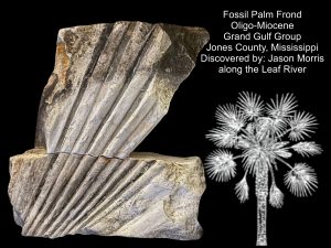 New fossil discovery in south Mississippi
For this week’s Fossil Friday, we are continuing the theme from our last adventure with another new fossil discovery in south Mississippi. The Catahoula, Hattiesburg, and Pascagoula Formations make up the Grand Gulf Group. Its geologic expression can be observed as a broad band of alternating sandstone, siltstone, claystone, and occasional orthoquartzite throughout south Mississippi and nearing our Gulf coast. It is the basis for the hilly terrain of the extent of the Southern Pine Hills region, immediately south of the Jackson Prairie region of central Mississippi. These deposits formed during the late Oligocene and through the Miocene epochs as global climates cooled and sea levels fell. River deltas built out vast new lands into the Gulf where seas once occupied. Fossils are particularly rare in the Grand Gulf Group of Mississippi, with the exception of some isolated areas where plant fossil remains have been discovered.
Our geologists know from studying modern river deltas that these deposits of the Grand Gulf Group of Mississippi formed in quite complex and dynamic systems. As river deltas build out into the Gulf, they create numerous sub-environments that include both fresh and brackish water systems. The energy levels of these systems vary, causing them to carry and deposit different types of sediment.
Early this month after attending Sunday church services, Jason Morris went out exploring along sandstone outcrops on the Leaf River in Jones County when he came across a large fan-shaped set of geometric impressions in the sandstone. Jason collected the large block of sandstone and carried it home. He then reached out to his friend, a quite knowledgeable fossil and artifact enthusiast, Angela Palmer Guy, for her advice about the find. Knowing its potential significance, Angela then reached out to our MDEQ State Geological Survey scientists on social media about Jason’s discovery.
Catahoula Formation of the Upper Oligocene epoch
Phosphatized Fish Scales from Blue Springs, Mississippi
 Last week, MDEQ State Survey Scientists along with Dr. Nina Riding from Delta State University led a group of undergraduate students on a field trip to Blue Springs, Mississippi. The focus of the trip was to observe and collect fossils along an outcropping of rocks belonging to the Coon Creek member of the Ripley Formation, deposited during the late Cretaceous approximately 70 million years ago. At that time, the region was still submerged by a shallow tropical sea, and many of the sediments that would eventually make up the rocks of this formation were transported by large coastal rivers into estuaries.
Prehistoric Shipworms from Wayne County, Mississippi
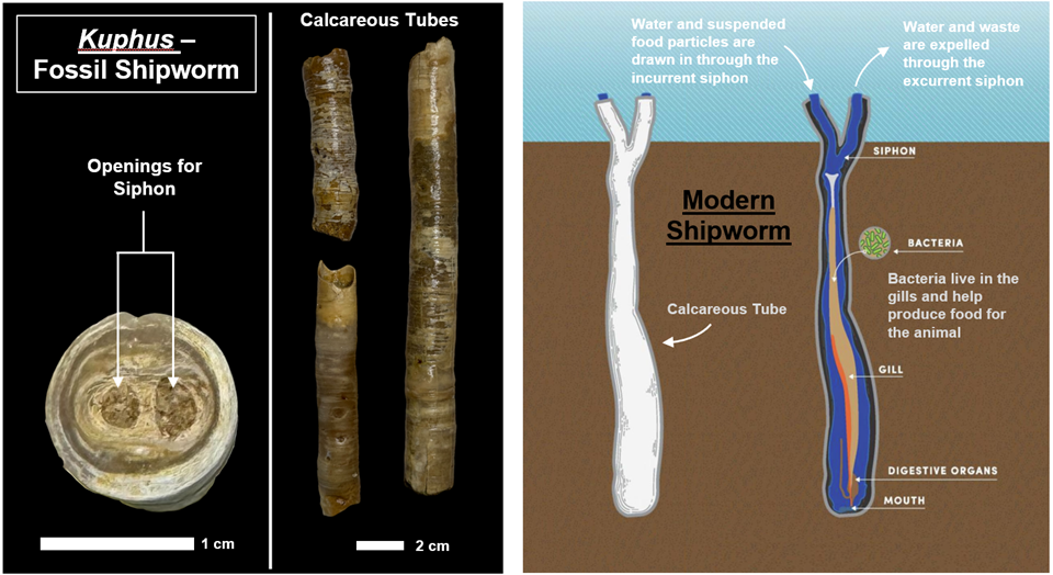
Today’s Fossil Friday features fossils of a boring bivalve called Kuphus, an ancient relative of modern shipworms. They were collected earlier this week by our MDEQ State Survey geoscientists while performing routine outcrop investigations along the Chickasawhay River in Wayne County, Mississippi.
In Mississippi, these fossils are preserved exclusively in rocks belonging to the Chickasawhay Limestone and Paynes Hammock Formations. These rocks formed between 23.8 and 28.5 million years ago at the end of a period of geologic time called the Oligocene Epoch. At this time, the region was submerged in a shallow tropical sea that was home to a great diversity of marine organisms. This was towards the end of the last major transgression (sea level rise) in the region, before waters gradually began to recede to reach present day sea levels. These organisms shared an environment with many other bivalve mollusks, along with other marine invertebrates including sea urchins and snails. In the waters above swam a host of different sharks and fish, along with extinct Sirenians, ancient relatives of modern sea cows, dugongs, and manatees.
Modern day shipworms got their name because of their elongated worm-like appearance as well as their habit of boring into the wood of sea vessels. In reality, these animals are not worms at all, but rather a unique type of bivalve mollusk, the same group of organisms that includes clams, oysters and mussels. These boring bivalves make their homes by creating burrows in hard substrates. While most of their bodies would remain burrowed in substrate, these bivalves had a specialized structure called a siphon that made contact with the sediment-water interface. The siphon has two passageways: the incurrent siphon, which draws in water and suspended food particles which then get filtered through the gills, and the excurrent siphon, which expels water and waste.
The structures that are preserved in our rock record aren’t fossils of the animals themselves but rather the calcareous tubes their bodies secreted while burrowed in the sea floor sediment. These structures lined the inner surfaces of the burrows they once inhabited, helping to protect them from predators and other environmental hazards. This form of fossil preservation is frequently observed in many calcium carbonate (calcite)-producing organisms, which include most bivalve mollusks as well as certain gastropods (snails) and foraminifera. While the internal soft parts of their bodies decay, their calcite shells can remain intact, preserved for tens of millions of years.
Rare Ocala Chert Artifact Discovered in Mississippi
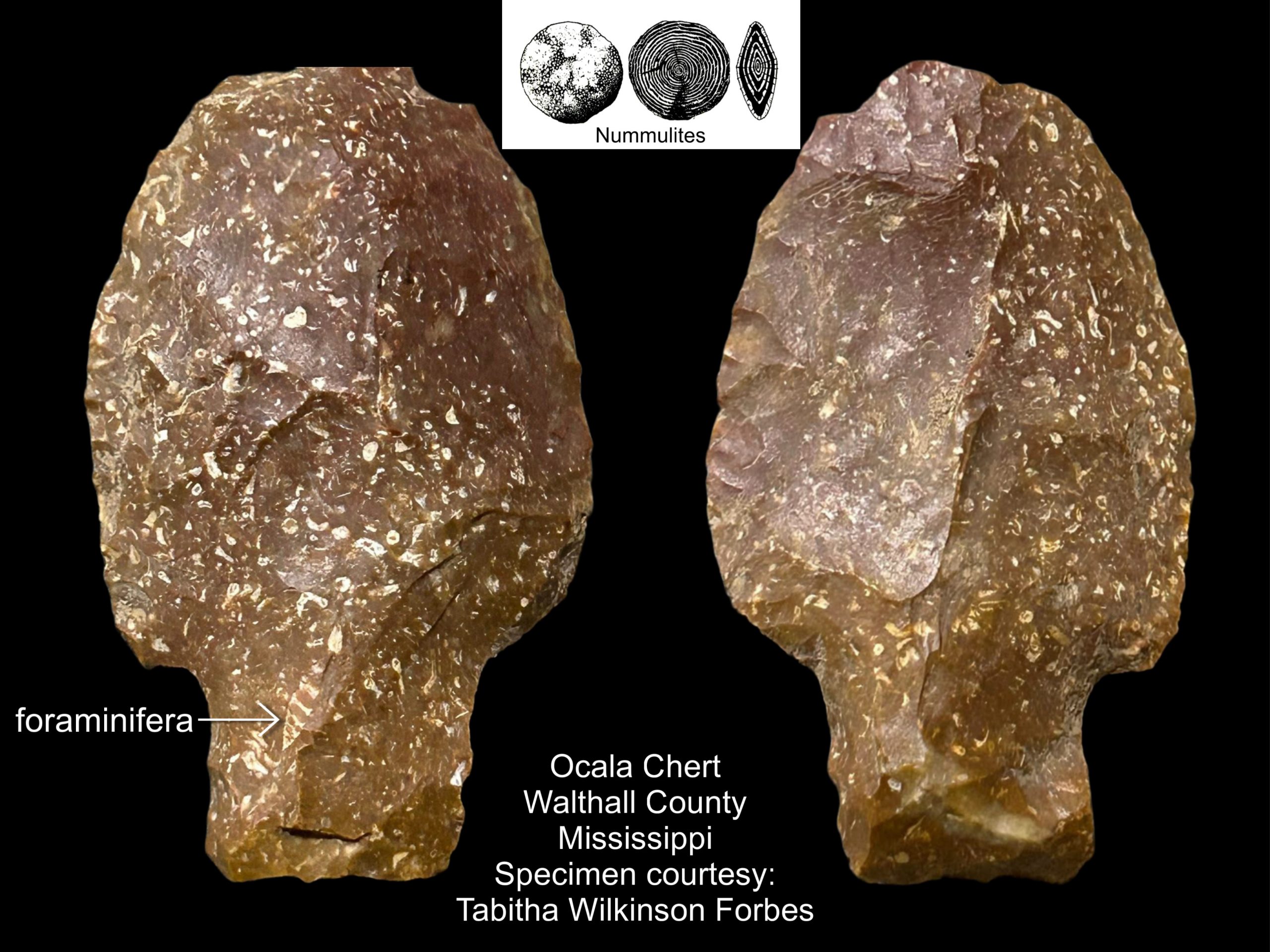 In archaeology, lithics are stone artifacts that have been purposefully modified, or worked, by human hands. In this science, where anthropological theory of the cultural past is pondered and debated largely on the examination of worked stone objects, an understanding of the presence and source of naturally occurring stones or native materials throughout the region is vital when investigating prehistoric indigenous archaeological sites. Natural availability and quality of geologic resources are not equally distributed. Therefore, understanding the source of these native lithic materials provides archaeologists insight into the relationships of past cultures with each other, their available geological resources, and how these relationships may have evolved.
Our chert gravels, naturally occurring in Mississippi, are all derived from limestone bedrock found throughout the mid-continent. We know this because of the abundance of Paleozoic marine fossils they contain, including crinoids, brachiopods, bryozoans, rugose and tabulate corals, and rare trilobites. Our MDEQ Mississippi Geological Survey Scientists can attribute many of the chert artifacts found on archaeological sites in Mississippi to a geologic source based on their fossil content and other diagnostic factors.
The Ocala Limestone is typically fossiliferous. It contains a wide variety of sea shell fossils along with an abundance of fossil foraminifera. Foraminifera are single-celled organisms whose abundant fossils are important resources geologists use for dating and correlating regional marine rock units. The Ocala limestone contains disk-shaped benthic foraminifera called Nummulites, whose skeletons make up a large portion of the rock. In the chert-replaced regions of Ocala limestone, much of the marine fossil content was erased by chemical dissolution, with the exception of these Nummulites fossils that are often still found preserved.
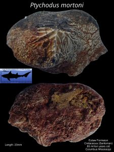 Ptycodus Discovery in Mississippi Fossil Park
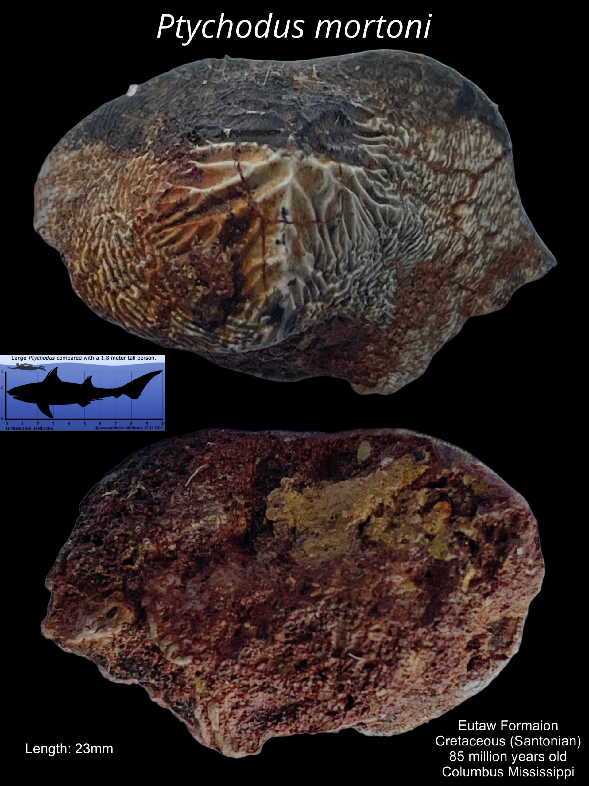
Earlier this week an MDEQ State Survey scientist and Mississippi Museum of Natural Science paleontologist led a field trip for nine Mississippi State University [geoscience] students from Dr. Renee Clary’s paleontology class. The trip was hosted by City of Columbus grant writer Susan Wilder. The focus of the trip was the outcropping of Cretaceous-aged fossil beds along Luxipillila Creek, the future site of the Dr. John “Jack” Kaye public fossil park in Columbus, the project which Susan Wilder spearheads.
 A New Columbian Mammoth Discovery near Lake in the Jackson Prairie Region of Central Mississippi
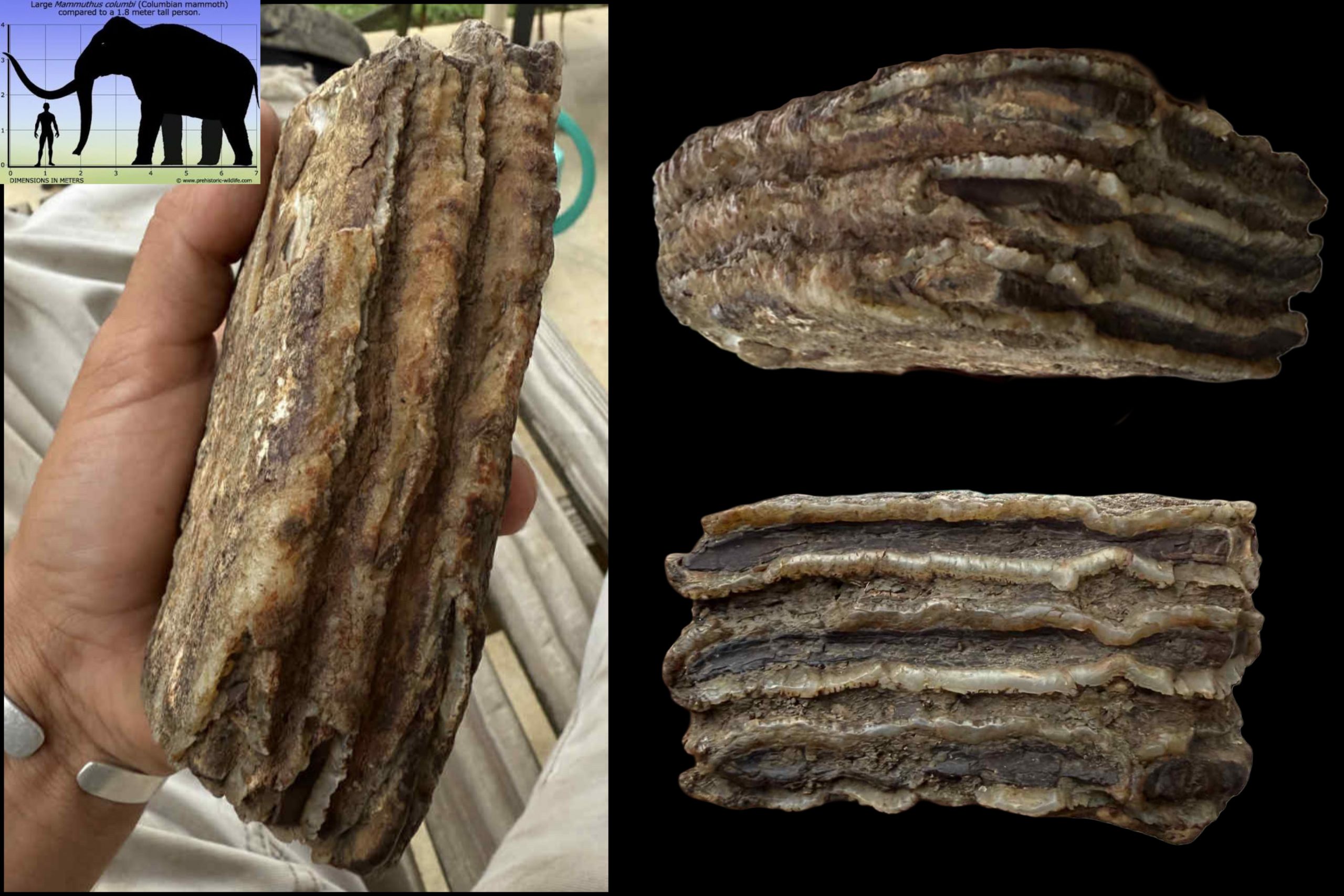
During his free time while working on his uncle’s farm near Lake in Newton County, 18-year-old Waylen Miller does what he enjoys most, looking for fossils. Waylen has found numerous marine fossils on the family farm dating back to the late Eocene when a worldwide rise in sea levels caused much of our state to be covered in a deep ocean some 38 million years ago. One particular fossil Waylen discovered on the farm was a nearly complete nautiloid called Aturia, a type of extinct cephalopod, which he carefully reconstructed. It was featured in one of our previous Fossil Friday posts.
The physiographic region through central Mississippi known as the Jacks Prairie is underlain by the deposits of an ancient seabed called the Yazoo Formation. The rich soils of the Jackson Prairie took tens of thousands of years to form atop the Yazoo Formation bedrock of the region. These ancient prairie soils were important to the development of Mississippi’s earliest agricultural industry and are just as significant to it today.
This time, Waylen’s fossil find was not of an ancient sea creature from the Eocene, but something more directly tied to the evolution of our Jackson Prairie region itself, a giant portion of a Columbian mammoth tooth from the Pleistocene epoch. Last year the evidence of Columbian mammoths occupying the Jackson Prairie was first reported on with the excavation of a complete tusk, excavated by our State Survey scientists in the loess bluff’s region of western Madison County. Waylen’s find is much farther east than the Jackson Prairie of the loess bluffs region. This has important implications on the broader landscape and ecology of the Jackson Prairie, not just during the ice ages of the Pleistocene epoch, but also how we understand it today.
Columbian mammoths were much larger than the infamous woolly mammoths that roamed the colder, more northern regions of North America. They were true giants! Columbian mammoths grew up to 15 feet at the shoulder and could weigh over 10 tons. They were also likely less hairy – appearing more like modern elephants. Living in warmer, more southern climates, they didn’t need the thick coat like their wooly relatives to the north.
Waylen’s discovery offers a rare window into the distribution of Columbian mammoths that once roamed central Mississippi along the Jackson Prairie. Because of Waylen’s find we now know they were much more widespread across the Jackson Prairie and not isolated to just the loess bluffs region of the prairie in the western part of our state.
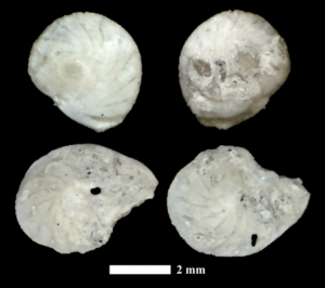 Benthic Foraminifera from the Demopolis Formation in Clay County, Mississippi
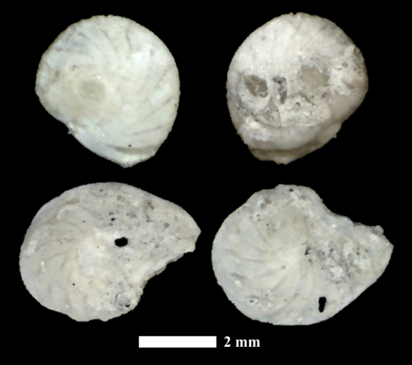
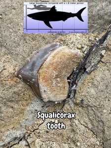 Mississippi’s Ancient Shark — The Squalicorax

Mississippi has a rich geologic past with a fossil record that includes a history in the Mesozoic era, also better known as the days of the dinosaurs. Outcrops from the Late Cretaceous period underly the rich soils of the Black Prairie and uplands of the Pontotoc Ridge physiographic regions of northeast Mississippi. Much of these deposits were formed in warm tropical shallow seas teaming with life and now rich with their fossil remains.
While the dinosaurs walked and ruled the land, giant marine reptiles and a variety of ferocious sharks ruled these ancient seas. Fossil bones and teeth of these animals are commonly found along an abundance of ancient seashells from mollusks in most outcrops of Cretaceous age in Mississippi.
The currents, waves, and storms along with scavengers tend to widely scatter marine vertebrate remains. Therefore, actual fossil skeletons of these animals are important and rare finds. More commonly found are isolated bones and teeth. Particularly sharks’ teeth are abundant in these marine deposits found in northeast Mississippi. Sharks are cartilaginous fish, which means their bones are made of rigid tissue called cartilage and not solid mineralized bone like other vertebrate animals. Therefore, their skeletal remains do not tend to preserve well in the fossil record. Shark’s teeth (which are actually modified scales) preserve excellently in Mississippi’s fossil record. The relative abundance of shark teeth that can be found in Mississippi, particularly in our Cretaceous deposits, isn’t necessarily because there was an abundance of sharks (which there indeed were). The abundance has to do with the fact that sharks lose and replace hundreds or even thousands, of teeth over the course of their lifetime. This is really what makes their fossils abundant in our state’s marine deposits.
Today’s Fossil Friday brings us a tooth of an extinct Late Cretaceous shark called Squalicorax. It was photographed in the field from a marine sand bed in the Prairie Bluff Formation while conducting fieldwork in April with Mississippi Museum of Natural Science in Starkville Mississippi and accessioned into the museum’s paleontological collections.
Squalicorax was a large lamniform shark commonly called the “crow shark” and had global distribution during the Late Cretaceous. They were an apex predator growing up to 10 feet in length and may have weighed upwards of 1,000 pounds. Squalicorax had razor sharp serrated teeth and fed on fish, marine turtles, and even mosasaurs. They were also scavengers as their teeth and bite marks have been found on dinosaur remains from carcasses that likely floated out to sea. We do know quite a bit about Squalicorax thanks to an extremely rare, nearly complete skeleton that was recovered in Kansas and is now on display at the Smithsonian Institution.
Squalicorax went extinct following a giant catastrophic meteorite impact near the Yucatán Peninsula in the Gulf of Mexico at the end of the Cretaceous period. This extinction event killed off 75 percent of all life on earth including all of the non-avian dinosaurs. Our MDEQ State Geological Survey scientists find evidence of this catastrophic event in the Starkville area by studying and mapping the geologic contact of the Late Cretaceous period Prairie Bluff Chalk Formation with the overlying Paleocene epoch Clayton Limestone Formation. This makes our featured shark specimen one of the last Squalicorax to live on earth.
Northeast Mississippi is a wonderful place to for scientists to study this globally important geologic boundary that ended the days of dinosaurs and Squalicorax because it outcrops from Tippah County, Mississippi along the Tennessee state line, south through Kemper County, Mississippi to the Alabama state line.
Opal and the discovery of an ancient prehistoric industry 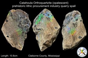

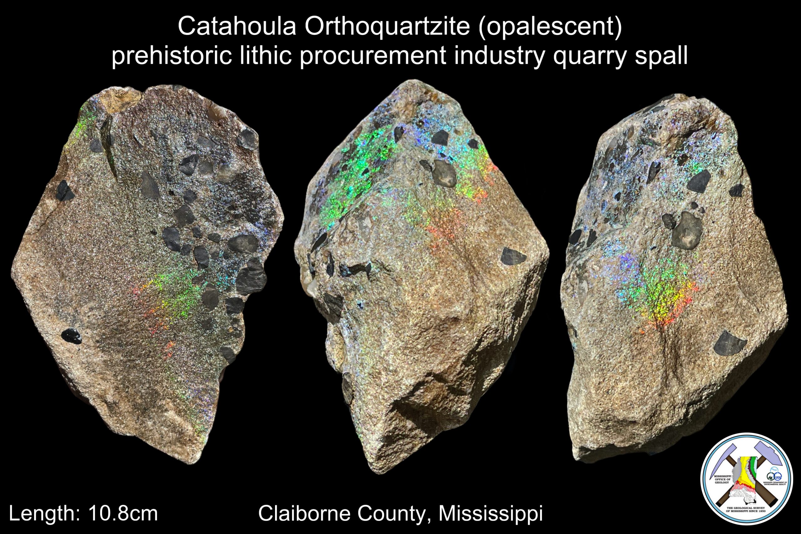
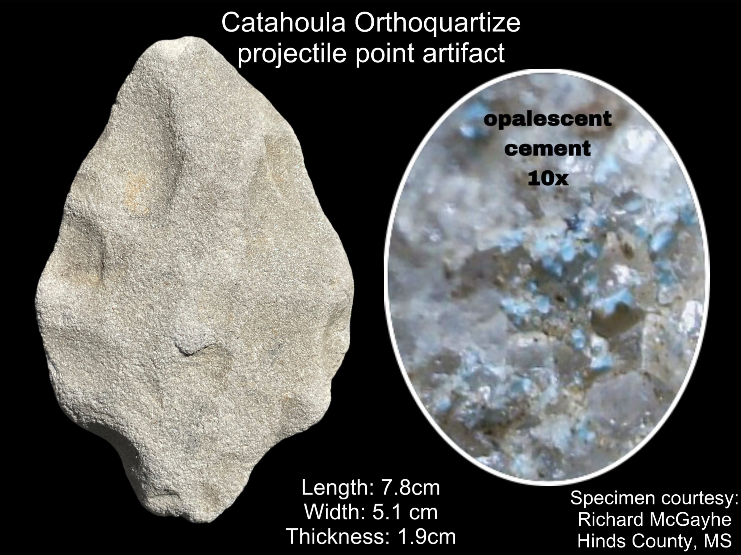
In archaeology, lithics are stone artifacts that have been purposefully modified, or worked, by human hands. In this science, anthropological theory of the cultural past is developed largely based on the examination of worked stone objects, so an understanding of the presence and source of naturally occurring stones or native materials in relation to the local geology is vital when investigating indigenous archaeological sites. Natural availability and quality of geologic resources are not equally distributed. Therefore, understanding the source of these native lithic materials provides archaeologists insight into the relationships of past cultures with each other, their available geological resources, and how these relationships may have evolved over time.
At the surface, Mississippi’s geology resides entirely in the Gulf Coastal Plain. This means that all the deposits found at the surface are sedimentary in origin. Mississippi is comprised of alternating layers of various sands, silts, limestones, and clays that may only locally form into hard rock. Gravel deposits were brought by rivers that crossed the coastal plain, carrying chert along with a host of other rock types from distant bedrock regions.
Mississippi’s prehistoric cultures predominantly utilized varieties of chert and orthoquartzite for producing knapped stone tools. This was due to their inherent mechanical property which causes them to produce a predictable conchoidal fracture as well as their local availability as a geologic resource. Other geological resources were also modified and utilized in various ways according to their own suitability and physical properties.
When our MDEQ’s State Geological Survey scientists are working in the field to map and interpret our state’s geology, they often encounter evidence that they were not the first people to visit geologic outcrops. This is particularly true in regions containing exposures of lithic-quality rock resources.
Our State Geological Survey scientists have documented a number of prehistoric quarrying sites throughout the state during their routine field research. Some lithic quarries are so extensive that they could be considered industry-level in size, with disturbances measuring acres in area, and were likely in operation for thousands of years. Direct evidence also suggests that some of these rock resource procurement sites were in use by some of the first peoples in Mississippi, going back to the last ice age. Some of these prehistoric quarry sites our survey scientists have discovered contain lithic types that are completely new to the science of archaeology and change the science’s understanding of cultural exchange and trade networks.
Earlier this month, our State Survey geologists made another such discovery in Claiborne County while investigating outcrops of mid-Pleistocene Pre-loess Terrace Deposits and the underlying late Oligocene Catahoula Formation. Both of these geologic units are known by our scientists to contain high-quality lithic resources once important to the state’s prehistoric indigenous inhabitants. The Pre-loess Terraces contain gravel chert and a wide variety of other rock types that our survey scientists have documented to have been heavily exploited throughout our state’s rich cultural prehistory. The Catahoula Formation contains both sandstone and high-quality knappable orthoquartzite but very little is known yet about its exploitation, use, and distribution by Mississippi’s prehistoric cultures.
Gem-quality precious opal was discovered by our MDEQ State Geological Survey scientists in the sandstones of the Catahoula Formation of south Mississippi, and Mississippi Opal was designated by our legislature as the state’s official gemstone in 2023. The Catahoula Formation also has been documented by our survey scientists to contain orthoquartzite cemented by common opal that was utilized by Mississippi’s prehistoric indigenous cultures. But did the early Native American inhabitants ever discover and develop the precious opal as a resource?
Until very recently our scientists could only suggest that they likely did, given their superior knowledge of the land. This was only speculation given that no artifacts of Mississippi Opal had ever been documented by our scientists at either a prehistoric quarry in the Catahoula Formation or recognized while working with archaeologists on lithic assemblages found on prehistoric archaeological sites. This story changed dramatically with two recent discoveries made by our MDEQ State Survey geologists both in the field and in the lab.
Earlier this month a vibrantly-colored, opalescent Catahoula Orthoquartzite quarry spall artifact of Mississippi Opal was found by our scientists researching outcrops in southwest Mississippi. It was found among numerous other non-opalescent Catahoula Orthoquartzite quarry spalls resulting from prehistoric mining activity. Was this just a happenstance occurrence that some gem-quality opalescent material was encountered during lithic procurement at this prehistoric quarry site, or was it also valued and intentionally utilized in stone tool manufacturing?
This posed difficult questions for our survey scientists to answer for a couple of reasons. First of all, there are not very many Catahoula Orthoquartzite artifacts that our survey scientists have identified working with archaeologists on artifact assemblages. This is because it was only within the last few years that our scientists had recognized and reported through geologic mapping that high-quality orthoquartzite was even available from the Catahoula Formation in Mississippi and demonstrated to the archaeological community that Catahoula Orthoquartzite was utilized in the prehistoric archaeological record. Secondly, the opal-silica cement of the Catahoula Orthoquartzite is chemically variable and tends to be unstable, often degrading back to a sandstone. This makes for poor preservation of it in the archaeological record.
After the discovery of the Mississippi Opal prehistoric quarry spall earlier this month, our MDEQ State Geological Survey scientists began to look closer in the laboratory at the known Catahoula Orthoquartzite arrowheads and other prehistoric artifacts for any signs that any of them might have been made from the newly-discovered opalescent material. The answer came last week with a resounding yes!!! Our survey scientists were elated to find evidence of residual opalescent cement still preserved between sand grains of a prehistoric Catahoula Orthoquartzite artifact while examining a fragile, water-worn, and deeply chemically weathered projectile point in detail under a high-powered microscope. This unassuming Catahoula Orthoquartzite artifact was found last year near Clinton, Mississippi in Hinds County by Richard McGayhe, an avid arrowhead hunter and son of former State Archaeologist Sam McGahey.
The work of our MDEQ State Geological Survey scientists demonstrates that this ancient projectile point was indeed made from the same amazingly beautiful, vibrantly colored Mississippi Opal orthoquartzite stone that our scientists found in the field earlier this month. The discovery that gem-quality Mississippi Opal orthoquartzite was once mined, utilized, and likely highly prized by our ancient Native American inhabitants is now a unique story to add to our state’s rich prehistoric archaeological record.
Though the artifact is not made in a style that is age-diagnostic for a particular prehistoric cultural time period, future archaeological finds will undoubtedly shed more light on the timing and use of Mississippi Opal by our state’s indigenous cultures. An indigenous prehistoric procurement industry of gem-quality opal for the use in knapped lithic tool manufacturing has likely never been documented anywhere else in North America.
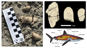 Coprolite Discovery Sheds Light on Ancient Marine Life
This week’s fossil Friday features a set of three associated coprolites recently collected by MDEQ’s State Geological Survey scientists performing routine outcrop investigations in Yazoo County. Coprolites are fossilized animal dung and are unique types of trace fossils, or ichnofossils. Ichnofossils are not the fossils of the animal themselves, but rather things that the animal left behind in life. They can be things like footprints, feeding traces, burrows, or coprolites. Each type of ichnofossil provides information on different aspects of animal behavior but coprolites particularly can offer some of the most interesting details about an animal’s life.
Much like how modern animals can be identified from their feces, or scat, scientists can assess coprolite morphology to help determine their species of origin. The coprolites featured in today’s Fossil Friday belonged to an Elasmobranch. Elasmobranchs (Elasmobranchii) are a subclass of cartilaginous fish that include modern sharks, rays, skates, and sawfish. The preserved half-cylinder structures of these coprolites are portions of what were once a more complex coiled shape. This morphology is a diagnostic characteristic resulting from a digestive structure called a spiral valve, a unique feature in the lower part of the intestine of some sharks.
These fossils were collected from a bedding plane exposed in a clay clast of lower Yazoo Formation, making them around 38 million years old. The animal that produced these fossils lived during a time called the Late Eocene when this region was covered deep undersea. The organism responsible for these fossils would have shared these waters with massive ancient toothed whales called basilosaurids (Mississippi’s official State Fossil) along with some of the largest sharks that ever lived.
In addition to coprolites, Elasmobranchs and other fish are known from their fossil teeth and predation and scavenging traces they left on bones of other fossil vertebrates. These are all incredibly important tools our scientists use when reconstructing the ecosystems of these ancient environments.
Coprolites such as these can also sometimes preserve elements of smaller fossil organisms these animals would have preyed upon. Studying these fossil coprolite contents can provide further insight into the diet and health of extinct animals beyond what may only be suggested or implied from just the fossils of their bones and teeth.
Mississippi’s Wealth of Ancient Marine Fossils in Chert Gravel
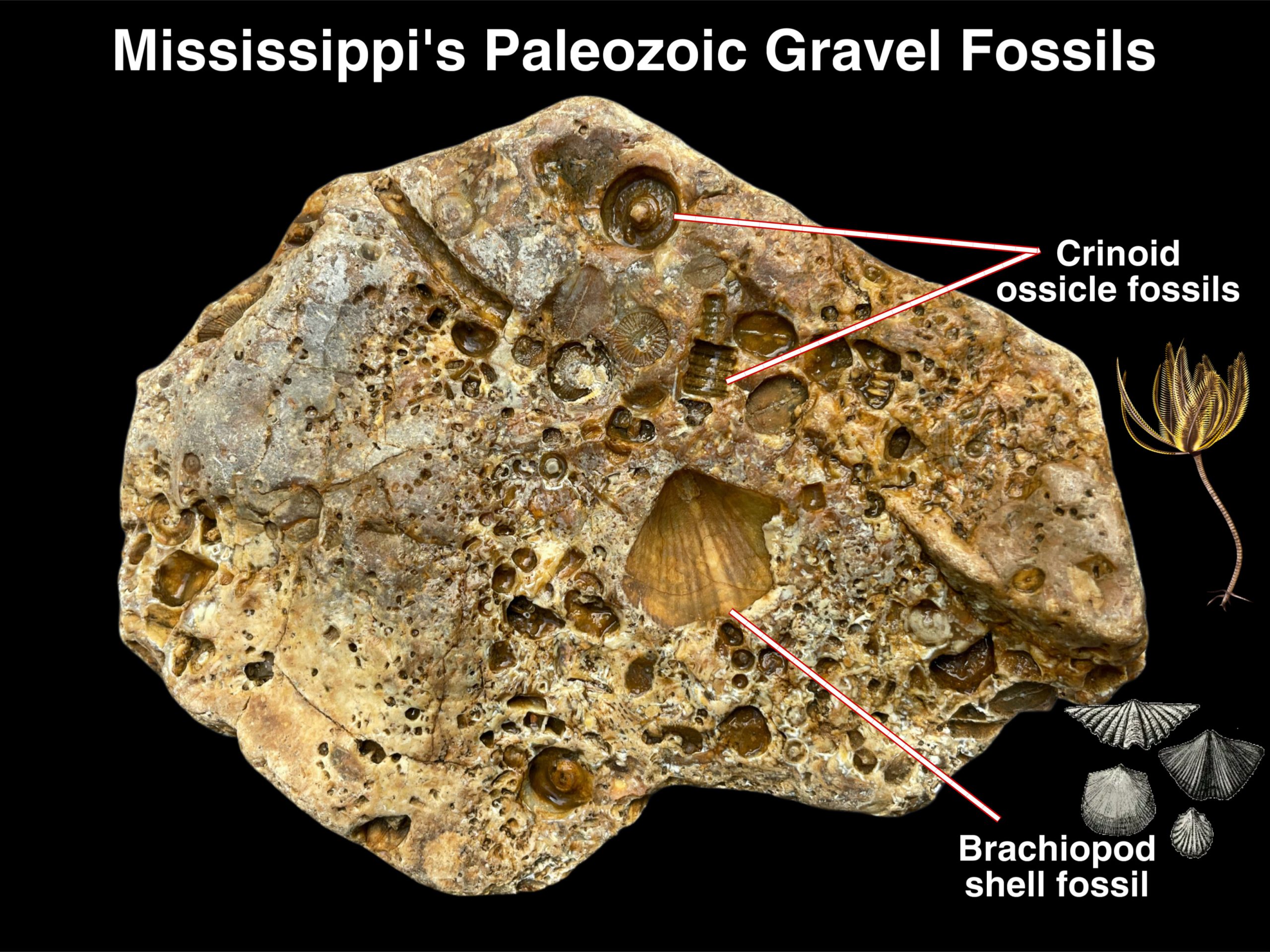
One of the most common chert gravel fossil finds are the remains of animals called crinoids. Crinoids are sometimes referred to as “sea lilies” but they are not at all plants. They are actually animals called echinoderms, closely related to modern starfish and sea urchins. Crinoids still exist but only inhabit rare environments in the oceans today. They were once much more common in the oceans hundreds of millions of years ago.
More on rocks and fossils from our Mississippi gravel: Rocks And Fossils Found In Mississippi’s Gravel Deposits – MDEQ
Newly discovered portion of a lower jaw of an American mastodon found.
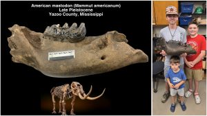 Today’s Fossil Friday brings us the amazingly well-preserved find of a newly discovered portion of a lower jaw of an American mastodon found earlier this month by amateur fossil hunters, J.P. Ketchum and Tylnn Sanders from the loess bluffs region of Yazoo County, Mississippi.
Mississippi was home to three Proboscideans during the last ice age which began around 110,000 years ago and ended roughly 11,700 years ago. These colossal giants include the American mastodon, gomphothere (Cuvieronius), and the Columbian mammoth. All three were true giants and possessed ivory tusks. Mastodons are by far the most common Proboscidean finds in Mississippi as they were browsers, like modern deer, and could inhabit a variety of different environments. Mammoths which were related to modern elephants are far less common finds in Mississippi as they are strictly grazers. They were isolated to open grassland would have been at home in only a select few ecological regions of the state, particularly the prairies of Mississippi. Gomphotheres from the Pleistocene epoch are really only known from a couple of isolated teeth found along the Mississippi River.
The mammoth was the closest relative of modern elephants and a late arrival on the North American continent, sometime during early Pleistocene (some 1.5 million years ago). Mammoths migrated from Eurasia, while the mastodon has far deeper roots in North American geologic history going back to the late Miocene (approximately 8 million years ago). Little is known about our third ancient elephant relative from Mississippi’s fossil record, the stranger-looking closer relative of the mastodon, the Gomphotheres, but fossils are known from south Mississippi dating as far back to the late Miocene age Pascagoula Formation.
Far away from the continental glaciers to the north, Mastodon would have been a common site throughout Mississippi’s ice-age landscape along with a host of now extinct animals such as mammoths, giant ground sloths, giant beavers, tapirs, horses, musk ox, stag moose, and giant bison. But also ferocious predators like great short-faced bears, American lions, dire wolves, and saber-toothed cats. Also living among them were more familiar animals that still roam our lands today, such as deer, turkeys, alligators, and black bears.
The first Native Americans also migrated into North America sometime during the height of the last glacial maximum (somewhere between 20,000 to 15,000 years ago). They entered a land the untouched ice-age world with a bounty of enormous megafauna and a wealth of diverse natural habitats to exploit. They likely migrated into Mississippi following the great herds of mastodon.
At the end of the Pleistocene epoch, the mastodon and its other elephant relatives, along with the rest of the iconic ice-age megafauna became extinct as the climate began to warm to become more like it is today.
J.P. Ketchum and Tylnn Sanders’ amazing find of the mastodon jaw was donated earlier this month to the Mississippi Museum of Natural Science. MDEQ’s State Geological Survey scientists in the Office of Geology have been working to study the newly-discovered fossil specimen and the museum’s paleontologist since the donation of the specimen. Our state Survey scientists will be leading a team in the field this week to study the geologic setting of the site where mastodon fossil was found and also try to locate more of the skeleton that might still be preserved.
High school students made extraordinary discoveries in Tippah County: fossils from the age of dinosaurs that still gleam with their original mother-of-pearl shell.
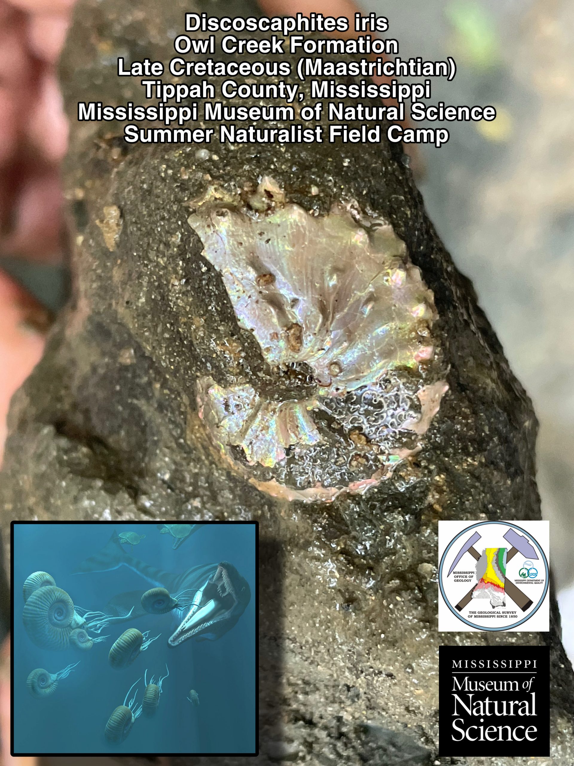 Last week, high school students from all over the state attending the Mississippi Museum of Natural Science’s Summer Naturalist Field Camp got experience working side by side with professional scientists in various disciplines on a broad number of projects. Their experience included an entire day in the field collecting with state survey geologists from MDEQ’s Office of Geology in an adventure lead by the museum’s paleontologist to an important late Cretaceous fossil site in northeast Mississippi.
 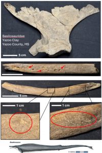 Newly Discovered Fossil Whale Remains in Yazoo County, Mississippi
Today’s Fossil Friday features fossilized bones from an ancient whale recently discovered by our MDEQ State Geological Survey scientists preforming routine outcrop investigations research in Yazoo County. Buried beneath thick ice-age Pleistocene loess silt and Pre-loess Terrace sand and gravel cover under much of Yazoo County is a thick layers of clay that records a period of time between 37.2 and 33.9 million years ago called the late Eocene, when this region was deep undersea. Here, ancient ancestors of all present-day whales were toothed whales known as Archaeocetes that called these deep waters home.
The recent findings, which included a partial scapula (shoulder bone) and two ribs, belonged to a member of a diverse family of Archaeocetes called Basilosauridae. This newly discovered specimen provides an exciting glimpse into both what occurred during the animal’s life and what had transpired after its death.
These massive marine mammals, which grew up to 60 to 70 feet in length, shared a habitat with a diverse array of other carnivorous open-water organisms. Some of which were deft predators such as Otodus auriculatus (one of the largest sharks to ever live) and also its cousins, the smaller fossil whales such as Zyghoriza, Durodon and Cynthiacetus along with a host of others opportunistic scavengers who fed on the remains of animals, both big and small. Examples of such predatory and scavenging behaviors are exceptionally well- preserved along the surfaces of this newly-discovered archaeocete fossil bones. This is evident as exceptionally well preserved bite and scratch marks from the teeth of sharks and other fish that once feasted on the bounty of this massive animal shortly after it died.
The fossil whale is the official State Fossil of Mississippi and this particular part of Mississippi is well known to yield many basilosaurid fossil remains. One of the things that stood out about this particular specimen is that the bones were not quite nearly as robust as most of the others recovered from the region. A closer laboratory examination of the remains revealed that the bone walls were distinctly thin, an unusual condition for these animals that used their thickened bone mass as ballast as an adaptation for a fully aquatic lifestyle.
Another intriguing aspect of this ancient vertebrate fossil find was the presence of pit-like structures along much of the surface of the bones. This is evidence that this animal likely sustained some sort of pre-mortem injuries, known as pathologies. These may have likely been due to a skeletal disease that affected the animal while it was still alive, possibly even inhibiting its normal growth or maybe even contributing to its ultimate demise, but this remains speculative since the nature of this potential illness is not yet known.
Further research on this unique vertebrate specimen will hopefully shine light on some of these questions, but there is no doubt that this discovery marks an important addition to Mississippi’s rich fossil record, offering additional insights into the lives and characteristics of some of the largest animals to have ever dwelled in Earth’s oceans.
A Dire Wolf Fossil from the Late Pleistocene of Northeastern Mississippi
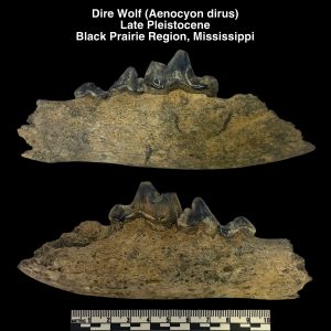 The first Native Americans migrated into North America sometime during the height of the last glacial maximum (somewhere between 20,000 to 15,000 years ago). They entered an untouched ice-age world with a bounty of enormous megafauna and a wealth of diverse natural habitats to exploit.
In Mississippi (far away from the continental glaciers to the north) our prairies, uplands, and bottomlands hosted now extinct animals such as mammoths, mastodons, giant ground sloths, giant beavers, tapirs, horses, musk ox, stag moose, and giant bison. Also living among them were more familiar animals that still roam our lands today, such as deer, turkeys, alligators, and black bears.
During the late Pleistocene epoch, the first humans were not the only apex predators to call Mississippi home. Fossil remains of great short-faced bears, American lions, and saber-toothed cats have all been found in Mississippi dating back to this time period.
Another great ice-age predator, the legendary dire wolf (Aenocyon dirus), is also known from fossils found in Mississippi. The dire wolf grew to about the size of the largest modern grey wolves (about 160lbs), but its jaws were much stronger and its teeth much larger, making them exceptionally well-adapted to hunting the large ice-age mammals that shared its environment.
Today’s Fossil Friday brings us an exceptionally well-preserved dire wolf jaw from the Black Prairie region of northeast Mississippi. It was photographed by our MDEQ’s State Geological Survey scientists last month during a public outreach and fossil identification session in Columbus, MS and donated to the paleontological collections at the Mississippi Museum of Natural Science by Jacob Tucker.
The dire wolf inhabited our area likely from the late Pleistocene into the early Holocene, approximately 125,000 to 10,000 years ago. There is no doubt these creatures lived alongside the first humans in North America’s ice-age environment but there is still little we know about their physical appearances and how they behaved. We can surmise that the fur coats of dire wolves living in Mississippi may not have been entirely white, which was an adaptation more suited to blend in with the snowy environments further north. Their social behaviors, such as whether they were solitary or lived and hunted packs, remain a mystery.
What we can learn from fossils like Jacob’s donation is information about the environments they once inhabited. Because of fossils like Jacob’s, which are very well preserved, chemical signatures in the teeth can host a treasure trove of information about the animal, its life history, its environment, and even specific details about its diet.
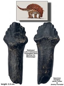 Nodosaur, A Fossil Dinosaur Find From Northeast Mississippi
Our MDEQ State Geological Survey scientists are often asked, have dinosaurs’ fossils ever been found in Mississippi? The answer is a resounding, yes! Dinosaur fossils have indeed been found here, but little is known about dinosaurs found here compared to the enormous amount of information we have about them from the western parts of the United States.
This very limited information on dinosaur fossils we have here in the east, compared to that of the west, is for a number of reasons. First, much of the deposits from our dinosaur-age geology exposed at the surface in eastern North America is mostly from the Cretaceous period, the last period of Mesozoic era. Secondly, during this time there was a shallow seaway that separated the eastern and western halves of the North American continent. Thirdly, much of the geology exposed at the surface here, particularly in Mississippi that dated from the late Cretaceous are marine deposits. Therefore, most of the dinosaur fossil finds we have recorded here are just from fragmentary remains of carcasses that were swept out to sea and were heavily scavenged and dismantled by sharks and other fish. The more complete fossil record out in western United Stares is far better studied, and very little scientific attention has been given to studying the dinosaur fossils found here in the southeast.
Here in Mississippi, outcrops of our Cretaceous-age geology are restricted to just the northeastern part of the state. These formations encompass richly fossiliferous strata, containing an abundance of the well-preserved remains of invertebrates along with vertebrate remains fish and even extinct marine lizards such as mosasaurs and plesiosaurs. The remains of giant flying reptiles called pterosaurs have also been found in these ancient beds of sediment here in Mississippi.
So, what kinds of dinosaurs have been found in Mississippi? Most of what we know about our dinosaur’s diversity here is only known from isolated bones and teeth. The most commonly found remains are from the plant-eating duck-billed dinosaurs called hadrasaurs, also called the “cattle of the Cretaceous”. Small meat-eating raptor dinosaurs, called dromeosaurs (similar to Velociraptor) have also been found. Even a tooth of a horned dinosaur, a ceratopsian, was recently discovered in Mississippi. Very odd-looking dinosaurs called ornithomimosaurs once also called Mississippi home. These giant bird-mimicking dinosaurs were very ostrich-like in appearance and were almost certainly completely feathered dinosaurs. More famously, some remains of large theropods (relatives of T. rex) have been found in Mississippi.
How are dinosaurs found and reported in Mississippi? Most of what we know about the record of dinosaurs in Mississippi comes from the public, interested fossil collectors that bring their finds to our state’s scientists’ attention for identification. Today’s Fossil Friday brings us to the Mississippi University for Women’s Plymouth Bluff Environmental Center near Columbus, Mississippi. Last month MDEQ’s State Geological Survey scientists helped the Mississippi Museum of Natural Science with an evening fossil program open to the public at the interpretive center at the park. Following a lecture on the Cretaceous paleontology and science history of Plymouth Bluff given by museum’s paleontologist and curator George Phillips, the public was invited to bring their fossil collections in to display and have their finds identified by a state scientist.
After the lecture, one of our State Survey scientists were working with a collection of fossil teeth brought in by a northeast Mississippi fossil collector, Jacob Tucker. Most of the fossil material in Jacob’s collection were from the Pleistocene epoch (which are also common fossil finds in prairie regions of northeast Mississippi). One tooth in particular in the collection caught the attention of our MDEQ State Geological Survey scientist. The tooth was found along an outcrop of the Late Cretaceous in age, Tombigbee Sand Formation in Monroe County, Mississippi by Jacob and his friend Jeremy Forrester on June 16th of 2021. It was not the tooth of an ice-age mammal, it was the tooth of a Dinosaur!
The small leaf-shaped tooth Jacob and Jeremy found was diagnostic of very unusual kind of dinosaur. It was identified by one of our MDEQ’s State Survey scientists as belonging to a heavily-armored plant eating dinosaur from the family of ankylosaurian dinosaurs, called Nodosaurs. Nodosaurs were relatively large quadrupedal dinosaurs decorated with thick rows of knobby armored plates with keratin sheaths covering their backs, called osteoderms, that provided protection from attack from large theropod dinosaurs. Nodosaurs also possessed formidable horn-like spikes that projected outward from their neck and shoulder regions. Different from their cousin, Ankylosaurus, Nodosaur tails did not possess the iconic boney mace-like club at the end. Scientists know quite a bit about Nodosaurs thanks to one particularly well-preserved dinosaur “mummy” that was recently discovered by researchers in Canada. This extremely rare find contained fossilized remains of its skin, keratin, and even soft tissue allowing scientists a rare glimpse at what the animal looked like when it was alive.
Jacob and Jeremy’s rare Mississippi dinosaur fossil was donated and accessioned into the state’s paleontological collections at the Mississippi Museum of Natural Science. Here it will be curated for future research by scientists on Mississippi’s dinosaurs. This along with more finds in the future will help to unlock the secrets of our state’s geologic past and paint an ever more vivid portrait of our rich fossil heritage.
The First Report of Columbian Mammoth Fossils from the Mississippi Gulf Coast
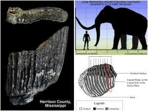
The last interglacial of the Pleistocene epoch, called the Eemian stage, was a period of warm climate that occurred between 129,000 and 116,000 years ago. At the height of this interglacial stage, temperatures were a few degrees higher on average than that of today and sea levels were approximately 25 feet higher than that of today. This created the geologic feature of a coast-parallel marine terrace bordering the Mississippi Sound. Our new geological maps depicts this as the Pamlico Terrace.
As the last interglacial ended and the next glacial cycle began, sea levels fell drastically. At the height of the Last Glacial Maximum, some 20,000 years ago, sea levels were some 400 feet lower than are today. Mississippi then had significantly more land mass due to part of the shelf being exposed. The environment would have consisted of broad coastal meadows dissected by coastal streams in a climate somewhat cooler than that of today.
Now buried beneath the waters of the Mississippi Sound, this ice-age environment would have been teaming with a rich abundance of Pleistocene megafauna. Large mammals such as herds of horses, giant bison, saber-toothed cats, American lion, giant ground sloths, tapirs, and elephant relatives such as mastodon would have occupied this lost world. Also Paleoindian, the ice age hunters that were the first people to call Mississippi home, would have found a bounty of game on this land now buried beneath the Gulf waters.
Evidence from these lost ice age coastal lands comes largely from fossils and artifacts better preserved and discovered in other places along the Gulf, particularly in Florida and Texas. We can only assume, based on those records, that Mississippi was once much the same during that time. That is until an important fossil find made last weekend by Cole Moody, wading at low tide in Harrison County.
Cole found, not one but two, fossil fragments of a Columbian mammoth. His discovery being the first (and the second) record of mammoth for our Mississippi Gulf Coast region. This exiting find is extremely significant, to say the least! Because mammoths are grazers, they inhabit specifically grasslands environments. This is unlike their cousins, the mastodon, who are browsers and can inhabit a wide variety of environments.
This fossil gives are State Survey geologists a much better understanding of the ice-age landscape now lost beneath the sea. The discovery of mammoth remains paints a picture of ice-age grassy coastal meadows bordered by woodland corridors occupied by streams.
This last glacial cycle ended some 11,700 years ago as the last of the continental glaciers melted and sea levels began to rise to the coastline that we see today, only some 5 to 8,000 years ago. The fossil remains of the Columbian mammoth were buried in the Pleistocene meadow soil, now drowned by the Mississippi Sound. The fossils were then likely re-exhumed from the sea bed by strong storms and ocean currents. The fossils were quickly colonized by sea life on the modern sea bed as the mammoth tooth fossils are now encrusted with the remains of bryozoans, barnacles, corals, and oysters.
Cole’s fossil Columbian mammoth tooth finds were confirmed and documented by MDEQ’s State Survey scientists studying the geology of the coastal region and reposited in the Mississippi Museum of Natural Science’s paleontological collections for further study.
Ancient Apex Predator Discovery
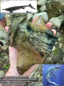 The warm tropical late Cretaceous seas that once covered our entire state up until around 66 million years ago were teaming with an abundance of marine life. While the dinosaurs ruled the land, large sharks and giant marine reptiles ruled the world’s oceans. The evidence for this past world can be found by the diversity of fossilized remains that litter the Cretaceous outcrops of northeast Mississippi.
At the end of the Cretaceous period an environmental catastrophe occurred that not only wiped out the dinosaurs, this extinction event killed off 75% of all life on earth, including sea life. It is thought that a meteorite struck the Gulf of Mexico causing this event and ending the Mesozoic era.
MDEQ’s Mississippi Geological Survey scientists map and study the geology of our state and reconstruct the environmental history of our planet from the evidence they find in the various layers that make up the land. One of the areas our scientists are studying by mapping is near Starkville as they are creating a geological map of the Bluff Lake 7.5 min. quadrangle area. This includes large portions of the Noxubee Wildlife Refuge which encompasses parts of the Flatwoods and Black Prairie physiographic regions. As geology is the basis of the environment, the underpinnings of the Prairie region are the fossiliferous chalky limestone of the Cretaceous seas and the Flatwoods are dominated by the clays of the environment that followed the extinction event that killed off the dinosaurs.
To study and define the three dimensional framework of the distribution of geologic layers to make a geologic map, our State Survey geologists visit exposures (called outcrops) to collect rock/sediment and fossil samples. Earlier this week while visiting an outcrop of the late Cretaceous Prairie Bluff Formation beneath a bridge on the Bluff Lake quadrangle our Survey Scientists came across a very large fossil vertebra of a giant sea lizard called a mosasaur.
Mosasaurs were a diverse group of marine lizards that inhabited various ocean environments of the Late Cretaceous period. These animals lived at the same time as Tyrannosaurs rex, Velociraptor, and Triceratops.
Mosasaurs were fast and very agile swimmers. They were highly adapted to hunting in the late Cretaceous seas. They sported jaws full of up to 60 dagger-like sharp pointy teeth that were curved inward, with additional rows of teeth at the roof of the back of their mouths to help secure larger prey. Mosasaur’s teeth were frequently lost and replaced while hunting fish, swimming shellfish called ammonites, other marine reptiles, and likely each other.
Mosasaurs were sea dragons both large and small and were truly the apex predators dominating the various environments of the seas of this time. While the dinosaurs ruled the land, these Mesozoic era oceans were likely the most dangerous of any time in the entire history of our planet.
The mosasaur vertebra our State Survey scientists found was from a true giant! It belonged to a species known as Mosasaurus hoffmannii. M. hoffmannii was one of the largest and also one of the last of the mosasaurus living during the terminal Cretaceous at time known as the Maastrichtian stage. M. hoffmannii could reach lengths of up to 50 feet and likely weighed over 20,000 pounds, making it one of the most formidable marine predators to ever swim in our planet’s oceans. The vertebra found by our scientists represents one of the largest M. hoffmannii ever recorded in Mississippi and was deposited into the state’s paleontology collections at the Mississippi Museum of Natural Science, in Jackson.
Mosasaurs, like M. hoffmannii along with the dinosaurs, went extinct at the end of the Cretaceous period. The evidence of this is that their fossils are not found in any of the younger Paleocene age sediments that lie above the Cretaceous sediments in our mapping area or anywhere else in he world above this geological time boundary.
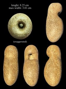
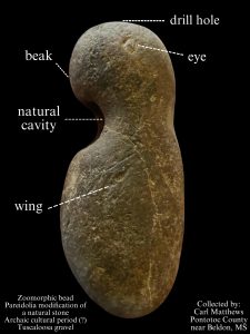
Naturally Owl-Shaped Chert Gravel Pebble
Pareidolia is a common human experience to see meaningful patterns, images, or shapes in random unrelated or meaningless stimuli such as seeing shapes of animals, faces, or other objects in cloud formations. Some people seem to have a much stronger tendency for this ability than others do.
One of the most common forms of pareidolia is seeing patterns and objects in rocks. Because of this, it is one of the most common things our MDEQ State Survey scientists encounter when working with the public on rock/fossil/artifact identifications. Our scientists often field inquiries about possible fossil bones & teeth, artifacts such as arrowheads, or even supposed carvings of faces or animals in rocks that people have found that ultimately turn out to be just natural, curiously shaped stones.
This week our survey geologists received a particularly interesting inquiry for a rock identification from the Union County Heritage Museum in New Albany, Mississippi. The specimen was found in a creek close by a known prehistoric archaeological site by Carl Matthews near Beldon in Pontotoc County, Mississippi.
The object was indeed an ancient prehistoric Native American artifact modifying from an otherwise natural stone. The artifact was made from a chert gravel pebble exhibiting a natural cavity in the center of it. The artifact was manufactured from Tuscaloosa gravel that can be found locally in northeastern Mississippi. The naturally-shaped stone undoubtedly already must have appeared to have looked much like the owl motif that would have been familiar to the artist of a particular time period in our state’s prehistory. It is one that is commonly seen in the zoomorphic lapidary bead industry specific to the middle to late Archaic indigenous cultures here in the southeast.
The owl represented an important symbol for the archaic cultures of the southeast United States, because of its widespread depiction in the complex lapidary industry of these hunter-gather cultures. Many of the owl depictions from this time period are also combined with features of other types of animals. This makes for a wide variety mythical creatures that archaeologists have interpreted as the owl themselves being thought of as a shape-shifting mystical animal.
This chert gravel pebble was modified into a an owl bead by drilling a hole on one end to intersect the preexisting natural hole. Additionally, to complete the bead to look like other similar examples prevalent from this ancient cultural lapidary tradition, an eye and a wing were added by incising the artifact on just one side.
The ancient lapidary industry is a highly-technical artistry that likely developed out of the earlier Benton culture of Northeast Mississippi during the Middle Archaic period. It likely spread westward into the alluvial plain of the Mississippi’s Delta region, culminating with the Late Archaic Poverty Point culture found on ancient archaeological sites preserved in Mississippi and Louisiana. These ancient lapidary traditions, along with the discovery of ceremonial earthworks in our archaeological record from this time period, have forced a scientific re-thinking of the cultural development, widespread symbolism, and the formation of regional collective identities in hunter-gatherer societies. This type of tradition and art is something which is was once more thought to be associated with the development of a more sedentary society that was dependent on an agricultural lifestyle.
This ancient Native American artifact that Carl Matthews discovered is likely some 5,000 years old and is indeed highly unique and unusual. This is because it distinctly was created out of a fairly clear instance of pareidolia and expediently modified to depict the more classical zoomorphic owl motif found in the ancient middle to late Archaic cultural lapidary traditions.
King Helmet Snail in Harrison County
At the height of last glaciation cycle of the Pleistocene epoch, some 20,000 years ago, the Mississippi Gulf Coast was drastically different than it is today. With much of our planet’s water locked up in ice, sea levels were some 400 feet lower than they are today, exposing a good portion of the continental shelf. The courses of the Pascagoula River, Pearl River, and even the mighty Mississippi River had many more miles of land to traverse to empty into the Gulf of Mexico than they do today.
At the close of the Pleistocene epoch, some 11,700 years ago, the North American glaciers made their final retreat into the Arctic. As sea levels rose along our coastline to their present day height, during the early Holocene epoch some 8,000 years ago, our beaches faced the open waters of the Gulf of Mexico. This persisted until long shore currents carried sand from the mouth of coastal rivers to eventually build our barrier islands that protect our coastlines from a heavy surf and storms.
Geologic mapping by MDEQ’s State Geological Survey scientists is on going in the Mississippi’s coastal areas to understand the natural resources and the geologic history that created this unique area of our state. The important work is being conducted through funding by the cooperative USGS StateMap grant program.
Much is learned by our Survey scientists through the studies of stratigraphy by outcrop investigations, test hole drilling, geophysical well log analysis, and geomorphology using bare earth Lidar interpretations. Very little fossils remains exist to help fill in some important details to piece together the ancient past and the evolution of our Mississippi Gulf Coast.
Late last month our MDEQ’s State Geological Survey’s mapping scientists gave a lecture at the Mississippi Academy of Sciences in Biloxi on our current research based on a discovery by University of Southern Mississippi marine biology student, Cole Moody. Cole had been collecting marine fossils from a previously unknown site along the coast in Harrison County, not far from the USM campus. Cole had recently brought his finds to our scientists attention which included a number of fossil manatee ribs & shark teeth, mollusk shells, marine ichnofossils, and fossiliferous sandstone (called beach pavements) that he had collected. A field team was then assembled by MDEQ and guided by Cole, to further explore the fossil site to make a representative collection. The team also included Mississippi State University Coastal Research & Extension Center Associate and avocational paleontologist Kristi Gay.
Today’s Fossil Friday brings us an extraordinarily rare find for Mississippi. It is of an exceptionally-preserved fossil snail shell known as a King Helmet (Cassis tuberosa) as it was found in-situ by Cole. This large gastropod is not found in the Mississippi Sound today but can be seen in the tropical waters of southern Florida, Mexico and the Caribbean.
The exceptional diversity of mollusks shells and marine vertebrates in the Harrison County fossil bed, along with the beach pavement sandstones, tells an important story of a specific environment, not that long ago, but one quite different than exists there in Mississippi today.
This Harrison County fossil assemblage is comparable to an early to mid-Holocene fossil assemblage that was once discovered through dredge spoils deep beneath New Orleans. It was described as an off-shore barrier bar that was later buried by the encroachment of the Mississippi River delta, building land out into the Gulf of Mexico.
At the close of the Pleistocene epoch, sea levels rose rapidly. The Mississippi River carried a massive amount of sediment, building distributary channels out into the Gulf during the Holocene epoch and through to today. Our Mississippi coastline and its ecosystems have naturally changed dramatically during this time by the influx of freshwater, building of the barrier islands, and changes in ocean currents while creating the Mississippi Sound. This amazing discovery of the Harrison County fossil site gives our MDEQ State Geological Survey scientists an important opportunity to understand and interpret how Mississippi’s coastal environments have changed throughout this period of our more recent geologic past.
Mississippi’s Most Complete Dinosaur Fossil
 When dinosaur fossil remains are discovered here in Mississippi, a diverse team of scientists is deployed to collaborate and study various aspects of the find. In this case, Mississippi’s most complete dinosaur fossil to date. The remains include a large adult hadrosaurid, a plant-eating dinosaur, along with remains of a juvenile fledgling! Studying and taking detailed measurements of the bones and comparing it to other known similar dinosaur finds throughout the world is a long process. It gives a great amount of information and detail about the individual. It also helps determine where the animal fits on the evolutionary tree. Studying the regional placement of the find in the geologic section helps us to bracket the sedimentary beds it was found in and the relative age of the fossil remains. More detailed studies of the sedimentary layers and other fossils at the excavation site helps us to determine, in great detail, the depositional environment and ecosystem the dinosaur once lived and came to rest in. Sediment samples taken at the fossil site can contain millions tiny plant spores and other microscopic remains. This fossil palynology helps to reconstruct the botanical aspects of the dinosaur site and past climate in unprecedented detail. An amazing poster on the palynology of the dinosaur fossil site was delivered by our Delta State University’s team, Dr. Nina Riding and Olivia Pharr, earlier this month at the Geological Society of America conference in Arkansas. It’s really amazing to imagine that these are actual 82 million year old plant spores and algal cists that once occupied the land with a Mississippi dinosaur! At the at the last week at the Mississippi Academy of Sciences conference last in Biloxi our USM team’s Dr. Alyson Brink and Derek Hoffman gave a lecture on the morphometrics of the adult individual dinosaur from the site and where it might fit in evolutionary context. To see a high resolution version of the image, click here.
Wilhelm Heard’s Crinoid Calyx
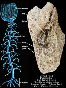 Our MDEQ, State Survey geologists had a great day last Saturday participating as experts on hand to identify rocks, fossils, and artifacts for the public at the Mississippi Museum of Natural Science’s 22nd annual Fossil Road Show. The show offers the public a chance to engage with and have their treasured finds identified by a panel of expert scientists, see educational paleontological exhibits, and to participate in a host of earth science activities geared to enthusiasts of all ages. Our State Survey scientists have been a staple at the annual program since its founding.
Most people in our state get introduced to rock and fossil collecting at a very young age by noticing the variety of patterns and colors in the stones of our local gravels. Many of the colored stones are varieties jasper, quartz, carnelian, and agates. Most of the regular patterns in the rock are indeed ancient marine fossils! They are the preserved remains of invertebrate animals that are hundreds of millions of years old. Most of the fossils found in our chert gravel lived at a time called the Paleozoic era, long before the day of the Dinosaurs.
The most common chert gravel fossil finds are the remains of animals called crinoids. Crinoids are commonly referred to as “sea lilies” but are not at all plants. They are animals related to starfish and sea urchins. Crinoids are still alive today and only inhabit rare environments in our oceans, but were once much more common in our geologic history. Their numerous round and oval column segments are typically found preserved and resemble “Cheerio’s”. To find a whole or even part of a calyx is a really rare treasure. Even rarer are fossil crinoid specimens with their arm segments and other parts preserved. This is because the animal is made up of numerous plates, called ossicles, that are rarely preserved intact. When the animal dies, it typically designates into its numerous individual ossicles. Crinoids were once so abundant during the Paleozoic era that sediments of the sea floor were commonly made up entirely of their ossicles.
Today’s #fossilfriday features the rare find of an ancient, largely complete, crinoid calyx found in chert gravel by Wilhelm Heard in Copiah County, MS. Wilhelm, a six year old inspiring paleontologist, brought his collection of gravel rock and fossil finds, which included this rare fossil, into the museum’s Fossil Road show last week where it was identified by one of our MDEQ, State Survey geologist.
Wilhelm’s crinoid calyx fossil formed when silica-rich groundwaters replaced great portions of ancient limestones that the fossil was entombed in. The fossil dissolved away as the limestone surrounding it was replaced with the silica mineral, chert. This fossil left a perfect, permanent impression in the rock, leaving behind the details of the crinoid including the calyx, arms, and portions of the stalk. This type of fossil cavity in the rock is called a fossil mold. The fossil mold was later exposed when the rock broke naturally, revealing once again the impression of the ancient animal after being locked in the stone for millions of years.
Wilhelm’s gravel fossil was not originally formed here in Mississippi. It was brought here naturally, over millions of years by ancient courses of rivers that drained ancient Paleozoic bedrock up in the mid-continent. The rivers carried gravel long distances across Mississippi along their courses, leaving behind extensive chert gravel deposits. This spectacularly-preserved crinoid fossil is truly an ancient treasure discovered in our Mississippi chert gravels.
“Living Fossil” Found in the Delta National Forest
Echoes from earth’s deep history are all around you in nature and are hiding in plain sight. Over millions of years of geologic time, plants and animals have found infinite ways to survive in the constantly changing world. These adaptations not only better suited plants and animals to habitats, but also were in response to other living things that they shared the environment with around them. Many of characteristics we see today in both plants and animals were in response to things that are now long since extinct.
Plants and animals have evolved very clever ways to attract, warn off, and to protect themselves from other plants or animals. A great example this are the infamous “living fossils”, the garfishes (Lepisosteidae) that can be found abundantly in our freshwaters streams and rivers of Mississippi today. Garfish developed an armor of thick bony scales to protect themselves from the predators that once lived during the days of the dinosaurs. This adaptation from the Triassic period served them well as they remain virtually unchanged for 240 millions years.
Many plants are also considered “living fossils”. Their flowers, fruits, and seeds were adapted to attract insects and other animals millions of years ago. A great example of this is the pawpaw plant (Asimina triloba) found native in Mississippi. It evolved to be eaten by giant herbivores now long extinct. The large edible pawpaw fruits were favored by mastodon and gomphotheres that lived here since the end of the Miocene epoch. Pawpaw fruits contain undigestible seeds that were spread throughout the forests in and fertilized by the dung of these colossal beasts. The range of the pawpaw plant has been significantly reduced over the last 12,000 years as direct result of the extinction of the elephant relatives that once roamed this region and fed on them.
Plants also develop clever survival strategies to prevent animals from eating them. Today’s #FossilFriday brings us to the Delta National Forest to the formidable-looking spikes that adorn the trunk of the honeylocust tree (Gleditsia triacanthos). This plant’s defense mechanism was photographed by one of our MDEQ, State Geological Survey scientists while in the field in the south Delta region earlier this month. These unusual trees can grow up to 80 feet tall and have clusters of large spike-like thorns on their trunk and lower branches. These spike-like thorns evolved to ward off animals which no longer exist in Mississippi’s bottomland forests. Just like pawpaw fruit, the bark and the leaves of the honeylocust were favored by the American mastodon (Mammut americanum). These ornate displays of thorn clusters on the honeylocust were highly effective in protecting the tree against damage from these giant megafauna herbivores that went extinct at the end of the Pleistocene epoch.
So the next time you are out enjoying nature, consider that many aspects of plants and animals that you observe around you are just reflections of nature’s more ancient past.
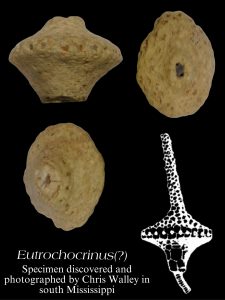
Rare and Unusual Crinoid Calyx Found in South Mississippi Chert Gravel
Cauliflower cherts, which also form as geodes, can commonly be collected from our chert gravels found along south Mississippi creeks and gravel deposits. Typically they can be recognized as a stone with an exterior consisting of chert or chalcedony and the inside being filled with the mineral quartz. They originated from Paleozoic age bedrock limestones in the mid-continent of North America. They were carried down here to Mississippi by ancient rivers as a constituent of their sediment bed-load.
Many of these cauliflower chert geodes once originated as ancient marine invertebrate fossils, such as brachiopod shells and crinoid calyxes. Once they were buried and entombed in rock, they became the nucleus for silica mineral growth from mineral-rich fluids within the limestone. This type of fossil replacement makes a mineral copy of the fossil,
called a fossil pseudomorph.
In most instances the fossil became badly distorted by crystal growth during the mineralization process of the fossil. They also often remained hollow inside until mineral-rich waters deposited quartz growth along the walls of the fossil cavity in the rock. Rarely do the delicate features of the fossil preserve well enough to accurately identify it.
Today’s #fossilfriday is a south Mississippi gravel find courtesy of Chris Walley of Wayne County, Mississippi. This amazing find of a nearly complete crinoid calyx measures about 2 cm in diameter. The crinoid fossils prolific in our Mississippi chert gravel are the remains of ancient marine creatures that are much older than the days of the dinosaurs.
Crinoids are commonly referred to as “sea lilies” but are not plants. They are animals related to starfish and sea urchins and are still alive in our oceans today. Crinoids are one of the most common fossils found in our gravel. Most typically the segments of their round or oval column (called ossicles) are preserved. To find a whole or even part of the calyx is a really rare treasure. This is because that part of the animal is made up of numerous, much smaller plates (also called ossicles) that are rarely preserved intact together .
At first, Chris’s specimen was believed to be possibly a Native American stone lapidary artifact. It was identified earlier this week by our MQEQ State Geological Survey Geologists as a natural Mississippi fossil discovery. Chris’ crinoid calyx fossil retains much of its overall morphology. Though the individual plates can’t be deciphered due to its cauliflower chert preservation, much of the detail of the ornamentation around the periphery of the calyx is quite recognizable. This amazing find is comparable to the crinoid genus Eutrochocrinus, from the Mississippian period (approximately 360-323 million years old).
A Superb-owl Weekend!
 What started out as an accidental misspelling on a meme about the Super Bowl a few years ago that went viral, has now morphed into a yearly phenomenon on social media for owl lovers and other bird enthusiasts around Super Bowl weekend.
Owls, like all other birds, are closely related to dinosaurs. Owls are from the biological order Strigiforms and have a fossil record dating back to the later part of the Paleocene epoch, some 55 million years ago. They are a highly unusual group of carnivorous birds that are steeped in mystery because of their distinctive appearance and nocturnal behavior.
An owl’s feathers are adapted for silent flight and their large eyes and broad head are adapted for both binocular vision and stereo-adapted hearing. Their vocalizations vary highly between species but are distinctive and can often be heard over great distances.
Throughout human history owls have held great symbolism across cultures. Today in many western cultures they are seen as a symbol of scholarship and wisdom, a link to Ancient Greeks traditions. In modern Native American traditions, the owl symbolizes a wide spectrum of meaning from spirits of strength and protection to harbingers of death and evil. While the owl remains iconic, its meanings to indigenous people has undoubtedly changed throughout history.
Today’s #FossilFriday brings us into the realm of archaeology, to an important find from Chickasaw County near Houston, Mississippi. This exquisitely-crafted 5,000 year old zoomorphic bead from the Archaic Cultural period in Mississippi depicts an owl perched on a stump. This amazing indigenous art piece pre-dates the Egyptian pyramids and was brought in to the Union County Heritage Museum by historian Julian Riley. It was photographed earlier this month following a guest lecture at the museum on our state’s deep archaeological heritage that was given by one of our MDEQ’s State Geological Survey scientists.
The owl represented an important symbol for the archaic cultures of the southeast United States, because of its widespread depiction in the complex lapidary industry of these hunter-gather cultures. Many of the owl depictions from this time period are also combined with features of other types of animals. This makes for a wide variety mythical creatures that archaeologists have interpreted as the owl themselves being thought of as a shape-shifting mystical animal.
This ancient lapidary industry is a highly-technical artistry that likely developed out of the earlier Benton culture of Northeast Mississippi during the Middle Archaic period. It likely spread westward into the alluvial plain of the Mississippi’s Delta region, culminating with the Late Archaic Poverty Point culture found on ancient archaeological sites preserved in Mississippi and Louisiana. These ancient lapidary traditions, along with the discovery of ceremonial earthworks in our archaeological record from this time period, have forced a scientific re-thinking of the cultural development, widespread symbolism, and the formation of regional collective identities in hunter-gatherer societies. This type of tradition and art is something which is was once more thought to be associated with the development of a more sedentary society that was dependent on an agricultural lifestyle.
Julian’s zoomorphic owl bead was likely made and expertly drilled by a designated professional artisan in the community. The red-colored stone was an important color for this style of bead. Many of these amazing archaic period zoomorphic beads were made from red jasper, common to the chert gravels of western and south Mississippi. This northeastern Mississippi example is crafted from a limonitic claystone, a common, red-colored stone more local to the area it was found.
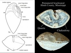 Rockhounding in Mississippi Gravel
Sedimentary banded agates and marine fossils from the Paleozoic era (541 million years ago to 252 million years old) are treasured finds while rockhounding in Mississippi gravel.
Our agates formed when small cavities, dissolved in limestone, were filled with silica-rich groundwater. Over millennia alternating growths of quartz and chalcedony precipitated from the mineral-rich ground water. As the host limestone was exposed at the earth’s surface and weathered away, it left the more chemically-resistant banded agate behind.
Similarly, this same silica-rich groundwater also replaced great portions of the limestones, perfectly preserving the diversity of fossils they contained.
In today’s #FossilFriday, we have a great example of a phenomenon where an ancient marine invertebrate fossil is also an agate. It was discovered by Kyle Furlow in Hinds County, Mississippi and identified this week by our MDEQ’s Survey Geologists at the Office of Geology.
The fossil is of a type of invertebrate called a Pentamerid brachiopod. Brachiopods were once a diverse group of animals in the ancient warm, shallow seas during the Paleozoic era. They dominated a niche similar to that of a modern clam. Though they are actually unrelated to clams and other mollusks, their relatives still inhabit different environments of the world’s oceans today.
This brachiopod fossil became an agate after the fossil shell dissolved away in the limestone, leaving a void in the rock consisting of a perfect impression of the shell. This is called a “fossil mould”. When silica-rich ground water invaded the fossil void, likewise it precipitated quartz and chalcedony mineral layers creating a solid cast of brachiopod called a “fossil pseudomorph”.
The gravel fossils and agates were brought to Mississippi here naturally over millions of years, as ancient courses of rivers drained the bedrock region of the mid-continent. They carried gravel along its way across Mississippi to drain into the Gulf of Mexico, leaving behind the chert gravels that can be found in many parts of the state. This spectacularly preserved brachiopod agate/fossil is just one of many of the ancient treasures that can be found in our Mississippi chert gravels.
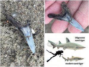 Sand Tiger Shark Fossils in the Bucatunna
The Sand Tiger shark (sharks of genus Carcharias) are medium to large sharks that have inhabited the warm waters of the northern Gulf of Mexico since the times of the dinosaurs, first showing up in our fossil record during the Cretaceous period nearly 100 million years ago. They, like other sharks, are cartilaginous fish, so they are typically only known from their teeth left behind in the fossil record.
Sand Tiger sharks (Carcharias) are neither tiger sharks nor nurse sharks as their common name suggests. They have long streamlined bodies and sharp teeth for feeding on fish, squid, and crustaceans. Despite their formidable appearance, they are popular public attractions in large aquariums due to their relatively docile nature and that they do quite well in captivity.
Their teeth can be found in quite abundance in near-shore environments throughout the fossil record in Mississippi because they can lose hundreds, if not thousands, of their teeth which are quickly replaced during the lifespan of the shark. Their anterior teeth are easily identified by their long, slender appearance bordered by a pair of small accessory cusps.
Today’s Fossil Friday takes us back some 30 million years ago to the Oligocene epoch to marine fossiliferous outcrops in central Mississippi. Last week our State Geological Survey scientists at MDEQ were exploring fresh exposures of the Bucatunna Formation in Smith County, Mississippi along with the MDWFP’s paleontology program at the Mississippi Museum of Natural Science when they came across an exceptionally large fossil sand tiger tooth.
Some of the largest sand tiger sharks that ever lived are found in the fossil record during this important time in earths history as our planet’s climate began to cool. These sand tiger sharks from the Oligocene epoch could reach lengths of up to 16 feet as evidenced by the find of rare partial fossil skeleton found in Germany. In contrast their modern relatives in our Gulf of Mexico waters today only grow to about six feet but can reach lengths of up to 10 feet.
The Bucatunna Formation is part of the Vicksburg Group and marks the last time the seas rose over much of Mississippi. Its outcrop is marked by a narrow band of rugged hills underlain by fossiliferous limestone and sandy marls that stretches from Vicksburg, through Byram and Brandon, eastern Smith County along Hwy 18, and East through of Waynesboro along Hwy 84 to the Alabama line.
The deposits of the Vicksburg group are famous in the scientific community for their diversity and exceptional presentation of marine (and rare terrestrial) fossils. These limestone outcrops have also been an important economic resource throughout our states history. At one time limestones of the Vicksburg Group were utilized for cement manufacturing and dimension stone in Mississippi, but now it is primarily mined for agricultural limestone. Also, thin beds of exceptionally pure bentonite can be found in between the beds of limestone. This important economic resource is actually derived from ancient volcanic. This water-lain ash originated from volcanic eruptions in western North America and was used by our scientists for radiometric dating to arrive at the exact age of these deposits.
Today’s featured fossil was found in is the uppermost division of the Vicksburg group, the Bucatunna Formation, which primarily consists carbonaceous clay. Reaching up to 45 feet in thickness, the Bucatunna Formation was deposited in an ancient brackish water environment as the sea levels began to fall. It was deposited in a similar environment to that of the Mississippi Sound and our coastal estuaries of today. The clays of the Buccatunna Formation have been mined and exported from Mississippi for use as a nutrient-rich fertilizer in banana plantations in the Caribbean and South America. These carbonaceous clays also hold the potential of an economic resource for rare earth elements.
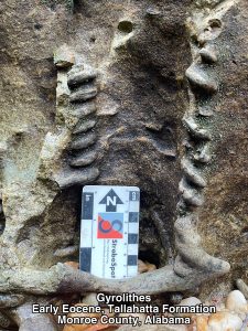 A Twist in Time
Fossils are the ancient remains of plants and animals preserved in the stratigraphic record. They typically consist of things like bones, shells, and teeth that are valuable clues about our geologic past found in the field by our MDEQ state survey scientists as they map and study our state geology and natural history.
There are also other types of fossils our State Survey geologists commonly encounter in the field called ichnofossils, also referred to as “trace fossil”. Ichnofossils are things like footprints, burrows, and feeding traces that animals left behind. Ichnofossils are an important part of interpreting our geologic record as their presence can greatly enhance our knowledge of past environments and depositional settings, especially where few other types of fossils are present. Additionally, some animal remains are not conducive to fossilization, therefore their ichnofossils are all we know of their existence in the geologic record. Each type of ichnofossil gives some level of detail of how animals lived, fed, and moved throughout their environment.
Our geologic outcrop belts extend well beyond the state lines in Mississippi with most of the geologic formations extending across the entire northern Gulf of Mexico coastal plain. Because of this, it is important for our State Survey geologists to understand the perspective of our state’s geology within the broader context of the region, often prompting them to visit and study geologic outcrops in neighboring states.
Today’s Fossil Friday brings us to Tallahatta Formation of the Lower Eocene epoch (approximately 50 million years old). The Tallahatta Formation can be found in an arcuate band of sandstone, siltstone, siliceous claystone, and orthquartzite forming an aggressive rocky, hilly terrain from DeSoto County, south through Grenada County, and east through Lauderdale County in Mississippi known as the “Tallahatta cuestas”. These deposits once formed within an ancient warm shallow sea towards the Alabama state line and grade into more deltaic deposits through north Mississippi towards the Tennessee line. They are sparsely fossiliferous in Mississippi but are quite increasingly fossiliferous into Alabama.
Most of what we know about the terrestrial/deltaic environment of the Tallahatta Formation comes from leaf fossils in the northern and central outcrops in Mississippi. Rare mollusk shell fossil impressions and numerous burrows of ‘thalassinidean’ shrimp called Thalassanoides mark the shallow marine beds of the Tallahatta Formation in the eastern part of the state.
In a recent visit to Monroe County, Alabama to study the Tallahatta Formation in Alabama, our State Survey geologists found an interesting manifestation of the fossil burrows attributed to the marine thalassinid shrimp. These helical burrows are called Gyrolithes and represent a significantly different habit of this burrowing shrimp. This is likely related to a difference in the environment they occupied which includes sediment, water depth, and oxygen levels. The ichnogenus Gyrolithes actually dates back to the Cambrian period, but the helical structures attributed to this ichnogenus were undoubtedly made by different animals over the course of geologic time. Gyroides in the more ancient geological record are attributed to polychaetes, while the ones represented in Mississippi’s geology are almost certainly all related to burrowing shrimp like those that can be found in the sediments of the estuaries along the Mississippi Gulf Coast today.
The environments ideal for these burrowing shrimp to make helical structures likely helped them to protect themselves by making access difficult for predators that might try to invade their burrows.
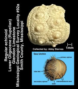
Smith County Sea Urchin
Sea urchins are echinoderms, regular echinoids that live on the sea bed and inhabit a wide variety of environments, temperatures, and water depths in today’s oceans. They can inhabit tropical to arctic waters, from the intertidal portions of the coastline to great ocean depths of more than 16,000 feet. They are globular in shape and their hard mineralized exoskeleton possess a 5-fold symmetry. Sea urchins are covered in club-shaped spines that act as protection and along with their tube-feet aid in locomotion as they graze mainly on algae along the sea floor. They are commonly referred to as “sea hedgehogs” because of their spiky outer appearance and the word ‘urchin’ In fact, comes from an old word for hedgehog. Their fossils serve as a very important part in the interpretation of the paleontological record with their ancestors dating back to the Ordovician period, some 450 million years ago.
In Mississippi’s fossil record, regular echinoids are rarely found intact and evidence of their presence is typically only known from disarticulated fragments such as their plates and spines. This is because most of the geological marine deposits they are found in here in Mississippi were formed in relatively high-energy shallow marine environments that tended to break apart and scatter their remains after death.
Their cousins, the irregular echinoids, have a two fold symmetry and are often heart-shaped, domed, or relatively flat. Irregular echinoids include heart urchins, sea biscuits, sea cookies, and sand dollars. Irregular echinoids live and feed in the sediments of the seabed, not on top of it like their regular echinoid cousins. Irregular echinoids are also coated with spines, but their spines have evolved into much smaller more hair-like structures. Because of their burrowing habit, irregular urchins are found intact much more abundantly than their regular urchin counterparts in our Mississippi fossil record. This makes them much easier for our scientists to readily identify them in the field than that of the mix of individual plates and spines typically left behind by regular echinoids.
Today’s Fossil Friday brings us to an important regular echinoid find in the uppermost beds of the lower Oligocene (Rupelian) Glendon Limestone from Smith County, Mississippi. This tiny, delicate, nearly 30 million years ago old fossil sea urchin was discovered by Mississippi State University student Abby Starnes in Dr. Renee Clary’s geology class during a field course lead by our MDEQ’s State Survey geologists earlier this fall. The fossil sea urchin was identified by our survey scientists and donated by Abby earlier this week to the paleontological collections repository at the Mississippi Museum of Natural Science. This regular echinoid is just a partial specimen but it is quite a significant find because it is now the most complete regular echinoid we have now in the state’s collections representing the fossils of the Glendon Limestone and of the Vicksburg Group from Mississippi.
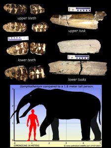
Mississippi’s Gomphotheres
Mississippi was home to at least three types of Proboscidean, relatives of modern elephants. The two most familiar are the Columbian mammoth and the more common American mastodon. The mammoth was the closest relative of modern elephants and a late arrival on the North American continent, sometime during early Pleistocene (some 1.5 million years ago). Mammoths migrated from Eurasia, while the mastodon has far deeper roots in North American geologic history going back to the late Miocene (approximately 8 million years ago). Little is known about our third ancient elephant relative from Mississippi’s fossil record, the even stranger-looking Gomphotheres.
Gomphotheres first appeared in the fossil record in Africa during the Oligocene epoch, some 30 million years ago and then dispersed into North America during the late Miocene epoch from Eurasia. Gomphothere were quietly different in appearance from mammoth and mastodon but they shared similar characteristics in their teeth with their closer cousins, the mastodon. While mammoth shared similar teeth characteristics with their cousins, the modern elephants. The early North American Gomphothere had distinctive features such as longer jaws than their mastodon relatives, and shovel-shaped lower tusks and short upper tusks.
Today’s Fossils Friday brings us to the find of the earliest record of Gomphothere fossils from Mississippi, Gomphotherium simplicidens. It was discovered by avid artifact and fossil Wayne Harvard in northwestern Amite County and was the first and now oldest record we have for Gomphothere in Mississippi. This extraordinarily rare find is from the late Miocene Pascagoula Formation and includes a complete dentition and portions of both upper & lower tusks of an individual.
Little is known about the fossil record of the late Miocene geology of southwest Mississippi, making Wayne’s find quite significant for a number of reasons. The discovery helps confirm the age of the deposits it was found in, understand the depositional environment, and also help to correlate it to other similar age deposits found elsewhere in North America. This all in addition to being the first and earliest record of Gomphothere in the state.
Two other teeth are now known from a much later Gomphothere, called Cuvieronius. They were both found in the late Pleistocene deposits of the Mississippi River. These much later Gomphothere shared Mississippi’s ice-age landscape with both the American mastodon and the Columbian mammoth.
Gomphotheres also migrated into South America some during an even that is known as the Great American Interchange. This is when the isthmus of Panama land bridge opened up between the two continents around 2.7 million years ago, allowing plants and animals to freely disperse between the two land masses that were once isolated for tens of millions of years. While Gomphotheres numbers dwindled during the Pleistocene epoch in North America because they were being replaced by the more successful mastodon and mammoth, they flourish in the warmer environments of South and Central America.
At the end of the Pleistocene epoch, all three Proboscidean genera became extinct in Mississippi (mammoth, mastodon, and gomphothere) along with the rest of the iconic ice-age megafauna. Though, archaeological and paleontological evidence suggest that Gomphothere may have indeed persisted in South America well into the early Holocene before becoming extinct.
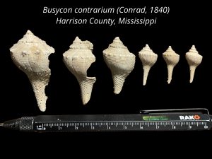
Harrison County Welks Collection
At the height of last glaciation cycle of the Pleistocene epoch, some 20,000 years ago, the Mississippi Gulf Coast was drastically different than it is today. With much of our planet’s water locked up in ice, sea levels were some 400 feet lower than they are today, exposing a good portion of the continental shelf. The courses of the Pascagoula, Pearl, and even the mighty Mississippi River had many more miles of land to traverse to empty into the Gulf of Mexico than they do today.
At the close of the Pleistocene epoch, some 11,700 years ago, the North American glaciers made their final retreat into the Arctic. As sea levels rose along our coastline to their present day height, during the early Holocene epoch some 8,000 years ago, our beaches faced the open waters of the Gulf of Mexico. This persisted until long shore currents carried sand from the mouth of coastal rivers to eventually build our barrier islands that protect our coastlines from a heavy surf and storms.
Geologic mapping by MDEQ’s State Geological Survey scientists is on going in the Mississippi’s coastal areas to understand the natural resources and the geologic history that created this unique area of our state. The important work is being conducted through funding by the cooperative USGS StateMap grant program.
Much is learned by our Survey scientists through the studies of stratigraphy by outcrop investigations, test hole drilling, geophysical well log analysis, and geomorphology using bare earth Lidar interpretations. Very little fossils remains exist to help fill in some important details to piece together the ancient past and the evolution of our Mississippi Gulf Coast.
Earlier this week our State Survey’s mapping scientists met with a University of Southern Mississippi marine biology student, Cole Moody who had been collecting marine fossils from a previously unknown site along the coast in Harrison County, not far from Campus. Cole had recently brought to our scientists attention a number of fossil shark teeth, mollusk shells, marine ichnofossils, and fossiliferous sandstone (called beach pavements) that he had collected. A field team was assembled, guided by Cole, to explore the fossil site to make a representative collection. The team also included Mississippi State University Coastal Research & Extension Center Associate and avocational paleontologist Kristi Gay.
Today’s Fossil Friday exhibits a collection made by the field team of exceptionally-preserved juvenile fossil of the predatory gastropod Busycon contrarium (Conrad, 1840), commonly known as a welks from the fossil-rich site near Long Beach, Mississippi. The exceptional diversity of mollusks and marine vertebrates in the fossil bed, along with the beach pavement sandstones, tells an important story of an specific environment, not that long ago, but somewhat different than exists there today. This Harrison County fossil assemblage is comparable to an early to mid-Holocene fossil assemblage that was discovered through dredge spoils beneath New Orleans. It was described as an off-shore barrier bar that was later buried by the encroachment of the Mississippi River delta, building land out into the Gulf of Mexico.
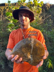 Ammonite Find in Union County
Ammonites are an extinct group of shelled cephalopods, a diverse group of predatory mollusks that are relatives of modern octopus and squid. For over 300 million years of our earth’s history the world’s oceans were teeming with a broad diversity of ammonites.
Finding ammonite shell fossils in the field are very important paleontological resources to mapping geologists. They are excellent time boundary indicators because of their rapid rate of evolution and world-wide distribution in the marine sedimentary record. Because of this they are considered important guide fossils for differentiating and correlating geologic deposits, particularly those from the Mesozoic era. This is especially true for geologic mapping of the late Cretaceous age deposits of northeast Mississippi, an area that was once covered by a warm shallow sea where ammonite fossils along with other marine fossils can commonly be found.
Ammonite species can be determined by a careful study of the complex repeating patterns preserved on their shells called “suture patterns”. These sutures are actually a barrier between chambers in the ammonite’s shell. These chambers were continually added on as the animal grew during its life. These chambers acted much like a swim bladder of a fish to help maintain the ammonite’s buoyancy in the water column. Some ammonites were likely very fast swimmers, making them ferocious predators of fish and maybe even other ammonites. Some scientists suggest that the complexity of the suture in an ammonite’s shell helped to retain more liquid in the chambers, through surface tension, as a way to fine fine-tune their buoyancy as they chased down prey or escaped predators in the open ocean.
Today’s Fossil Friday brings us an example of large fossil ammonite called Sphenodiscus from the Chiwapa Sandstone member of the Ripley Formation. It was collected last month by MDEQ State Survey research geologist, Jonathan Leard, while conducting fieldwork in Union County, Mississippi. Sphenodiscus lived during the early Campanian to the late Maastrichtian (approximately 83.5 to 66 million years ago). It has a beautifully complex suture pattern as highlighted in a drawing overlay on the fossil shell. Sphenodiscus shell was very sleek and hydrodynamic in profile. It likely could swim through the water with significant speed and agility.
Current-swept shallow marine sands that formed the Chiwapa Sandstone in what is now part of Union County were an important environment for Sphenodiscus. It is suggested that the area may have served as spawning grounds for these cephalopods due to the concentrations of their fossil shells that can be found there. Gatherings of ammonites in numbers like this also made them easier prey for large sharks or ferocious mollusk-eating marine lizards, such as the unusual mosasaur Globidens.
Ammonites and their cousins, the nautiloids, lived together in Mesozoic seas of Mississippi until the extinction event that killed off the dinosaurs, along with 75% of all life on earth, at the end of the Cretaceous period. Nautiloids inexplicably survived the extinction event at the end of the Cretaceous while ammonites did not. Nautiloids then flourished in the recovering ecosystems of the oceans during the Paleocene epoch. The Nautilus is the sole living shelled cephalopod swimming the world’s oceans today.
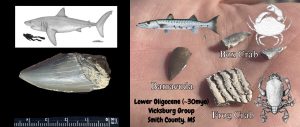
Field Trip Finds
Last Friday, MDEQ’s Office of Geology state survey scientist lead a paleontological joint field trip in Smith County hosting three classes across two institutions, two from Mississippi State University’s Department of Geosciences and one from Jones County Junior College. The field exercise involved a short lecture about the geology, paleontology, and stratigraphy of the limestones exposed in the area that were deposited in the lower Oligocene Epoch, some 30 million years ago. The students were then set free to study the outcrops and collect the diversity of marine invertebrate and vertebrate fossils in the limestone while our survey geologist aided in answering questions and identification of the college student’s finds.
Two special guests scientists participated in field trip: Jun Ebersol-visiting shark expert and paleontologists with the Mcwane Science Center in Birmingham and Dr. Sandy Ebersol- our counterpart directing the geologic mapping program for the Geological Survey of Alabama in Tuscaloosa.
Featured in today’s Fossil Friday are a selection a fossils collected by MDEQ staff from last week’s paleontological field trip. On the left is a crown of the mega-toothed shark, Otodus auriculatus, that was collected by Bailee Ozbirn. Also featured is a collection made by Lindsey Tortorich of well-preserved decapod fossils (a carapace of a frog crab and dactyls from box crabs) along with a fossil fish tooth of a large barracuda.
The Oligocene epoch marks an important inflection point in our planet’s climatic history, transitioning from a greenhouse that persisted since the days of the dinosaurs to an ice house that culminated later with the cyclic glaciations of the Pleistocene epoch. During the Oligocene, ice began forming in the polar regions and the earth began to cool.
The climatic shift directly affected the marine life in the world’s oceans. This can especially be seen in the fossil record of sharks compared to the prior epoch, the warmer Eocene. Shark diversity was heavily reduced because of the cooling, but the size of some groups of sharks increased significantly. This is most notable in the genus Otodus (the largest shark alive at this time was Otodus auriculatus). It was a true giant of the Oligocene seas and was also an ancient ancestor to the infamous and even larger, Otodus megalodon from the Miocene and Pliocene epochs (the largest shark to have ever lived).
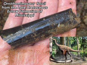 Dinosaur Fossils in Mississippi
Our MDEQ State Geological Survey scientists are often asked, have dinosaurs’ fossils ever been found in Mississippi. The answer is yes! Dinosaurs’ fossils have indeed been found here, but little is known about dinosaurs here compared to the enormous amount of information we have about them from the western United States.
This very limited information on dinosaurs’ fossils we have here in the east, compared to that of the west, is for a number of reasons. First, much of dinosaur age geology at the surface in eastern North America is just from the Cretaceous period, the last period of Mesozoic era. Secondly, during this time there was a shallow seaway that separated the eastern and western halves of North American continent. Thirdly, much of the geology exposed at the surface here, particularly in Mississippi from the late Cretaceous is marine deposits. Therefore, most of the dinosaur fossil finds we have recorded here are just fragmentary remains of carcasses that were swept out to sea and heavily scavenged by sharks and other fish. The more complete fossil record out west is far better studied, and very little scientific attention has been given on studying the dinosaur fossils found here in the southeast.
In Mississippi, the outcrops of our Cretaceous period geology is restricted just to the northeastern part of the state. These formations encompass an extremely fossiliferous set of strata, containing an abundance of the well-preserved remains of invertebrates along with fish and marine lizards such as mosasaurs and plesiosaurs. The remains of flying reptiles called pterosaurs have also been found in these beds here in Mississippi. Dinosaurs such as hadrasaur, dromeosaur, nodosaur, ceratopsian, and even the remains of large theropods (relatives of T. rex) have been found in Mississippi, but only known from isolated bones and teeth.
The lower beds of the Eutaw Formation stand out as containing the most abundant record of fossil remains of dinosaurs in Mississippi. This is best known from studies of outcrops of the Eutaw Formation in the area in and around Columbus, Mississippi. The ancient environment the sediments of the Eutaw Formation formed in were that of an estuary, where the land met the sea. This rich environment preserves the remains of both sea creatures like sharks and crocodiles alongside land animals, particularly dinosaurs. Here, among the rich fossil bone and teeth-bearing deposits are the remains of a specific group very odd-looking dinosaurs called ornithomimosaurs. These are bird-mimicking dinosaurs and were very much ostrich-like in appearance. Ornithomimosaurs were almost certainly completely feathered dinosaurs. Species found in the Eutaw Formation were studied in a recent scientific publication and are described as ranging in size from an ostrich to real giants that likely weighing in excess of 1,700 pounds.
Today’s Fossil Friday brings us to a recent Mississippi dinosaur fossil find from these fossil rich beds of the Eutaw Formation, where a partial toe bone of an ornithomimosaur was discovered. This 84-million-year-old dinosaur fossil was found last month during a field expedition with MDEQ’s Survey Geologist and Mississippi Museum of Natural Science paleontology staff. They were working with the City of Columbus’s city council, grant specialists, parks director, engineers and local advocates on developing a public fossil park for their city. Here an interpreted natural area is planned to be established for the public to explore and collect their own dinosaur age rocks and fossils. Educational materials will also be made available to learn about and identify their ancient Mississippi dinosaur age fossil finds.
Lepidenteron Fossils From the Upper Eocene Moody’s Branch Formation of Mississippi 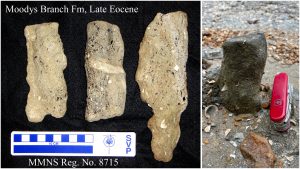
Fossils are the ancient remains of plants and animals preserved in the stratigraphic record. They typically consist of things like bones, shells, and teeth that are valuable clues about our geologic past found in the field by our MDEQ state survey scientists as they map and study our state geology and natural history.
There are also other types of fossils our State Survey geologists commonly encounter in the field called ichnofossils, also referred to as “trace fossil”. Ichnofossils are things like footprints, burrows, and feeding traces that animals left behind. Ichnofossils are an important part of interpreting our geologic record as their presence can greatly enhance our knowledge of past environments and depositional settings, especially where few other types of fossils are present. Additionally, some animal remains are not conducive to fossilization, therefore their ichnofossils are all we know of their existence in the geologic record. Each type of ichnofossil gives some level of detail of how animals lived, fed, and moved throughout their environment.
Today’s Fossil Friday brings us to the upper Eocene epoch in Yazoo County, Mississippi. There in the richly fossiliferous beds of the Moodys Branch Formation, a highly unusual ichnotaxa called Lepidenteron occurs. Lepidenteron is an unbranching burrow without a constructed wall that is lined with the numerous fossil remains of small fish including bones, scales, and otoliths. When these fossils were first encountered by our scientists, they were thought to be fossils known as coprolites. It wasn’t until numerous fossils were found in-situ, oriented vertically in the formation, that they were properly attributed to the ichnogenus, Lepidenteron. Photographed is an example of Lepidenteron from the field and additional specimens collected by our MDEQ’s State Survey scientists and curated in the State’s paleontological collections at the Mississippi Museum of Natural Science.
Lepidenteron are best known from the much older Upper Cretaceous deposits of Poland where Lepidenteron lewesiensis (Mantell 1822) is found in the Middle Turonian-Lower Maastrichtian deposits of the Opole Trough, Miechow Trough, Mazury-Podlasie Homocline, and SE part of the Border Synclinorium.
Though we really don’t know what type of animal made Lepidenteron, the preservation of numerous fish remains in the burrows suggests that fishes were pulled down into the burrow by an animal. It is suggested in studies of the Cretaceous finds from Poland, that the burrows of the fish-eating predator belongs to eunicid polychaetes. We also really don’t know if the same type of animal from the late Cretaceous of Poland is responsible for our Lepidenteron fossils from the late Eocene of Yazoo County, but they do appear strikingly similar. Our scientists postulate that they might actually be made by decapod with a lifestyle similar to that of a modern-day mantis shrimp.
A number of taxa of fish, new to scientific record have been described studying the fossil remains uniquely preserved in the Lepidenteron fossils from the Cretaceous of Poland. Likewise, our Lepidenteron fossils from Yazoo County hold the same potential for expanding our understanding of the fish diversity in the upper Eocene deposits of Mississippi.
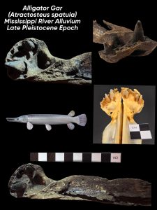 Fossil Alligator Gar
Gar are some of the most common fish fossils found in Mississippi’s geologic record next to shark and ray fossils. Gar are ray-finned fish in the family Lepisosteidae. They are known for their toothy mouths and their thick armor-like interlocking ganoid scales. Gar are exceptionally adapted to the coastal brackish and freshwaters of Mississippi and have remained virtually unchanged throughout our fossil record for nearly 100 million years. Their boney scales and teeth preserve very well and have been found in deposits along side dinosaur bones dating back to the Cretaceous period here in Mississippi.
Gar are apex predators and are considered primitive fish. They share several anatomical characteristics of their more ancient ancestors. One such feature is that they have retained a spiral-shaped valve intestine, a quality that they share with their other “living fossils” relatives such as sharks. Their adaptability comes from their ability to inhabit a number of aquatic environments because they can breathe in both air and water and some species can handle both fresh and brackish waters.
Mississippi is home to several species of gar that range in size and snout morphology like the relatively small, short-nosed gar (Lepisosteus platostomus) and the large, long-nosed gar (Lepisosteus osseus). The largest species of gar still living in Mississippi is one of our largest freshwater fish, the alligator gar (Atractosteus spatula). The alligator gar is named for its large size and alligator like teeth.
Today’s Fossil Friday is an alligator gar fossil from the late Pleistocene from the Mississippi River alluvium of our northwest Mississippi Delta region. This amazing fossil was found earlier this week by avid fossil collector Sherry Couey and identified by MDEQ’s Office of Geology scientists. Sherry’s find was described by Mississippi Museum of Natural Science scientists as a true giant. Her fossil is of the left premallixa, which is located at the tip of the snouth in the upper jaw of the fish. It is one of over a 1.5 doz tooth-bearing elements in the mouth of the gar. Bony fish in general have a lot of tooth-bearing bones; but gar have the most.
Figured in today’s Fossil Friday are also two of the largest premaxillary pairs from the Mississippi Museum of Natural Science’s osteology collections which Sherry’s find was compare with. The size of Sherry’s alligator gar fossil find is a true giant. It is comparable to the state record which weighed 234 pounds and was over 8 feet in length!
Rare Gravel Fossil Find Comes To The Franklin County Public Library’s First Annual Fossil Road Show in Meadville
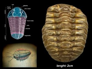 Trilobites are an extinct group of early marine arthropods that lived during the geologic periods ranging from Cambrian to the Permian, from around 521 to almost 252 million years ago. They are among some of the most successful and complex of early life on our planet. Their existence on earth spans about 270 million years encompassing over 22,000 different species now described worldwide in the fossil record. They abruptly became extinct long before the days of the dinosaurs during a major event in earth’s history along with 90% of all life on earth at the end of the Permian.
Trilobites morphology can range from fairly simple looking creatures to those that are rather quite complex and ornate. Their basic body structure is made up of three segments: a head segment called a cephalon, a mid-section called a thorax, and a tail section a pygidium. These animals molt their exoskeleton as they grow, like modern arthropods. Because of this, molted individual segments of the animal can be found along with complete specimens in the fossil record.
In Mississippi, trilobite fossils are best known from outcrops of the Devonian age Ross Limestone in Tishomingo County which can be found along the Tennessee River. They are also rare, treasured finds in south Mississippi among the ancient Paleozoic fossils in our chert gravels.
Today’s Fossil Friday is a spectacular trilobite fossil from chert gravel collected in Franklin County, Mississippi from the Pre-loess Terrace gravels. It was brought in by a local rock collector to the first annual Franklin County Fossil Roadshow which was held last weekend at the public library in Meadville. Among the many other wonderful things brought in by the public, this rare trilobite fossil was identified by one of our MDEQ’s State Survey geologist who was on hand alongside the Mississippi Museum of Natural Science for the event to assisting the public with their rock and fossil finds.
This fabulous tiny trilobite fossil is represented by an exceptionally well-preserved thorax and pygidium segments and may likely belongs to the order of relatively simple-shaped Phacopid trilobites. Though the trilobite is quite ancient, its history of its presence here in Franklin County in the geologic record is significantly more recent. This trilobite is hundreds of millions of years old yet its presence here is due to the evolution of the ancestral Mississippi River through the county during the middle part of the Pleistocene epoch, some 700,000 years ago.
The chert gravel deposits in Franklin County are derived from Paleozoic era bedrock in the mid-continent that eroded within the watershed of the ancestral Mississippi River and carried down here by the ancient courses of the river. They were left behind in river terraces by the ancient Mississippi River. This was a result of the river’s migration westward and cutting ever deeper into the coastal plain. This was a geologic response of the river to drastic sea level fluctuations from episodic glaciation of the North American continent during the ice ages of the Pleistocene.
A Whale of a Find
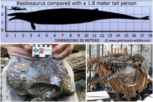 The media and public interest around the recent discovery and scientific excavation of the Columbian mammoth tusk on the Jackson Prairie in Madison County has been phenomenal. But believe it or not, it wasn’t the only impressive fossil encountered by our State Survey geologist in the field that day!
While the plaster jacket placed by our paleontological team to encase the mammoth tusk for removal was drying in the summer sun, the team spent this valuable time gathering evidence about the depositional setting of how the mammoth came to rest, was buried, and how it became preserved by careful study of the geologic outcrops exposed at the excavation site and nearby.
Along the stream channel, the team observed a nearly continuous outcrop of the unconformable contact between the gravelly sands and silts of the Pleistocene alluvium containing the tusk and the underlying clays of the Late Eocene Yazoo Formation. These outcrops record the stream’s incision into the landscape of the Jackson Prairie during the last ice age.
The rich soils of the Jackson Prairie region of central Mississippi, which once hosted a broad diversity of ice-age megafauna (including mammoths), formed atop the outcrop belt of the Yazoo Formation. The clays of the Yazoo Formation once formed at the bottom of a deep ancient sea that covered much of Mississippi nearly 40 million years ago. Our survey team recovered fossilized wood remains in the stream alluvium while also finding abundant fossil shells of marine mollusks in the Yazoo Clay beneath.
While the geological survey team studied the outcrops, Eddie Templeton spotted a large fossil bone about the size of a tree trunk protruding from the stream bed. The bone was not from the mammoth the team was there to excavate, nor was it part of any other ice-age mammal. The bone was from a significantly larger and far more ancient mammal than the mammoth. The survey team immediately recognized it as a vertebra belonging to an archaeocete whale, a type of early primitive toothed whale from the late Eocene Yazoo Clay outcropping along the stream bed. This fossil archaeocete lumbar vertebra that Eddie had found was specifically from a true giant named Basilosaurus cetoides.
Basilosaurus was the largest of a number of ancient whales that swam the warm tropical waters of the Gulf of Mexico at this time, including Cynthiacetus, Dorudon, and Zygorhiza. Basilosaurusalso shared the oceans with these other large primitive whales alongside some of the largest predators on earth at the time, including megatoothed sharks like Otodus auriculatus (precursor to the infamous megalodon).
Basilosaurus was the largest animal on earth during the Eocene epoch. Because of their size, early scientists working here in the southeast who came across their fossil remains mistakenly thought Basilosaurus was a type of dinosaur. It wasn’t until these animals were more properly studied that they were determined to be mammals. Geologic mapping of the Jackson Prairie region determined that the sediments they are found in are actually Eocene in age, therefore younger than the days of the dinosaurs.
Basilosaurus fossils have also been found in other parts of the world too, more famously in the “Valley of the Whales” in the deserts of Egypt and more recently from the mountains of Peru, but Mississippi’s fossils are arguably the best preserved anywhere. Mississippi is so famous for archaeocete whale fossils that the Mississippi State Legislature adopted the fossil whale as our official State Fossil in 1981. A composite reconstruction of Basilosaurus cetoides based on a nearly complete fossil skeleton excavated by the state survey team in Scott County, Mississippi, is on display hanging from the ceiling in the atrium at the Mississippi Museum of Natural Science.
The detail of preservation of Basilosaurus fossils in the Mississippi geologic record has prompted a number of important scientific studies, including research into the phenomenon of archaeocete “whale fall.” This refers to the fossil remains of animal and bacterial communities that developed around feeding on the carcass of the large animal as it came to rest on the deep, dark, ancient sea floor. This phenomenon has been documented by scientists studying modern whale carcasses on the deep ocean floor using submersible rovers. One such Basilosaurus fossil excavation in Madison County, where this phenomenon was documented, also garnered media attention: https://youtu.be/hpbJRy_XNVQ?si=k1W29GRpG-VMaMSe
Dugong Fossils from the Chickasawhay River
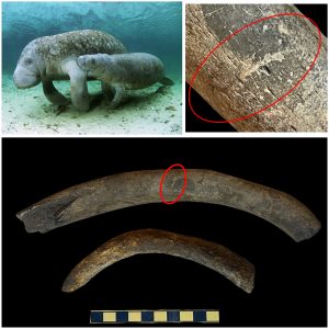 Dugongs are sirenians, a group of marine aquatic mammals that also include manatee and sea cow. Dugongs currently only inhabit the warm ocean waters of the Indo-west Pacific. They also once called the warm shallow waters of the northern Gulf of Mexico home during the Oligocene epoch, some 34 to 24 million years ago. Their remains can be found throughout limestone beds of Oligocene age in south-central Mississippi.
Dugong fossils are particularly known in Mississippi from the preservation of their ribs. These heavy, dense rib bones acted as ballast to the abdomen of the animal while it swam and fed in the shallow Gulf Coat waters on vast meadows of seagrass.
Last week a freshwater aquatic wildlife survey was conducted with Mississippi Museum of Natural Science conservation biologist and our MDEQ State Survey Geologist along the Chickasawhay River in southeast Mississippi. Natural boulder piles of limestone and sandstone found along the river channel provide habitat for the elusive and rare endangered freshwater mussel Elliptio arctata, commonly known as the “delicate spike” mussel.
While searching for the delicate spike mussel in the Chickasawhay River channel among boulders of Paynes Hammock Limestone, the crew of scientists conducting the field survey encountered a number of dugong fossil rib bones in outcrops of the Lower Oligocene, Paynes Hammock Limestone.
Closer inspection of these ancient fossils revealed numerous bite marks on the dugong ribs from large sharks. While feeding in the protection of sea grass meadows in the shallows, the docile dugong were relatively safe from predators. When they migrated out into open tropical waters, they became highly vulnerable to attacks by sharks. In these Oligocene age, Gulf of Mexico waters once swam a number of ferocious predators including the giant weasel shark, Hemipristis serra and the mega-toothed giant, Otodus auriculatus (the precursor to the infamous O. megalodon).
Mammoth of Madison County
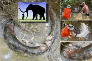 Earlier this week our MDEQ’s Mississippi State Geological Survey scientists received a message about a major fossil discovery made by Eddie Templeton, an avid artifact and fossil collector and friend of the Survey. He was exploring in rural Madison County looking for fossils when he stumbled upon what appeared to be a portion of an ice-age elephant tusk exposed in a steep embankment.
Mississippi was home to three Proboscideans during the last ice age: Mastodon, Gomphothere, and the Columbian mammoth. All three possessed ivory tusks. Mastodons are by far the most common Proboscidean finds in Mississippi as they were browsers, like modern deer, and inhabited a variety of different environments. Mammoths which were related to modern elephants are far less common finds in Mississippi as they were open grassland grazers and would have been at home in only a select few environments, particularly the prairie regions of Mississippi. Gomphothere are more closely related to mastodon than to mammoths, but very little is known about their ice-age presence here in Mississippi as they are only known from a few isolated teeth found along the Mississippi River.
Eddie knew that acting quickly on the significant find was important. From both his and our Survey Geologist’s experience that just the heat of afternoon summer sun alone could dry a specimen like this out, destroying it, and it could quickly be lost forever. The Mississippi Museum of Natural Science was also ready to respond to help by providing the material resources to our team to properly excavate and stabilize the find for removal of the important fossil.
When Eddie and our State Survey paleontological team arrived to the fossil site, they found the fossil tusk in amazing condition and was only partially exposed just above the water under a bluff in the alluvium of a small drainage. It was suspected based on the strong curvature of the massive tusk that Eddie and the team were dealing with a Columbian mammoth and not that of the more common mastodon. This would be the first of its kind for the area.
Eddie and the team spent the entire day carefully removing the clayey sand alluvial Pleistocene matrix by hand from around the tusk to expose the 7 foot long fossil it in its entirety. To our surprise, it had been deposited entirely intact. This makes it an extremely rare find for Mississippi. Most fossil tusk ivory found around the state are just fragments and most are likely to be attributable to the more common mastodon.
Once photographed in-situ, it was prepared for plaster jacketing by covering it with aluminum foil while the team began mixing plaster and cutting strips of burlap. The burlap strips were soaked in the wet plaster and placed over the foil covered fossil tusk. This was done to construct a protective jacket to encase the giant fossil for stabilization and careful removal from the outcrop.
While the plaster jacket cured and dried, the team studied the details of the depositional environment recorded within the sediments exposed at the outcrop that the mammoth’s tusk was deposited in. The base of the massive tusk was lying almost upright and at an angle in the stream alluvium with a portion of it lying directly on top of the underlying marine Eocene sediments of the Yazoo Formation, just as it came to rest before burial. Our field scientists interpreted the mammoth tusk specimen to be leaning up against the edge of an ancient sandbar of a stream while a portion of it rest on the floor of stream channel. This would have been just before it was completely covered with alluvium entombing the fossil, possibly the result of a storm resulting in a major flooding event. The animal likely had died nearby, and its remains were then carried along the stream’s channel.
Studying the nature of the sediments exposed at the outcrop also gave our team of scientists some interesting information. The channel gravels preserved in the basal part of the alluvium is dominated by the mineral quartz with a minor amount of chert clasts. The fossil is located within the watershed of the Big Black River, and Quartz gravels like that are more reminiscent of the alluvium of the Pearl River as it crosses the Jackson Prairie region. The thick alluvial plane sediments deposited above the fossil are loess-derived silt. Loess is a wind-blown glacial silt that forms thick deposits across much of the upland terrain in western Madison County.
Once the plaster jacket containing the fossil tusk dried, it was carefully lifted onto a makeshift gurney fashioned from an ATV ramp. The fossil specimen in the jacket weighed about 600 pounds. It was then slowly maneuvered up a 50 foot, nearly vertical, bluff and onto a truck where it was delivered to the Mississippi Museum of Natural Science for further curation and careful study.
Once at the laboratory, the fossil tusk was confirmed by the Mississippi Museum of Natural Science paleontologist as indeed belonging to a Mammoth. Eddie’s discovery offers a rare window into the Columbian mammoths that once roamed Madison County along the Jackson Prairie of central Mississippi. Columbian mammoths were much larger than the infamous woolly mammoth that roamed the colder, more northern regions of North America. They grew up to 15 feet at the shoulder and could weigh over 10 tons. These colossal mammals played an important role in maintaining the rich fertile prairie ecosystem, much as their modern elephant relatives do in other parts of the world today. This ice-age prairie ecosystem of what is now Madison County was also home to herds of now extinct horses and giant bison along with giant ground sloths, giant tortoises, and tapirs. It was also home to a number of ice age predators such as dire wolves, saber toothed cats, American lion, and even to the earliest human inhabitants of our region.
How do our State Survey geologists interpret the stratigraphic record in the absence of fossils?
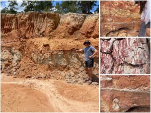 Fossils are essential for interpreting our geologic record. Our State Survey geologists study clues about Mississippi’s geologic past from careful study of outcrops. These rare bedrock exposures poking through dense vegetation and thick soil cover act as the primary windows for which we decipher our natural history. So, what if the geologic area we came to study contains no fossils?
If there are no fossils present, then there other important clues that our mapping geologist look for and use to help understand the geologic history and the ancient environments that sediments were once deposited in. Particularly while in the field at outcrops we record other things like the sedimentary structures, nature of the different sediments present, their relationship with one another, and the sequence of the stratigraphic layers that are present at the outcrop.
Last month our Stare Survey geologist visited at a road-side exposure with scientists from the University of Southern Mississippi in Stone County, Mississippi. The outcrop is situated along the drainage divide between two branches of a large dendritic stream system. At this outcrop no fossils were present to help understand the outcrop. Wonderful stratigraphy and sedimentary structures were ever present to help interpret the outcrop.
The lowermost portion of the outcrop had exposed grey-green colored, deltaic silty clay of the late Miocene Pascagoula Formation. The age of the clays of the Pascagoula Formation are known from fossils found elsewhere in the formation. Lying uncomfortably over the top of the Pascagoula clay is a sequence of coarse-grained sand with a bed of cobble-sided clay clasts. The sand exhibited sedimentary structures called crossbedding. The bed of clay clasts was found to be ripped up, eroded, and reworked from the underlying Pascagoula clay bedrock.
We can interpret the sedimentary sequence in the upper beds above the Pascagoula clay as belongs to a high-energy fluvial stream environment that once had existed atop the Pascagoula clay. This thin, localized stream terrace deposit formed from the evolution of the landscape as the dendritic stream system found nearby once eroded the Pascagoula Formation uplands. This likely was deposited during the Pleistocene epoch. During this time, south Mississippi streams and their tributaries were responding to drastic sea level changes in the Gulf of Mexico from cyclic continental glaciation. This locally eroded the landscape as the stream system evolved, leaving behind the terrace deposit.
Exploring a Pliocene Paleobotanical Site in South Mississippi
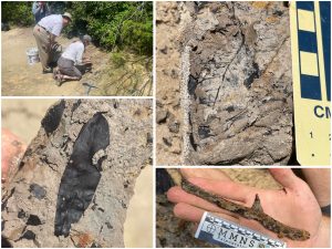 Mississippi’s geology exposed at the surface records a detailed accounting of sea level rise and fall of the Gulf of Mexico as a response to dynamic earth processes. Oceans covered the state repeatedly throughout geologic time and fell as river deltas built new land in their wake.
The site contains a wealth of 5 million year old plant fossils that were deposited in a coastal river delta prior to the onset of the Pleistocene ice ages. Fossils found here at this site are so well-preserve, much of the original plant remains are relatively intact and not mineralized. From this degree of preservation, much information can be gained about detailed structures still preserved in the plant fossils. In the field, the team collected a number of different fossil leaf, fruits and seeds, and wood specimens for careful study at the Brink Paleontological Laboratory facility at USM. Some of the genus of the fossil plants were readily recognizable and attributable to relatives that exist today in our coastal environment such as cypress, willow, and oak while other no longer exist in North America or are extinct all together. This important collaborative paleontological work will go a long way to help better understand this relatively unknown part of our state’s terrestrial geologic past.
How does fossil wood petrify?
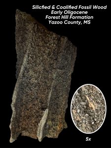 This discussion brings up geochemistry, a topic fundamental to interpreting Mississippi’s geologic record.
Much of the fossil wood throughout Mississippi’s geology deep in the subsurface is considered carbonized wood or lignite. It is wood that is relatively perfectly preserved once buried and has been permanently sealed off from oxygen.
Over time the wood turns to this low-grade coal and becomes lignitized. The geochemistry of these sediments is called a reducing environment. Iron and sulfur minerals such as pyrite and Marcasite (FeS2) also form in association with the preserved organic materials over time, even replacing some of the fossil wood and in its microscopic pore spaces.
We typically do not find deeply-buried petrified wood in Mississippi, only the lignitized/coalified forms of fossil wood, regardless the antiquity of it. Silicified wood though, is readily found at the natural surface throughout Mississippi while lignite is quite rare. This is because most silica-replacement (or petrification of the wood) likely occurs only near the surface, up in the weathering zone of a geologic formation.
Silica dissolves almost insignificantly in near neutral ground water conditions. Therefore, how does enough silica go into solution to petrify wood and replace lignitized wood with stone?
The answer most likely lies in the weathering of the sulfide minerals associated with the coalified wood. These minerals readily chemically weather, creating a very hyper-acidic environment localized in and around the fossil wood. Silica can now freely dissolve in a high enough concentration from the surrounding geology. It then is precipitated in the form of chalcedony and quartz. Chalcedony can replace the individual cell pore spaces and even the cell walls of the fossil wood in a process called per-mineralization. Quartz can grow as a cluster of fine crystals, called a druse on the outside and in larger cavities in the fossil wood. When it grows inside the fossil wood, it typically destroys many of the delicate structures of the wood. As the petrified wood becomes exposed at the surface, the remaining delicate fossil lignin quickly weathers away leaving only the parts replaced by the more stable silica minerals behind.
Today’s Fossil Friday brings us an example of fossil wood that helps to demonstrate the process we described above. This specimen is from the lower Oligocene, Forest Hill Formation of Yazoo County, Mississippi and was recently brought to MDEQ’s State Survey Geologists by William Pettis. William’s find demonstrates the petrification process of fossil wood very well. The innermost portion is per-mineralized with the chalcedony, preserving the detailed structures of the wood. The outside is coated with a quartz crystal druse and some lignite still remains intact, as depicted in the close up of the fossil wood.
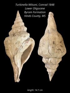 Turbinella wilsoni from the Byram Formation
The last time sea levels rose and covered a good portion of Mississippi was during the early part of the Oligocene epoch, some 30 million years ago. This left its mark in our state’s geology as a narrow band of rugged hills underlain by the fossiliferous limestone formations of the Vicksburg Group that can be tracked from Vicksburg, to Brandon, and then southeast through Waynesboro.
The limestones of the Vicksburg group were named for the exposures that can be found along the Mississippi River at Vicksburg. The geological story recoded in these beds of rock are a complete cycle of a sea level rise and fall, important details of the environments that they represented, and ecologies from the many scientifically significant fossils they contain.
Many researchers come to Mississippi to study the fossil rich deposits of the Vicksburg group for a number of important reasons, including diversity of fossils of animals preserved that lived here in the northern Gulf of Mexico at that time. Most of the preservation of the invertebrates, mainly the mollusk (which includes snails and clams) are the original shell material preserved in the rock.
The fossil shells of the Vicksburg group hold details of the paleoclimate from millions of years ago that can be ascertained from studies of the chemical signatures left in the shells, much the way we can study ice cores from just thousands of years ago during the Pleistocene epoch. The Oligocene was an important inflection point in our planet’s climate history, transitioning from a greenhouse that persisted since the days of the dinosaurs to an ice house culminating with the ice ages of the Pleistocene.
Today’s Fossil Friday features a very large gastropod fossil called Turbinella wilsoni from the Byram Formation of the lower Oligocene Vicksburg group. The Byram Formation is named after outcrops along the Pearl River near Byram, Mississippi. This specimen was collected by MDEQ, Mississippi Office of Geology scientists from an outcrop near Edwards along the Big Black River in western Hinds County. This large snail lived in the warm, shallow, near-shore waters of the Gulf of Mexico just before sea levels began to fall again across the state to near where they are today.
Spectacled Bear Fossil Found in Mississippi 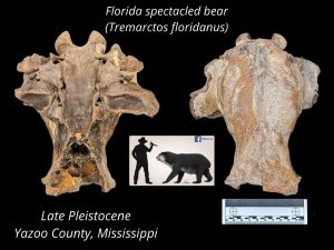
Today it is a rare and wonderful sight to see a black bear in Mississippi. Did you know that not all that long ago our State was once home to at least three (and possibly more) different bear species?
During the last ice age, Mississippi was also home to two other bears. Both of these other bears are classified as short-faced bears. One, the great short-faced bear (Arctodus simus) was a true giant and considered the largest predator on the ice-age North American landscape. The other is the much smaller Florida spectacled bear (Tremarctos floridanus) occasionally called the Florida cave bear.
The Florida spectacled bear was approximately the size of a modern black bear. If you were to have encountered it on the Pleistocene landscape, you quickly would recognize that it is quite different than a black bear. Especially noticeable would be its strikingly shorter muzzle, and possibly a color difference. What we know about this extinct spectacled bear can largely be deduced from studying its last remaining relative, Tremarctos ornatus, also known as the Andean bear or the mountain bear which still lives in South America. The South American spectacled bear is last remaining short-faced bear. It is omnivorous like most bears, but their diet is in large herbivorous.
Vertebrate fossils of terrestrial mammals are extremely rare in the geologic record. Most of what we know about the vertebrate fossil record in Mississippi, particularly from the ice ages of the Pleistocene are from finds the public makes that are brought to our scientists attention. Today’s Fossil Friday comes to us from William Pettis who found this amazingly well-preserved fossil skull of a Florida spectacled bear in loess bluffs region of Yazoo County, Mississippi. It was brought to our State Survey geologist’s attention here at MDEQ earlier this spring. It was properly identified by scientists and donated into the paleontological collections at the Mississippi Museum of Natural Science for future studies.
It is highly likely that the first people in Mississippi did encounter the spectacled bear along with a host of other extinct megafauna towards the end of the Pleistocene epoch. Along with the short-faced bears, Mississippi ice-age landscape was also home to mammoths, mastodon, saber-toothed cats, American lion, giant bison, giant ground sloths, tapir, along with many other animals that went extinct at the close of the Pleistocene epoch.
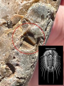 Ancient Trilobite Fossil Found In Mississippi Gravel
This extremely rare Paleozoic era fossil arthropod, called a trilobite, was photographed by MDEQ, Office of Geology staff in a stream in the loess bluffs region of western Mississippi.It was found while conducting fieldwork last month in Yazoo County, Mississippi by Surface Geology division scientists.
Trilobites existed for nearly 300 million years and long before the days of the dinosaurs. Trilobites first appeared in the fossil record in the Cambrian period (over ~500my ago) and then suddenly disappeared during the great mass extinction event of the Permian period (~250my ago).
A trilobite has three main segments: a head (cephalon), a middle section (thorax), and a tail (pygidium) which is the part found in this example. Like other arthropods, they shed their exoskeleton as they grow. Many of the fossils of trilobites found areactually theirpreserved ancient exoskeleton sheds.
Most of the types of rare trilobite fossils found in our Mississippi’s chert gravels are not from ones that once lived here.So then, how did they get here?They were once part of an ecosystem in the bottom of an ancient tropical sea which is now part of the mid-continent of North America.The sea dried up and the land rose, exposing the limestone bedrock that contains these fossils at the surface.
Later during the mid-Pleistocene the ancient ancestral Mississippi river drained its way across Mississippi to the Gulf of Mexico, leaving behind the gravels that can be found in the hills and loess bluff streams across much of Yazoo County. This spectacularly preserved trilobite fossil is one of many ancient treasures that can be found in our Mississippi chert gravels.
FOSSIL WOOD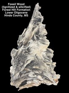
Fossil wood is the most common type of fossil found in Mississippi. It can be found in just about every geologic formation exposed at the surface in the state, dating from the Cretaceous to the Pleistocene in age. That is encompasses the time from the days of the dinosaurs (almost 100 million years ago) to the last ice age (just 10’s of thousands of years ago) and every time period in between. It also can be found from every ancient depositional environments represented in our geology here in Mississippi including fluvial, deltaic, estuarine, and even marine settings.
Studying the details preserved in fossil wood can be an important tool for our geologists. It can tell us quite a bit about ancient depositional environments, especially in places that there are no other fossils present to give us clues about the ancient past. Fossil tree trunks that exhibit buttressing demonstrate that they grew in wet and poorly drained environments. In marine environments wood is quickly colonized by pholad boring clams of the family Teredinidae also known as “shipworms”. Where we find these, we know that they were deposited as driftwood in a saltwater environment. In terrestrial settings, holes in fossil wood can be caused by insects or other animals such as birds.
Though fossil wood is so common, very little is known paleontologically speaking about our fossil wood resources. Few fossil plant scientists, called paleobotanists study it here. It can be very difficult to identify down to certain genus or species level compared to other abundant plant fossils available such as leaves and ancient microscopic spores and pollen.
Fossil wood in Mississippi comes in two main types of fossil preservation. One is lignitized, a form of low-grade coal in which the original lignin of the wood is preserved. Lignitized wood is very unstable after it is exposed by natural erosion and doesn’t last long in the elements before disintegrating. The other type of fossilization of wood is silicification. This occurs when lignitized wood is further replaced with more stable silica minerals (such as quartz and chalcedony) from exposure to silica-rich groundwater.
Silicified wood is also commonly referred to as “petrified wood”. It is such a popular find amongst our state’s rock collecting enthusiasts that it was adopted as our official state rock or “state stone” by the Mississippi State Legislature in 1976. Much of the silicified wood in Mississippi is per-mineralized, meaning the microscopic details of such things as the cell walls and other structures in the fossil wood remain preserved intact.
THE STARKVILLE CLOVIS
 Our relationship with our environment and its resources was just as important in the ancient past as it is to us today. Geologic mapping is essential to understanding our landscapes, their age and evolution, their detailed underpinnings, and the distribution of our valuable natural resources.
Geology is essentially the basis for our environment and is also an integral part of archaeology, the study of our human history. Geology is especially important for characterizing geomorphology, depositional environments, and the natural geochemistries that are conducive to the presence and preservation of our state’s archaeological resources.
How long people have been in Mississippi and North America is an important question for us as scientists to try and answer. Humans entered the paleontological record here in Mississippi at some point during the last ice age. This is a time known as the late Pleistocene epoch to geologists and as the Paleoindian period to North American archaeologists. We do know that when Native Americans first arrived here in what we know as Mississippi, they encountered an environment that would seem quite strange to us today. The plants of the forests, bottomlands, and even prairies would be more familiar in much more modern northern climates than to those of the deep south of today.
The early Paleoindian people also shared the Pleistocene landscape with an even stranger variety of giant animals, called megafauna, that are now long extinct. The prairies of northeast Mississippi in particular, were once home to an abundance of ice-age wild game that included mammoths, mastodon, giant bison, bear, horses, giant ground sloth, and tapir. We know this because their fossil remains are finds commonly preserved in stream alluvium along the prairie region. There were also a number of predators here such as American lion, saber-toothed cats, and even giant bears.
Stone tools that the earliest indigenous inhabitants left behind during the Pleistocene, called lithics in archaeology, are the only evidence that we have of their presence on the ice-age landscape. Geoarcheological analysis of Paleoindian period lithic artifacts and the settings they are found in is about the only window we have to study and learn about these earliest inhabitants and the details about their lives and their relationship with the ancient environment.
The chronology of the ice-age first people is largely understood by scientists through their stone tool styles or traditions. The Paleoindian period people were thought to be highly skilled nomadic hunters specializing on the now extinct megafauna animals of the late Pleistocene. This is evidenced by the exquisitely made stone tools and the paucity of longer-term occupation sites that they left behind.
The discoveries of most of the known early Paleoindian artifacts in North America are quite happen-chance. They are typically stumbled upon by landowners, artifact hunters, and rock collecting enthusiast. Only, very rarely are they discovered by professional scientific researchers conducting work in the field. This makes the public, those who have discovered and reported these rare artifact finds here in Mississippi, our primary resource of information we have to study this earliest human time period in our cultural prehistory.
Earlier this year, an amazing discovery of an extremely rare Paleoindian period artifact was found by Ryan Mann while artifact hunting with his sister. Ryan quickly brought it to the attention of our field research team here at the State Geological Survey, at MDEQ where it was closely studied. Ryan’s discovery was of an artifact called a Clovis point. The exquisitely made, lancelot-shaped artifact measured 77mm long, 30mm wide, and 14 mm in thickness. Dating back to more than 13,500 years, Clovis points are the earliest recognized human artifacts known to be found in Mississippi and the earliest wide-spread tool tradition in North America. His important discovery was made just outside of Starkville, specifically along the western margin of the prairie region.
Ryan’s rare discovery is instrumental to the understanding of our state’s deeper ancient history for a number of reasons. It is the earliest human artifact ever to be recorded in Oktibbeha County, Mississippi. This fills in an important gap in the state’s known distribution of Clovis culture artifacts. It is also one of the finest examples of the expert craftsmanship of the Clovis tradition ever to be found in Mississippi. A difficult to achieve channel flake called a “flute” occurs on both sides of the base of the stone artifact where it was once hafted.
Ryan’s rare ancient artifact find reveals some very important clues about the ice-age people who once lived in northeast Mississippi, particularly about their utilization of the resources in their natural environment. The prairie and bordering flatwoods region of Oktibbeha County have no natural stone resources adequate for flint knapping native to the local geology of the area. Therefore, essential materials for stone tool manufacturing had to have been carried or imported in from geologic resource areas found much further away.
The Starkville Clovis is manufactured from a textbook example of a type of Fort Payne Chert that can only be found along the Tennessee River in what is now Pickwick Lake. The use of Fort Payne Chert by the early Paleoindian people also hints at the strictness and attention to detail for the Clovis tradition of tool manufacturing in the area. The poorer quality gravels of the Tuscaloosa Formation were an adequate lithic resource that could be found just a little closer by than the outcrops of Fort Payne Chert but seemed to have been purposefully overlooked by these earliest ice-age inhabitants crossing the prairie region until much later on. Conversely, much further to south in Mississippi, more local chert gravel resources were utilized very early on by the Clovis people. This is due to the lack of higher-quality resources available to the area and the much greater distance to other higher-quality bedrock resources.
MDEQ’s Surface Geology research staff have recently conducted field research and published detailed geologic maps of the Starkville area. Knowledge of the geoarchaeological setting that the Starkville Clovis was found in is also significant to our scientists in studying this discovery.
Ryan’s Clovis point was found in an area where springs are known to occur bordering the edge of the prairie region. These springs emanate from the channel sands of the Paleocene age Clayton Formation where they occur incised unconformably into the chalk of late Cretaceous age Prairie Bluff Formation. This particular geological setting provided these Pleistocene inhabitants with a consistent freshwater resource along the western border of the prairie around the Starkville area. It would have also attracted an abundance of ice-age wildlife and a rich forage of other natural resources.
A special thanks to Ryan Mann for sharing his important artifact find with us. As other rare early artifact finds come to light in Mississippi and are brought to the attention of our state scientists to be documented, the greater the potential for a better understanding of these earliest Mississippians and their cultural patterns across the ancient landscape. Also, the potential for more discoveries becomes evident and a more complete, and likely a more complex picture will emerge about the life ways of Mississippi’s earliest inhabitants during the last ice age.
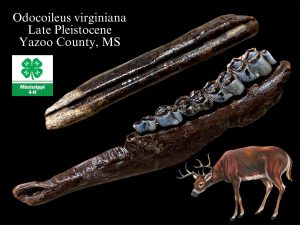 Fossil White-Tailed Deer
Most people don’t think of white-tailed deer (Odocoileus virginiana) as a living fossil, but the highly-adaptive whitetail deer is likely the oldest large mammal species still living in North America today. White-tailed deer are derived from a common ancestor of the modern Eurasian deer that migrated across Beringia sometime during the later part of the Miocene epoch and quickly spread across the North American continent. White-tailed deer replaced an ecological niche once filled by the slender three-toed horses. Whitetail deer fossils found from Florida date back as far as 3.5 million years ago. By contrast, modern humans have only been on earth for around 200,000 years and people have only been in North America for roughly 20,000 years.
With the onset of cyclic glaciation during the Pleistocene epoch in North America, vast areas changed from deciduous forest to tundra while large parts of the continent were completely covered in ice sheets up to a mile thick. With water locked up in ice, vast expanses of the coastal plain were exposed with lower sea-levels. These drastic climatic cycles repeatedly altered the range of white-tailed deer during the ice-ages, while the forests of the Mississippi’s Gulf Coastal Plain would have remained a relatively stable habitat for them.
White tailed-deer are common fossils found in Pleistocene age deposits in Mississippi, but that doesn’t mean that they were nearly as common as living ones are today. White-tailed deer were also in direct competition for resources with peccaries, llamas, and tapirs in the forested environments of the southeast, while bison and horse were more successful in the prairie grasslands. Other deer and moose, such as stag-moose and mule deer also called Mississippi home during the last ice age. A diversity of predators on Mississippi’s Pleistocene landscape existed (in addition to humans) such as American lion, saber-toothed cats, dire wolves, panthers, and great short-faced bears also fed on white-tailed deer.
Today’s Fossil Friday brings us to a couple of ice age white-tailed deer fossil finds. This discovery of a partial fossil cannon bone and lower jaw also shows signs of ancient gnaw marks from rodents that once chewed on the bone for calcium. These finds were made last week by MSU Extension Service agents in the field with MDEQ’s Survey Geologist in Yazoo County, Mississippi. The rock and fossil collecting trip was designed MDEQ staff as an agent training field exercise to educate 4-H coordinators in the newly-adopted 4-H Geo-Arc environmental science program in Mississippi. The rock and fossil collections made during this field trip and the valuable knowledge and experience gained by the MSU Extension Service agents will go back with the agents. It will be used to help youth learn about our state’s rich natural & cultural history and help to develop the budding Geo-Arc curriculum within their own county 4-H programs in which they educate and serve.
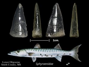 Ancient Barracuda of Mississippi
Barracuda are a large salt-water fish of the genus Sphyraena. They are one of the most notoriously ferocious predators in the tropical and subtropical waters of our oceans today. Known for their toothy mouth, aggressive nature, and lightning speed barracuda are a popular sport fish and exciting sight for people snorkeling in shallow warm ocean waters. They are commonly caught here in Mississippi, but their meat can contain toxins dangerous to people in areas where the barracuda primarily feed on fish in coral reef environments.
Barracuda teeth are also common finds in some parts of Mississippi’s ancient fossil record. It is thought that barracuda originated as far back in time as the Paleocene epoch, some 60 million years ago. They evolved as part of a biodiversity explosion that was filling the vacant niches in the ocean after the extinction event that killed off dinosaurs along with much of marine life.
Barracuda tooth fossils can be identified by their distinctly triangular shape. They can be differentiated from fossil shark teeth by their lack of a root to the tooth, slightly bi-convex shape, and narrow profile. They are most abundantly found in Mississippi in fossiliferous limestones of Oligocene age. These can be found in outcrops across the south-central part of the state, bordering the Jackson Prairie region.
Today’s fossil Friday brings us to a large specimen of a fossil barracuda tooth found in Smith County, Mississippi by one of our Survey Geologist conducting routine paleontological fieldwork. It was collected from the fossiliferous sandy marl of Mint Springs Formation member of the Vicksburg Group. The limestones of the Vicksburg group contain a diversity of tropical marine animal fossil remains including mollusk shells and echinoderms, in addition to numerous teeth of fish and sharks. The limestones of the Vicksburg group represent the last time the oceans covered a good portion of Mississippi, some 30 million years ago, before sea levels fell to where they are today. The Mint Springs member represents the near-shore environment as part of the initial marine transgressive stage. The barracuda tooth is just a part of the larger fossil evidence of the bounty of sea life that once inhabited the shallow tropical waters of the Vicksburg sea.
Evactinopora Fossil from Harrison County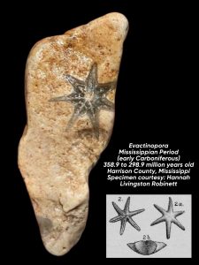
Fossils can be found just about anywhere in Mississippi. They are the clues that help our scientists decode and reconstruct the past worlds recorded in our state’s remarkable geology. The fossils come in many forms such as animal bones, shells, and teeth or their traces such burrows and footprints. Plant fossils such petrified wood, leaves, and even fossil pollen are also common throughout Mississippi’s geology.
In most instances, fossils can also help tell the age of the deposits in which they are found. But in some cases, fossils can become reworked into younger deposits. That is the case for our State’s popularly collected fossils in our chert gravels.
Such a diversity of well-preserved remains of marine invertebrates such as corals, brachiopods, snails, and even cephalopods can be found throughout our gravel deposits. Their abundance in Mississippi makes them ideal for casual fossil hunting in many of our stream’s gravel, as well as gravel driveways, parking lots and playgrounds.
These gravel fossils are incredibly ancient, especially compared to the natural deposits here. Most of our geologic deposits containing these fossiliferous gravels are only a few million to a few thousand years old, dating from the late Oligocene to the late Pleistocene. The gravel fossils themselves though are actually hundreds of millions of years old, dating back to Paleozoic era, long before the days of the dinosaurs.
Our Paleozoic gravel fossils weathered from ancient marine limestone bedrock deposits up in the mid-continent. They were then left behind here by streams and rivers that drained their way across Mississippi towards the Gulf of Mexico. Studying the different fossils in our various gravel deposits can help us reconstruct ancient watersheds of streams, with headwaters in bedrock regions hundreds of miles away.
Today’s Fossil Friday takes us all the way down to the Mississippi Gulf Coast in Harrison Conty where Hannah Livingston Robinett found this unusual star-shaped fossil in gravel. This fossil was posted on South Mississippi Fossils and Artifacts Facebook group and identified by our State Survey Geologist in our MDEQ’s Office of Geology. It is an excellent example of a type of bryozoan called an Evactinopora.
Bryozoans are filter-feeding animals that lived in colonies, and some types that lived on the sea floor secreted a hard mineral skeleton to live in, similar to that of corals. Bryozoan fossils are fairly common in our gravels, particularly the lace-like fronds of Fenestrallina and Archimedes or the twig-like branches of Trepestomes. Though, the star-shaped Evactinopora are indeed quite rare and special finds in our gravels here in Mississippi.
Evactinopora lived during the Mississippian Period (Early Carboniferous) and represent one of the most unusual and beautiful of all the bryozoan forms and date between 358.9 and 298.9 million years old. The limestones this specimen came from were deposited in a warm shallow sea that is now long gone, only leaving behind limestones containing their fossils remains.
Evactinopora are most common in outcrops of the Early Mississippian (Kinderhook) Fern Glen Formation which can be found in southeastern Missouri. Hannah’s amazing fossil find helps our scientists understand the rich natural history of our state and a window into the long journey it was on to make its way to our Mississippi Gulf Coast.
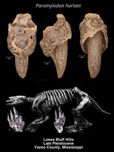 Giant Ground Sloth in Ice-Age Mississippi
We continue to learn about Mississippi during the Pleistocene, the geological epoch that lasted from c. 2.58 million to 11,700 years ago from the ancient clues left behind in the geologic record of the ancient past. Mississippi was a vastly different environment at the time of the great ice-ages of the Pleistocene. Repeated glacial episodes gripped the more northern parts of our continent that had direct effects on our state, its climate, and to sea-levels along our coast.
Our Survey geologists continue to paint a picture of what this ice-age world was like here through geologic mapping and the paleontology of the plants and animal remains left behind in our rich fossil record.
The clearest picture of the fossil record of Mississippi for the Pleistocene is largely limited to the last glacial episode which saw its height around 20,000 years ago and ended roughly 11,000 years ago. Because of the work of our scientists, both here at the Survey and at the Mississippi Museum of Natural Science, as well as numerous fossil donations from citizen scientists in the public we have a fairly accurate picture of the biodiversity of mammals that were here, including Mississippi’s first human inhabitants.
The landscape, geomorphologically-speaking, was not much different than today. Many of the landforms and even the rivers and streams would be somewhat recognizable with the exception of the coastline which extended miles out into what is now the Gulf of Mexico. The plants and animals though, which made up the ice-age ecosystem, would have seemed other-worldly. Mississippi was home then to giant mammals, called megafauna included mammoths, mastodon, tapir, giant bison, saber toothed cats, lions, dire wolves, giant bison, stag moose, great short-faced bear, spectacle bear, and the Paleoindian inhabitants that exploited this bounty of big game animals.
Giant ground sloths were also a common sight throughout Mississippi’s ice-age landscapes. These massive herbivorous creatures grew larger than modern bears and grazed and foraged on the abundance of lush cooler weather vegetation that grew in the prairies, hills, floodplain, and coastal meadows throughout the state.
Several different kinds of now extinct, giant ground sloths called Mississippi home during the last ice-age. The largest of these was Eremotherium, which grew to be the size of a modern elephant. Megalonyx jeffersonii, was a heavy built ground sloth with large claws that grew to the size of a modern cow.
Today’s Fossil Friday focuses on Paramylodon harlani, one of the more unusual giant ground sloth that would have been a common sight on Mississippi’s ice age landscape. Featured today is an exceptionally well-preserved fossil claw and sheath of one found earlier this week in the Loess Bluffs region of Yazoo County, Mississippi by accomplished fossil hunter, William Pettis. He brought it to the attention of MDEQ’s survey geologist and Mississippi Museum of Natural Science paleontologists where it was properly identified and documented.
Paramylodon harlani (also commonly known as Harlan’s ground sloth), was bear-sized ground sloth that grew to about 9.8 feet in length and weighed up to as much as 1.5 metric tons. This robustly built sloth likely walked on primarily on all four legs and had a strong neck and tail. One of the unusual adaptations of this ground sloth was a set of bony plates that were embedded in its skin called dermal ossicles. This armor added significant protection against attack from the numerous large predators that lived alongside it on the ice-age landscape of the time including the earliest Paleoindian human inhabitants.
Harlan’s ground sloth were thought to burrow and create large tunnels into the ground where the geology permitted. Though no direct evidence has been yet made for this type of activity by this giant ground sloth in Mississippi, the thick loess deposits exposed in the bluffs along the stream valley where William Pettis found this fossil would be considered quite ideal for such. The more we learn about these extinct animals and map the geology of the environments they once lived here in Mississippi may help to shed better light on their lifestyles and habits.
In the Limestone of the Clayton Formation
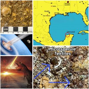 About 66 million years ago, Mississippi had a front row seat to one of the most devastating and consequential events in the history of our planet. A meteorite more than 10 kilometers wide struck the Gulf of Mexico near the modern-day Chicxulub in the Yucatan, ending the rein of the dinosaurs and extinguishing more than 70 percent of all life on our planet.
The time is known by geologists as the Cretaceous period which saw the last days of the dinosaur and after this extinction event in the fossil record marks the beginning of the Paleogene. During the Cretaceous, Mississippi was mostly covered by a warm tropical shallow sea teaming with a broad diversity of life. Their remains, which also include those of dinosaurs that lived near the shoreline, are exceptionally well preserved in the fossil record in the rock outcrops of northeast Mississippi.
This fateful day in our earth’s history sent a massive shockwave round the world like a nuclear explosion, leveling everything in its path. It was followed by a massive tsunami around the world’s oceans, with Mississippi taking a direct hit. Then molten glass called tektites fell down on the earth like rain from the atmosphere, leaving a wrath of destruction like the earth had never seen before or even ever since.
This extraordinary event in earth’s history is well represented in Mississippi at the contact between the Late Cretaceous Prairie Bluff/Owl Creek Formation and the overlying Paleocene age Clayton Formation. This geologic boundary is being mapped and studied by our Mississippi Geologic Survey scientists at MDEQ from outcrops near the Alabama line in Kemper County and north through, Oktibbeha, Clay, Chickasaw, Pontotoc, Union, and Tippah counties to the Tennessee state line.
Earlier this spring, our geologists were notified by our colleagues in the field at The University of Mississippi’s Geology and Geologic Engineering department about outcrops they were documenting of this geological contact of worldwide significance between the two formations that were being exposed as a result of highway construction work in Union County, just south of New Albany. Our Surface Geology team was already working with the Mississippi Museum of Natual Science paleontology program in the area and was advised by Dr. Julie Retrum at Ole’ Miss about further construction work planned that possibility might lead to new exposures for us to come study.
Last month after working with the Geology department at USM on a dinosaur fossil site in nearby Prentiss County. Our Geological Survey team visited and studied the freshly exposed road cut near New Albany that was discussed with us previously and indeed our timing was perfect as we found an outcrop of the Clayton Formation as hoped.
In the limestone of the Clayton Formation our scientists discovered a bed of fossil seashells that had been ripped from the sea floor of the underlying Owl Creek Formation. This reworked Cretaceous shell bed into the younger deposits has been hypothesized as possible evidence of the tsunami, but what we also found was more certainly evidence of the catastrophic meteorite impact. Throughout the limestone were tiny round spherules, the remains of the molten glass tektites that rained down on the planet after the extraterrestrial impact that ended the Mesozoic era and the days of the dinosaurs. The rock samples and measurements taken during the study will be used to for further our geologic mapping efforts in northeast Mississippi and our studies of this important event in earth’s history.
Ancient Gulf Sea Urchin 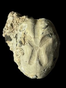
This delicate fossil echinoid is called Brissopsis. It was collected last month by MDEQ’s Office of Geology staff while leading a paleontological field trip to a limestone outcrop in Smith County. The scientific educational exercise was conducted for Mississippi State University’s geology students and earth science students at Jones County Community College. During the field trip, students were introduced to the environmental science of geology and Mississippi’s rich natural history through an exercise in paleontology and stratigraphy.
Brissopsis is small genus of sea urchin (about the size of a pecan) belonging to the order Spatangoida that once inhabited the warm shallow waters of the Gulf of Mexico during the earlier Oligocene (Rupelian), some 30 million years ago. This specimen was found in the Mint Springs member of the Vicksburg Group, which was deposited in a near shore environment. Brissopsis was a bottom feeder and was covered in a fine layer of short, bristle-like spines that it used for both protection and locomotion as the animal burrowed into the soft sediments of the sea floor.
The limestones deposited in this area during that time are known as the Vicksburg Group, because they were first described by scientists from prominent outcrops along the Mississippi River in the vicinity of Vicksburg, that can still be seen along Washington Street today. These deposits and the ocean here at that time are referred to as forming in the “Vicksburg Sea”. The outcrop belt of the fossiliferous limestones of the Vicksburg group form a narrow belt of aggressive terrain through central Mississippi just south of the Jackson Prairie. This limestone belt stretching from the city of Vicksburg through Byram, Brandon, and southeast through Waynesboro. Here many other fossils can also be found such as shark teeth, sand dollars and seashells.
Ice-Age Mississippi
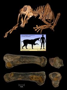
Mississippi was a greatly different world during the last ice age. This strange environment encompassed forests, swamps, and grasslands full of giant mammals called megafauna by paleontologists. Mastodon, mammoth, giant ground sloths, tapir, stag moose, horses, and giant bison were common wildlife once found throughout the state during late Pleistocene epoch…and so were the first human inhabitants here that hunted this natural bounty.
Humans in Mississippi at this time were also living amongst and competing with some of the most dangerous ice-age predators anywhere on the planet. Fossils of these apex predators are very rarely found compared to the bounty of herbivores they preyed upon. Typically only isolated bones and teeth (or projectile points of our human ancestors) remain of their existence.
Great short-faced bear, American lion, and saber-toothed cat fossils have all been found here in Mississippi, as well as projectile points of the Clovis cultural tradition.
Today’s Fossil Friday brings us to an extraordinarily rare find made by Eddie Templeton in Yazoo County, Mississippi last month. It is a fossil toe bone found in late Pleistocene stream alluvium in the loess bluffs region. It was brought to the attention and identified by Mississippi Museum of Natural Science paleontology staff and then photographed and measured by MDEQ’s Geological Survey scientists. The toe bone belongs to none other than the iconic saber-toothed cat, Smilodon fatalis. The reporting of this extraordinarily rare find helps our state’s earth scientists to better understand this important chapter in our state’s natural history and to document our rich geologic heritage. As the climate began to warm at the close of the Pleistocene epoch, the ecology began to change with it, and the ice-age megafauna disappeared into extinction from the Mississippi landscape some 10,000 years ago.
Coprolite Collected from Lauderdale County
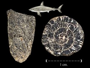 Ichnofossils are an important part of interpreting the geologic record studied by a particular specialty in paleontology called ichnology. Ichthyologists study these fossils (commonly known as “trace fossils”) which include things like animal footprints, burrows, feeding traces, and even fossilized animal dung called “coprolites”. Icnofossils help earth scientists to better understand the stratigraphic record recorded in ancient depositional environments by reconstructing habitats and even entire ecosystems of animals that once lived during the time of deposition.
Some animals leave bones, shells, and teeth behind as fossils for geologists to interpret, but some geochemistries are not conducive for the preservation of these clues. Here ichnofossils can become the only paleontological record we have for study. Also, some animals do not contain “hard parts” that are conducive to fossilize, therefore ichnofossils are all we know of their existence in the geologic past.
Each type of ichnofossil gives some level of detail of how animals lived, fed, and moved but coprolites in particular offer some of the most interesting of details about an animal’s life to study. The study of coprolite morphology and other characteristics is important to attributing these fossils to a particular animal. In cases of some invertebrates and cartilaginous vertebrates, their coprolites are the only thing we have preserved in the fossil record to study. Studying coprolite contents can also give us incredibly accurate insight into the diet and health of extinct animals that studying their bones and teeth can only be suggested from.
This week’s Fossil Friday brings us a small coprolite that is Paleocene in age collected from the Bell’s Landing marl in Lauderdale County Mississippi and is about 55 million years old. This fossil, collected during routine outcrop investigations by our MDEQ Mississippi Geological Survey, is from an Elasmobranch that was discovered in eastern Lauderdale County, Mississippi. Elasmobranch (Elasmobranchii) is a subclass of cartilaginous fish that includes modern sharks, rays, skates, and sawfish. These animals are typically known only for their fossil teeth. Their coprolites are diagnostic fossils known from their unique shapes. This particular one is spiral shape is due to the spiral intestinal valve of a shark.
The Paleocene epoch from which this coprolite is from, is a very important time in earth’s history. It encompasses the first 10 million years following the great mass extinction event at the end of the Cretaceous period that ended the rein of the dinosaurs and wiped out 75 percent of life on this planet. The abundance of small shark and ray fossil teeth and coprolites preserved in these deposits in east Mississippi record how life in the oceans began to recover and diversify after the devastating extinction event that ended the Mesozoic era. This specimen has been accessioned into the Mississippi Museum of Natural Science’s paleontological collections for curation and further study.
Ancient Marine World of Jackson
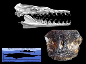
Some 38 million years ago, our capital city was covered by a warm tropical sea. The evidence of this comes from the numerous perfectly preserved marine fossils found in and around the Jackson, Mississippi area. Sharks’ teeth, giant oysters, and seashells from the late Eocene epoch have been found in outcrops of the Moody’s Branch and Yazoo Formations throughout the metro area. The clay and marls of these two geologic formations lock in time many fossils of the ancient sea life of organisms that once lived here. This evidence can be seen at outcrops along the nature trail behind the Mississippi Museum of Natural Science in the steep bluff overlooking the Pearl River and exhibited in displays along the fossil wall inside the museum. These include the fossil remains of some of the largest animals on earth, such as complete fossil skeletons of giant basilosaurs and fossil teeth of some of the largest sharks to have ever lived. This makes the Moodys Branch and Yazoo Formation a treasure trove for fossils for our state scientists to study and learn from through this rare window into the deep past of our state’s natural history.
Scientific discoveries of all kinds are made by the important work of many of our state scientists and researchers in the field throughout the state. This week’s Fossil Friday highlights a fascinating discovery of a fossil vertebrae of an archaeocete whale called Zygorhiza kochii. The find was made by our State Ichthyologist and Curator of Fishes, Robbie Ellewanger at MDWFP’s Mississippi Museum of Natural Science while conducting a freshwater mussel survey along the Pearl River near downtown Jackson. The rare fossil was brought to the attention and identified my MDEQ’s Office of Geology staff.
Zyghoriza kochii (the fossil whale) is the Official State Fossil for the State of Mississippi. It is the smallest and most agile of our Archaeocete whales found here, but this ferocious predator was at the very top of the food chain in the seas at this time in our geologic past. These incredible creatures died out at the end of the Eocene epoch and their descendants diversified to become both the modern baleen whales like the blue whale and the toothed whales such as dolphins and killer whales.
We at MDEQ appreciate the work of our friends and fellow scientists at the MDWFP’s Mississippi Museum of Natural Science in sharing their finds with us that helps us to better understand our environment, both from our deep geologic past and here in the present.
Mammoths in Mississippi
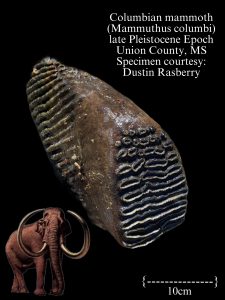 Three different types of elephants are known to have roamed Mississippi towards the end of the Pleistocene epoch and there is little doubt that Mississippi’s first human inhabitants were also here to witness them before these giants became extinct.
The most common of these fossil elephant remains that are found here are of the American mastodon (Mammut americanum). More primitive than the modern elephants, these giants had lived on the Mississippi landscape long before the onset of the Pleistocene ice ages. Mastodon were browsers, much like deer are today. Like modern deer, they were well-adapted to a lifestyle in many environments, by eating the variety of vegetation available in different habitats throughout Mississippi.
Gomphotheres are the most primitive and the rarest of fossil elephants found in Mississippi. Fossils of gomphothere have also been found from the late Miocene sediments of southwest Mississippi. Their lifestyle was similar to their mastodon cousins, but their ability to adapt to the changing environment of the Pleistocene was not as successful. Gomphotheres flourished though, in Central and South America during the Pleistocene and may even have survived into the early part of Holocene epoch.
Mammoths, the ultimate iconic ice age megafauna, indeed also called Mississippi home during the Pleistocene epoch. Featured in this week’s Fossil Friday is an amazingly well-preserved fossil tooth of a Columbian mammoth found in ancient stream alluvium of a tributary in Union County, Mississippi. Photos were sent last month by Dustin Rasberry to our MDEQ, State Geological Survey geologists for proper identification of the exciting fossil discovery he and a friend had made.
Mammoth are more much more closely related to modern elephants than their mastodon and gomphothere cousins. Mammoths like their living relatives are grazers and prefer open grass lands to live. Their fossils are not very commonly found in Mississippi and only from a certain few areas of the state. The most common area they occur are in the black prairie region of the state which hosted vast grasslands broken by wooded stream bottoms.
Other places in Mississippi mammoth fossils have been found are along the gravel bars of the Mississippi River and along the narrow stream valleys of the loess bluffs. There presence in the fossil record of the Mississippi delta region and eastern bluffs are very important paleo-environmental indicators for our scientists. They give important clues about Mississippi’s past environments of these two regions and how much these environments might have changed with climate since the end of the last ice age. Because of their presence in the local fossil record, it is thought that the Mississippi’s delta region and neighboring loess bluffs might have supported much more grassland during the cooler climates of the Pleistocene epoch.
Treasure Trove of Early Eocene Epoch Fossils
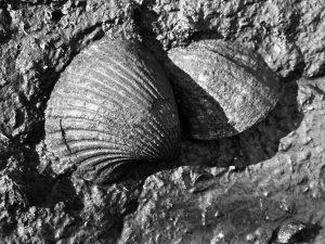 Our MDEQ, State Geological Survey scientists photographed these nearly 55-million-year-old marine fossil shells of the extinct clam, Venericardia bashiplata while visiting rock outcrops in the field in Meridian Mississippi earlier this week.
They were working with a team of visiting paleontologists from the McWane Science Center Museum in Birmingham, Alabama and the South Carolina State Museum. Their mission was to collect field samples to help them investigate the sharks, fishes, and other sea life that inhabited the ocean when the Queen City was beach front property in a time called the Eocene.
The fossils found here represent an ecosystem that developed in response to very important time in Earth history. This was about 10 million years after the mass extinction that killed off the dinosaurs along with about 75% of all life on our planet at the end of the Cretaceous period. The 10 million years that followed called the Paleocene, saw life struggle to rebound from the extinction event.
By the close of the Paleocene times the Earth was enduring a greenhouse environment of extreme warming. This is known by scientists as the Paleocen-Eocene Thermal Maxima. By the beginning of Eocene, the diversity of life on our planet exploded with new species, filling the environments and niches that were once held by the dinosaurs and their contemporaries on land and in the seas back during the Cretaceous period.
This explosion of diversity of life is well represented in the rich fossil beds of the Bashi Formation in found in Lauderdale County and that is what our team was there to sample. Several bags of marine sediments were taken from various outcrops along road cuts and ditches in the area. The sediments will be picked through under microscopes to find fossils during a long and careful laboratory study.
The sediments of the Early Eocene Bashi are rich with marine fossils shells, and also numerous tiny fossil teeth of ancient sharks, rays, and fish. Studies of fossils discovered nearby these sampling sites at the historic Red Hot Truck Stop, near what is now the Walmart in Meridian, revealed significant finds. Here some of the earliest fossil primates ever recorded in the entire world named by scientists, Teilhardina magnoliana were found to inhabit the area around this time.
The paleontological study this scientific team conducts will lead to a better understanding of the entire ecosystem and the individual animals that once inherited these ancient warm shallow seas from almost 55 million years ago. This is only possible through the rare window that is contained in these fossil rich beds that were deposited in an important time in this planet’s history, about Ten Million Years after the death of the dinosaurs.
Mississippi’s Giant Deer of the Last Ice Age
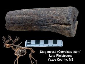 We continue our work here at the State Geological Survey to learn more about Mississippi’s geological past. Our efforts to learn about the ice ages of the Pleistocene epoch come through research by our MDEQ’s geologic mapping program, our collaboration with other scientists and museums, and most importantly our work with the public through the many fossil collectors we have here in Mississippi.
Though the glaciers that covered much of our continent, well to the north, never reached this far south, Mississippi was an integral part of the cyclic glaciations that shaped the geology of North America and our state during the Pleistocene epoch.
The Mississippi River was the main drainage for the glaciated region and was the focus of melt waters and even ice dam breaks that caused catastrophic flooding in the lower river valley of epic proportions. Sea levels on our Gulf Coast fell and rose drastically as the massive ice sheets came and went, falling up to 400 feet and exposing many miles of land now offshore as ice accumulated on land up to a mile in thickness.
Much of what we know about the environment during the Pleistocene epoch comes from studies of fossils left behind from that time period. Most of which are from the last glacial maxima (LGM) which saw glaciation at its height about 20,000 years ago. From our recent mapping studies, this is when sea levels last fell, and the Mississippi River carved out its current valley into the coastal plains in response to the growth of the glacial ice. We have been studying Mississippi’s ice-age environment from this time from plant fossil remains, particularly the abundance of well-preserved fossil pollen grains left behind in ancient sediments. These studies are being conducted by working with a team of paleobotanists from Delta State University, University of South Alabama, and the Smithsonian Institution and opening up a window into the plant communities of the forests, swamps, and prairies of our area during this much colder climate in Mississippi than that of today.
Many vertebrate fossil remains have been found by collectors throughout the state that date back to the last ice age. Because of the great diversity of fossil bones and the willingness of the public to share their finds with our researchers, we now know quite a bit about the animals that lived throughout Mississippi’s various ice-age habitats around the state. Many strange animals, now long extinct, roamed the lands here including saber toothed tigers, American lion, great short-faced bear, mastodon & mammoths, gomphotheres, giant tortoises, giant ground sloths, tapirs, and many more. Also, the first human inhabitants in North America entered into Mississippi during this time, exploiting the bounty of the ice-age environment.
Some particular animals whose fossil bones have been found here are rather rare and thus have remained a mystery as to the true nature of their presence here. Our scientists even have questions if they were really an integral part of our Mississippi ice-age ecology. This is particularly true for some ice-age animal fossil bones, such as mule deer that have been found along the Mississippi River here but have not yet been found anywhere else in the state. This is because their carcass could have traveled a considerable distance down the river from where they originally lived and died.
Another animal is an extinct species of extremely large deer called the Stag Moose (Cervalces scotti) whose bones and antlers were also once only known here from fossil collected along the Mississippi River. Stag moose was a true giant, approximately the size of a modern moose. It likely weighed up 1500 pounds and had huge complexly palmated antlers more impressive than any modern moose. They are better known from ice age fossil beds farther to the north, similarly to environments where modern moose are known to live today. It wasn’t until more recently that a Stag Moose fossil was found and reported to us in the Black Prairie region of northeast Mississippi. This find helped us to know that it indeed was once here, but it could have been from an individual that wandered outside its typical natural range as some animals are known to do today. What we really needed was additional fossil evidence for it to be more conclusive that the giant Stag Moose was actually a typical resident on Mississippi’s ice-age landscapes.
This evidence needed for further proof came in earlier this week from Yazoo County with fossil collector, William Pettis. An important friend of our research team here at the State Survey and the Mississippi Museum of Natural Science, William’s contribution of his finds has helped to greatly improve our knowledge of the fossils of Mississippi’s Loess Bluff Region.
On Wednesday, William met our survey geologists and the museum’s paleontologists at the Mississippi Museum of Natural Sciences to bring in some of his recent fossil finds for identification. Included in his collection was the base of a giant antler he found in the hills of the loess bluffs region near his home in Yazoo County. It was indeed the base of an antler from giant stag moose! This impressive and important ice-age fossil find helps us to cement stag moose’s presence on the ancient Mississippi landscape.
The giant stag moose would have been at home amongst the hardwood upland forests and grassy floodplains of the stream valleys in the loess bluffs regions. They likely would have also been prey for saber-toothed cats and American lions, and possibly also hunted by our earliest Paleoindian human inhabitants.
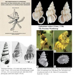 First Fossil Seashells Found in Amber.
Fossil insects are not uncommon in amber deposits worldwide. The first American amber insect was described by Cockerell in 1917. It was the caddis fly Dolopilus praemissus from amber in the Late Cretaceous Coffee Sand at its type locality at Coffee Landing on the Tennessee River in Tennessee. Other fossils from Cretaceous amber from the Turonian Raritan-Magothy Formation in abandoned clay pits at Sayreville, Middlesex County, in central New Jersey include a biting midge (Grogan and Szadziewski, 1988), the earliest known fossil ant (Agosti et al., 1997), and even a bird feather (Grimaldi and Case, 1995). Published fossils from Burmese (Myanmar) Cretaceous amber from Kachin, as of May 2021 (Ross, 2021), include 2038 species from 1,382 genera of which 1908 species are arthropods (insects). The first two marine gastropods from Burmese amber were published by Ting-Ting Yu, Bo Wang and Ed Jarzembowski (2019). These were named as the wentletrap snails (Family Epitoniidae) Epitonium (Epitonium) zhuoi and Epitonium (Papyriscala) lyui. So, what are the chances that these new Burmese fossil seashells would have anything to do with the Cretaceous Coffee Sand fosssils of Mississippi (publication at top left in composite figure)?
First, Epitonium is not just any seashell. Epitonium scalare (Linne, 1758) was such an exquisite and rare shell that, in the 18th Century, shell collectors valued it above precious stones (top right in figure). At the height of their value, these shells sold for several hundred English pounds apiece. Their value was so high that Chinese artisans counterfeited the shell using rise flour. Today they are not so rare and can be bought at a reasonable price, while those counterfeited by Chinese artisans are highly sought and valuable.
Back to Mississippi, in the publication on the Coffee Sand gastropods, I named several new species after family members, and these species have turned up in places around the world. They include Epitonium faearium named for my sister-in-law Terrell Fae Yonkers. E. faearium was found in the basal Mexcala Formation (lower Maastrichtian) in Guerrero State, southern Mexico (Perrilliat et al., 2000), as were many other Coffee Sand gastropods. The new species Punctiscalla melaniea, was named for my wife Mary’s niece Melanie. It was cited as being “very similar” to “Confusiscala” shutanaurensis from the Late Cretaceous Trichinopoly Group in the Ariyalur area of Tamil Nadu in southern India (Bandel, 2000, p. 79). The new species Lemniscolitorina yonkersi was named for my father-in-law and was compared with Lemniscolitorina kuhurense of the Trichinopoly Group, India (Bandel, 2000, p. 106).
The Epitonium, Epitonium (Epitonium) zhuoi Yu, Wang, and Jarzembowski, 2019 (Figure 3), was discussed in the publication’s introduction as follows: “The type genus Epitonium Röding, 1798 is abundant in records documenting the Cenozoic, e.g., Epitonium (Boreoscala?) sp. from the Eocene of Tanga (Ladd, 1970); Epitonium (Crisposcala) okinavensis Macneil, 1960 and Epitonium (Glabriscala) submaculosum Macneil, 1960 from the Pliocene of Japan (Macneil, 1960). However, Mesozoic records of Epitonium are rather sparse: Epitonium cf. faearium has been reported from the lower Maastrichtian of southern Mexico (Perrilliat et al., 2000); Epitonium sp. from the Cretaceous of Minnesota (Bergquist, 1944); and Epitonium faearium from (Figure 4) the Upper Cretaceous of Coffee Sand, Mississippi. In this work, we report the first record of Epitoniidae preserved in amber. Two new species, Epitonium (Epitonium) zhuoi n. sp. and Epitonium (Papyriscala) lyui n. sp., are described from Burmese amber dating from the mid-Cretaceous.”
Epitonium faearium is shown in the lower left of the composite figure with one adult and two larval shells. Epitonium (Epitonium) zhuoi is shown in amber and the reconstructed shell in lower right of the
figure. Congratulations to my sister-in-law Terrell Fae Yonkers in the citation of her fossil shell patronym Epitonium faearium in Yu, Wang, and Jarzembowski, 2019, First record of marine gastropods (wentletraps) from mid-Cretaceous Burmese amber: Palaeoworld, Volume 28, Issue 4, December 2019, Pages 508-513.
The Shell From Mars-by David T. Dockery III, State Geologist, MDEQ Office of Geology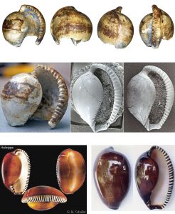
My first experience with the “shell from Mars” was around 1970 when I excavated one from an exposure of the Late Eocene Moodys Branch Formation in Jackson, Mississippi. It was a large globose fist-sized cowrie shell unlike any I’d seen before. Unfortunately, the anterior end of the shell had been eroded away when I found it. Before I published the molluscan fauna of the Moodys Branch Formation in 1977, an American expert on recent cypraeids (cowrie shells) placed the fossil cowrie as a new species of Notoluponia despite the fact that this genus was endemic to the Miocene of southern Australia. Based on his recommendation, I named the species Notoluponia ampla, ampla referring to the expansive aperture. The holotype of this species is shown in four views in the top row of the composite image. The aperture of the holotype and two other specimens are shown in the middle row of the image.
It was later that I met Luc Dolin, a French expert in fossil cypraeids, who recognized two mistakes. First, my beautiful new species had been previously named Cypraea jacksonensis Johnson, 1899, from fragmentary pieces. Secondly, it was neither a Cypraea nor a Notoluponia (both cowrie shells in the Family Cypraeidae) but was the extinct genus Sphaerocypraea (an egg cowrie in the Family Ovulidae). Sphaerocypraea was best known from the Eocene of Europe but was also found in the Oligocene and Miocene before its apparent extinction.
The baffling genus Sphaerocypraea was involved in a more recent tale of molluscan intrigue as told by Peter Dance, an author on recent seashells, in the December 2007 issue of the American Conchologist. Dance recounted his conversation in 2005 with Bruno Briano, a diver and shell dealer from Savona on the Italian Riviera. Briano told of a couple of strange shells he received from a Somalian fisherman in 1993. These shells had been dredged up by a Russian trawler operating somewhere near the coast of Somalia at a depth of 100 meters. Dance quoted Briano’s words, concerning his thoughts when he first saw one of the shells: “It was like a shell from Mars. A shell dreams are made of, a shell beyond imagining. I could not believe my eyes, it was so extraordinary. It made my heart beat faster.” Though Briano was not an authority on mollusks, he hurriedly published his two shells as a new genus and species, Chimaeria incomparabilis Briano, 1993. One of Briano’s two shells was selected as the type specimen of the species and placed in the French Natural History Museum in Paris. The holotype and another specimen are shown at bottom in the composite image as photographed by Guido Poppe, Museum National d’Histoire Naturelle, Paris.
Before Briano acquired his strange shells, another shell dealer, Donald Dan, traveled to Moscow in 1991 during the time of the Cold War to see a shell rumored to exist among various Russian shell collections that could neither be clearly identified as a Cypraea, Ovula, nor Marginella. As Dan told the story in the September 2008 issue of American Conchologist, he traded for one shell and paid for another shell of this strange new species. When he showed the shells to Luc Dolin in Paris, Dolin instantly identified them as belonging to the supposedly extinct genus Sphaerocypraea. Dolin explained, “It is truly a living fossil.” With Dan’s permission, Dolin immediately made drawings of the shells for the U.S. National Museum and began a scientific description of the new species. Dolin’s manuscript, with Gary Rosenberg of the Academy of Natural Sciences of Philadelphia as coauthor, was entitled “Sphaerocypraea neotenica n. sp., a Northeastern Indian Ocean Relict.” About a month after the manuscript had been reviewed by referees for publication, Dolin and Rosenberg had the misfortune of discovering Briano’s 1993 publication in which the new species was both named and misidentified (Briano’s new genus Chimaeria was later placed as a synonym of Sphaerocypraea). Dolin’s drawings were later published in Dolin and Ledon, 2002, Geodiversitas, volume 24, number 2, pages 329-347, figure 4 C-D.
Dan sold the two specimens studied by Dolin to a collector who agreed to donate them, along with a collection of other shells, to the American Museum of Natural History in New York. To appraise this collection, the American Museum selected an appraiser who was a shell dealer from Florida. The appraiser found the new species too tempting and pocketed one of the shells. He then advertised the shell for sale over an internet web site and sold it for $12,000 to Guido Poppe, a well-known shell dealer in Belgium. Poppe, unaware that the shell was stolen, resold it for $20,000 to an Indonesian shell collector in Jakarta. In 1997, the theft of a “remarkable and rare seashell” made news on both sides of the Atlantic. The Florida shell dealer was arrested for having committed a federal offense, and Poppe was detained by U.S. authorities when he passed through Los Angeles. Eventually, the Indonesian collector was reimbursed and returned the stolen shell.
The return of a rare stolen shell to the American Museum would be a happy ending to this story if not for the misfortunes of those who admired or coveted the “shell from Mars.” Dan gave an account of these events in American Conchologist as noted above. Bruno Briano, who named the new species, had an extensive stock of specimen shells stolen from a shell exhibition in Italy. Thieves then broke into his house and stole additional shells. Briano’s remaining stock of shells was buried in mud when a mountain stream overflowed its banks and flowed into his home. Briano’s young son convinced him to sell his “unlucky” Sphaerocypraea specimen, which he did to a Japanese collector. Shortly afterwards, the collector’s family suffered disastrous results from the Kobe earthquake, which occurred on January 17, 1995. The Indonesian collector who paid $20,000 for the specimen sold by Poppe moved his communication-cable business to an impressive new building in Jakarta. Shortly afterwards, the building was destroyed during the Jakarta riots of May 1998. When Dan agreed to write the story of the stolen shell, he was frustrated in his search for a picture of the specimen. A Belgian shell enthusiast from Ghent, Yves Teryn, agreed to send Dan a picture of the shell he took at the Lutry, Switzerland, Shell Show in 1993. Sadly, the day after the picture was sent by email, Teryn’s computer crashed, and the image and five years of research notes were lost.
Resurrecting Color Patterns in Fossil Shells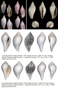
Scaphella junonia (Lamarck, 1804) is the State Seashell of Alabama and lives at depths of 60-120 feet in the waters of the Gulf of Mexico. The species is in the family Volutida, a family distinguished by their distinctively marked spiral shells with deep columnar plaits. The color pattern of Scaphella junonia consists of rows of rounded rectangular dots. Four variations of this dot pattern are shown in the upper left of the composite image. In the upper right, is the fossil Pliocene shell of Scaphella floridana from La Belle, Florida. The faint color pattern of doted rows can still be seen on the fossil shell. But what about even older fossil shells that show no color pattern at all? Can these old color patterns be resurrected? Sometimes they can. When the fossil shell is photographed under ultraviolet light the old color pattern may appear. In ultraviolet photographs, the color pattern appears brighter than the background, so a negative of the photograph must be made for the pattern to appear dark and the background to be light.
The bottom two shells of the composite image are specimens of the fossil Eocene species Caricella polita (Conrad in Wailes, 1854) from the Moodys Branch Formation of Jackson, Mississippi. These specimens show no color pattern in natural light but do under ultraviolet light. Caricella has a shell very much like Scaphella and is possibly a synonym of that genus. It has a similar fusiform shape and strong columnar plaits. It generally differs in its more bulbous whorls and shorter spire. But did these ancient shells have a similar color pattern? They did! One image in the multiple views of each shell was photographed under ultraviolet light and is shown as a negative of the original picture, clearly showing the doted pattern of Scaphella. To see more fossil Eocene shells (some photographed under ultraviolet light to show the color pattern) click on the link below.
https://geology.deq.ms.gov/surface/fossils/
Pelahatchie Bay Park Rip-Rap at the Reservoir
There are very few places in Mississippi where fossils just can’t be found. There are also a number of unusual and unsuspecting places they can be found. Many are found where they are deposited naturally, but in some cases they are not, such as graveled driveways and playground. There are more such unnatural places that that many of us see everyday, but don’t know to look.
Today’s Fossil Friday takes us to Pelahatchie Bay Park looking at the rip-rap placed along the shores of Ross Barnett Reservoir in Rankin County, Mississippi. This December-2023-Website-Org-Chart 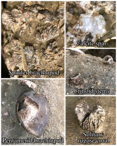 grey colored dolomitic limestone is originates from the Tuscumbia Formation and is mined as an important source of aggregate in extreme northeast Mississippi and Northwest Alabama above the banks of the Tennessee River.
Limestone from the Tuscumbia Formation is an important resource used in civil engineering projects throughout the state. It is one of the most commonly used primary aggregate utilized by engineering projects in Mississippi by MDOT, USACE, and many other county, local, and private construction projects. It is widely used for rip-rap for erosions control, slope stabilization, as well as for road aggregate. Tuscumbia limestone can be seen used in engineering projects along our roads and highways, dams, bridges & overpasses, along lake shores, improved drainages, and river dikes.
The Tuscumbia Limestone is Mississippian in age from the Paleozoic era, deposited in a shallow tropical some sea about 340 million years ago. This long before the days of the dinosaurs. Invertebrate fossils of the sea creatures that inhabited the ancient sea such brachiopod shells, corals, bryozoans, and crinoids are well-preserved throughout the Tuscumbia limestone.
Over time, minerals can form such as chert, chert, calcite, and even fluorite form in the limestone from a process called diagenesis from the slow movement of mineral-rich groundwater through the rock. These minerals, particularly chert can replace these fossil and make them more weather resilient than the limestone. As the limestone is exposed to the elements, it tends to slowly chemically weather and dissolve away. This tends to exposes the mineral-replaced fossils along the surface of the rock, like the one’s photographed here by our MDEQ, Survey geologists while conducting field work in the Ross Barnett Reservoir area.
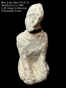 The Bay Lake Statue
Paleontology is an essential aspect in the proper scientific interpretation of the ancient prehistoric indigenous material archaeological record here in Mississippi. This can be highlighted by the examination of The Bay Lake Site statue 19-N-3 from Sunflower County Mississippi by our MDEQ State Survey Geologist and fellow researchers from the L.B. Jones Collection Charitable Trust.
The Bay Lake site is predominantly a Mississippian cultural period occupation site likely inhabited between ca. 1000-1500AD.
The Bay Lake statue was discovered by Jack Mims is carved out of a single block of stone and it is approximately 13cm tall and 8cm wide. It is described by L. B. Jones Charitable Trust scientists as depicting a human figure in the kneeling position with both hands positioned over each knee. He/she seems to be adorned with an ear spool and a headdress or hairstyle while a “collar” appears draped around the shoulders just below the neck. This style is seen throughout the southeast during the Mississippian Period.
The Mississippian Culture transitioned out of the Woodland Cultural period here in the southeast sometime around 800 A.D. The Mississippian culture established direct influence over a broad area along the Mississippi valley from Illinois through Mississippi and east across the coastal plain into Florida. This great societal organization was notably one of richest cultures and art traditions in the history of the entire world. It reached its peak of expansion sometime between 1500-1660 AD. and eventually collapsed around the time of early exploration of the new world by Europeans.
Careful examination of the Bay Lake statue artifact was conducted at the Museum of the Mississippi Delta in Greenwood by the team of scientists. They determined that it was made from a type of sedimentary rock called fossiliferous limestone. Careful study and identification of the fossils that it contained revealed that it was dominated by the large foraminifera Lepidocyclina supra. Also, an ichnofossil fossil of a benthic invertebrate burrow cast is exposed in a fracture along the face of the statue that can be attributed to the decapod ichnogenus, Thalassanoides.
The study concluded that the Bay Lake statute was made from Glendon Limestone. This is a lower Oligocene age limestone which is a member of the geologic beds known as the Vicksburg Group. It a hard, fossiliferous to semicrystalline rock that terminates to outcrop along the base of the loess bluffs from just south of the confluence of the Mississippi and Yazoo Rivers in Warren County, north to just a couple of miles south of Satartia in Yazoo County. The outcrop also continues east through central Mississippi along a line from Brandon to Waynesboro.
These ledges of limestone produce the longest stretch of waterfalls in Mississippi along the numerous small creeks and tributaries that drain the loess bluffs into the Delta. No doubt these majestic places drew special attention from the Native American inhabitants of the region and were likely considered sacred places by the indigenous people.
The limestone that was collected in this outcrop region by the Native American peoples were used throughout prehistoric cultural time for carved tools and intricate artwork. Finely crafted zoomorphic pipes crafted of the favored Glendon Limestone have been found traded to other ancient archaeological sites throughout much the Southeastern United States. The examination of many of these artifacts in other museums throughout the United States have also included studies that were done in coordination with MDEQ’s State Survey geologists to help describe and source them by their fossil content.
More on Mississippi’s native lithic materials: https://www.mdeq.ms.gov/geology/work-areas/surface-geology/lithic-materials/.
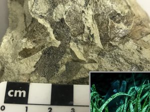
Seagrass Fossils
Plant fossils are an important part of fossil record. Paleobotanical specimens can be fossil leaves, silicified or lignitized wood, or fossil pollen. Mississippi’s geology contains a wealth of paleobotany for scientific study, dating back 100’s of millions of years to the Paleozoic era, long before the days of the dinosaurs.
Paleobotany reveals important details about past climates, environments, and habitats recorded as a story throughout the different layers or our geology. Most of these layers we study plant fossils in were deposited in terrestrial environments, one’s that formed in river and deltas or in estuaries and swamps. Plant fossil studies fill important gaps between the marine layers that our Survey geologists more traditionally use paleontology for in order to decode the stratigraphic record for geologic mapping.
Very rarely in the marine geologic record do plant fossils occur, other than pieces of driftwood swept offshore and carried by the ocean currents. This common type of plant fossil gives us very little insight about the geology because they are out of place and very little preserves as they are quickly colonized by marine organisms. Aquatic plants, though very rarely preserved, were certainly very much a part of ancient marine ecosystems. It is exciting when our MDEQ Survey geologists find them in the marine fossil record because of what more that they can tell us about an ancient environment.
Today’s Fossil Friday brings us near downtown Brandon, Mississippi in Rankin County. Limestone outcrops of the Vicksburg Group, full of marine fossils such as sea shells and sharks teeth, have been known from the area and utilized since the earliest indigenous inhabitants of prehistoric times. During the historic times, these limestones outcrops were an important economic resource and have been mined heavily for cement manufacture and agricultural lime.
The limestones of the Vicksburg group were deposited some 30 million years ago when much of the southern half of Mississippi was covered by a warm shallow sea in the early part of the Oligocene epoch. Our Survey geologists revisit these outcrops regularly to look for new fossils to study that may have been uncovered by natural erosion or disturbances caused by development.
On two such recent occasions, our geologists discovered something new. One at a frontage road construction along HWY 80, which uncovered an unusual thin sandy layer between beds of limestone that was sampled. Once these samples were brought back to our laboratory it was discovered to contain an enormous density of fish fossils, particularly otoliths (fish ear bones). The second discovery was made on the south side of I-55, off of HWY 18 near the Pepsi plant, along a ditch that was being constructed, exposing rarely-preserved marine plant fossils in the limestone.
Together, these two finds tell an important story. The plant fossils were identified as sea grasses. The sandy layer, rich with otoliths, were dominated by a small species of congrid eels. Though the sea grass fossils were found at a different outcrops that the eel fossils, but nearby, a likely correlation can be made between them. Sea grasses trap sands shifting in the shallow open ocean currents and eels like these today thrive in patches of sea grasses. Dugong fossils are also commonly found in the fossil record at these same outcrops. The Seacows of today graze on these sea grasses like these found in fossil record here. This makes this discovery of the fossil sea grass an important clue in piecing together the broader fossil record at these two outcrops and in understanding this ancient environment.
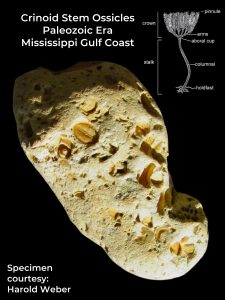
A Journey From One Ocean to Another – Separated by Hundreds of Millions of Years
Long before there was a Gulf of Mexico, there was a warm tropical sea just north of Mississippi about 300 to 500 million years ago during the Paleozoic era. The fossil-rich limestones this sea left behind can be found in Missouri, Arkansas, Tennessee, Kentucky, Alabama, and even in parts of Tishomingo County, Mississippi along the bluffs of the Tennessee River.
Over time this sea gave way to coal swamps and eventually dried up. During the breakup of the supercontinent of Pangea a new sea began to form to the south as North and South America moved farther apart. This formed the Gulf of Mexico.
Subsequent uplift of the continent over time further exposed this old sea floor. Erosion transported these ancient marine Paleozoic era fossil-bearing rocks full of the remains of invertebrates down the rivers draining the mid-continent down the Mississippi Embayment towards the Gulf of Mexico. The geology of our state, at its simplest, is this sedimentary record of the Mississippi Embayment and the Gulf of Mexico filling up and responding to changes in sea level. The abundance of Paleozoic era fossils that can be found in our gravels are a record of ancient streams and rivers that cross Mississippi on their way to the Gulf of Mexico. Fossils brachiopods, bryozoan, corals, and most commonly crinoid that all predate the days of the dinosaurs can be found in our gravels.
Collecting these fossils continues to spark curiosity of local rock and fossil hunters of all ages. For our State Survey geologists, these gravel fossils are an important tool for studying geology. They can tell us the story of shifting drainages across different bedrock areas to the north and how that changed over time.
Today’s Fossil Friday brings us the discovery othef a crinoid fossil rich stone from a gravel walkway on the Mississippi Gulf Coast by Harold Weber. It was identified by MDEQ’s Office of Geology staff. Crinoids are echinoderms, or ancient relatives of starfish and sand dollars. They are still alive today, making them true living fossils. They have been inhabiting this planet for almost 500 million years.
Harold’s specimen is rock known as crinoidal chert, a type of rock that was once the sea floor that formed from sediment dominated with the skeletal remains of fossil crinoids. Complete fossils of crinoids are rarely preserved intact. Individual segments called ossicles, partial stem segments, and rarer calyxes are some of the most abundant chert gravel fossils found here in Mississippi.
The story of Harold Weber’s fossil is a remarkable one. A journey that spans hundreds of miles, across a great expanse of time, and from one ocean to another.
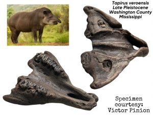 Fascinating Tapir Fossil Specimen From Ice Ages Unearthed in Mississippi Delta
Tapir had been a part of the North American Landscape for some 50 million years since a time called the Middle Eocene. These pig-like megafauna thrived in both North and South America until the end of the last ice age some 12,000 years ago. They still exist today, thriving only in jungles and thick forest regions of South and Central America and Southeast Asia.
Only similar in appearance to modern pigs, they are part of a group of mammals called Perissodactyla which are odd-toed ungulates, making them closely related to horses and rhinoceroses. Tapirs are herbivores. They subsisted on various plants, nuts, and fruits of wooded areas. They once ranged in North America from Canada to the Gulf Coast and from the Atlantic to the Pacific Ocean.
During the late Pleistocene here in Mississippi tapir likely grew to reach 400lbs. They would have been ideal prey for a host of predators that occupied the landscape including American lion, saber toothed cats, dire wolves, and even the human inhabitants during the Paleoindian cultural period.
This remarkable fossil specimen of a pallet with teeth was collected by Victor Pinion off the Mississippi River in Washington County, Mississippi and identified by MDEQ’s Office of Geology staff. This specimen can likely be attributed to the species Tapirus veroensis which inhabited a wide range in the southeast and mid-western United State.
The late Pleistocene wooded bottomlands of Mississippi’s Delta Region were a bounty for its earliest Paleoindian inhabitants that occupied the area. This rich diverse environment not only include tapir but giant giant bison, mastodon, mammoth, giant ground sloths, elk, deer, and horses along with the host of predators mentioned above as evidenced from the rich ice-age fossil record of Mississippi’s Delta region.
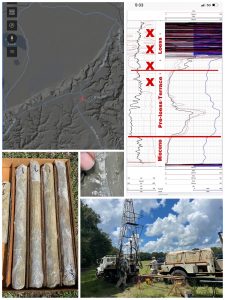 The Rodney Terrace: Unraveling the Geology and Environment of Southwest Mississippi During the Ice Ages
The revelations garnered from recent geological mapping work on the timing and evolution of the lower Mississippi River Valley, has led the Mississippi Geological Survey researchers at MDEQ (Office of Geology) to the development of a new framework to better understand the environmental effects of the cyclical glaciation on the lower Mississippi River valley and its geology. Their work has identified Pleistocene deposits containing a host of well-preserved fossil flora, fauna, and even early cultural remains that are being studied and just recently being understood in their proper scientific context.
Core samples were taken last field season during a drilling project to study an uninterrupted stratigraphic section of an ancestral Mississippi River Pre-loess Terrace Deposits in Jefferson County, MS. This terrace is blanketed by glacial silt called loess. The loess masks a perfectly preserved ancient land surface called a paleosol and surfacial clay stratum from the alluvium of the ancestral Mississippi River. This is a remarkable window into a preserved land surface deposited during the last interglacial stage of the Pleistocene epoch. This relic land surface was once the Mississippi River’s floodplain just before the river abandoned this level. Radiometric dates of the core samples revealed that the Mississippi River began cutting through this terrace level into its current entrenchment in the coastal plain because sea levels dropped drastically during the last glacial advance of the Pleistocene some 20,000 years ago.
Outcrops of this first terrace of the Mississippi River have been mapped further south into Adams County by the Survey’s research team and have also equated it to the “Natchez Formation” that was once described in outcrops along the Mississippi River bluffs in the early geological literature. The extent and context of this geologic feature, that we now call the Rodney Pre-loess Terrace, has only now been recently understood by survey mapping and test hole drilling.
The expression of this loess-draped terrace surface is heavily dissected today by erosion. But during the last glacial episode, it hosted a lush broad and level prairie-like environment overlooking the Mississippi River and was bordered to the east by the older aggressive loess draped eroded uplands of the river’s valley wall.
Thanks to fossil and artifact collectors in the area, a host of well-preserved late Pleistocene megafauna fossil remains have been recovered and documented from the Rodney Terrace. These include mastodon, American lion, giant ground sloths, tapir, extinct bison, extinct horse, along with the stone artifacts of the early PaleoIndian Pleistocene human inhabitants that occupied this broad plain overlooking the Mississippi River.
Over the last ten thousand years, this terrace feature has undergone significant erosion but has continually been considered ideal for human habitation, even through later cultural periods. Iconic prehistoric archaeological sites, ancient city centers, & historic sites can be found along the loess-blanketed surface of the Rodney Terrace such as Feltus Mounds, Anna Mounds, Windsor Mounds & the Windsor Ruins, and the historic City of Natchez & Fort Rosalie.
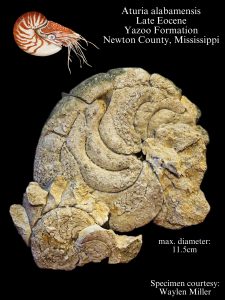 Fossil bones of an ancient alien sea creature?
Todays Fossil Friday features a large specimen of the fossil nautiloid, Aturia alabamensis. It was collected by Waylen Miller on his property and identified by MDEQ’s Office of Geology staff. This amazing fossil is from an outcrop of the Late Eocene age Yazoo Formation in Newton County, Mississippi. A number of other fossils demonstrating an entire fossil ecosystem of the ancient sea bed that once covered Mississippi were also found by Waylen. The type of preservation of Waylen’s nautiloid fossil is called a “stienkern”. To the untrained observer it looks absolutely alien, resembling a curled set of articulated vertebrae of an unknown strange beast. In fact they are not at all bones, but the internal cast of the individual chambers of the nautiloid’s shell, called septa. Waylen was able to successfully reconstruct the steinkern of the nautiloid and below to the right in the photo are the articulated internal septa from the same specimen. For over 300 million years of our earth’s history the worlds oceans were teeming with shelled cephalopods, called ammonites and nautiloids. These diverse groups of predatory mollusks are relatives of modern octopus and squid. They swam and hunted in both shallow marine waters and the open seas. Species of these strange creatures ranged in size from fractions of an inch to true sea monsters with shells larger than 8 feet in diameter and likely weighing more than a thousand pounds. Today ammonite and nautiloid shell fossils are highly-prized by collectors. These iconic fossils have distinctive radiating patters (called) sutures that range from simple in nautiloids, to amazingly complex fractal patterns in ammonites. Their shells were constructed of beautiful mother-of-pearl. This fossil shell material is also prized today as an iridescent gemstone, called “ammolite”. Ammonite and Nautiloid shell fossils are very important to mapping geologists and paleontologists in the field. They are excellent time boundary indicators because of their rapid rate of evolution and world-wide distribution in the marine sedimentary record. Ammonites and nautiloids lived together until the extinction event that killed off the dinosaurs at the end of the Cretaceous period. At the end of the Cretaceous period a meteorite struck the Gulf of Mexico, killing 75% of all life on earth. This included all of the non-avian dinosaurs on land and all of the ammonites in the worlds oceans. Nautiloids however, did survive this catastrophe and continued through the paleontological record up to today.
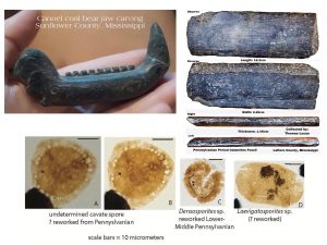
Cannel Coal, Archaeology, Geology, and the Mississippi River
Cannel coal is a type of type of bituminous coal more accurately classified as a grade of carbonaceous shale. This black claystone is considerably durable compared to other types of coal. It has been exploited worldwide throughout antiquity for both its ease in carving and in maintaining a black, highly-polished surface. In North America, cannel coal comes from Carboniferous age bedrock deposits that are dominated by the fossil plant remains, Lepidodendron and Calamities. The Mississippi River and its northern tributaries drain this Paleozoic bedrock region, therefore cannel coal can commonly be found as a resource amongst the Mississippi River gravels. Cannel coal’s utilization by prehistoric Native Americans cultures is evidenced by stunning artwork and some unusual utilitarian artifacts found here in the Mississippi Delta region. Recent sampling done for our geologic & geoarchaeological mapping this year in the northwest Delta has shown the influence of Mississippi River cannel coal to be important on a microscopic scale. Paleoindian and Early Archaic sites are located along parts of the ancient, abandoned Mississippi River system. We collected lignite samples below agricultural fields from nearby ancient abandoned oxbow channels to better understand the environment the first people to the Delta Region inhabited. The fossil pollen and spore samples they contained were studied this summer at Delta State University. Ancient Paleozoic fossil spores once preserved from cannel coal were positively identified amongst more geologically contemporary paleobotanical microfossils. These undoubtedly were once carried by seasonal river floodwaters into these oxbow lakes and became part of the lake’s sediment. This much in the way Paleozoic gravel fossils are washed along the river’s gravel bars today. We know that they were derived from cannel coal because other forms of coal notoriously preserve fossil pollen and spores very poorly in contrast to these claystones. The presence of this more ancient paleobotanical microfossil assemblage can help us to understand the environmental influences to the lake sediments while studying the more contemporary pollen and spores found in the lake sediments will help us to understand the ecology around these ancient lakes when they existed.
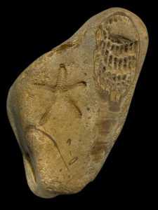 Gravel fossil hunting is a state-wide pastime in Mississippi enjoyed by people of all ages. Whether it’s a young child sorting through the gravel for geologic treasures on the playground at recess or the curiosity of an adult picking up a rock that caught their eye out in their driveway, it is often the first introduction to paleontology for most folks around here.
Our chert gravel deposits in Mississippi eroded from ancient limestone bedrock sources north of here, up in the mid-continent, and were brought down and deposited by rivers as they once crossed the coastal plain on their way to drain into the Gulf of Mexico.
Patterns throughout Mississippi’s chert gravel was created by the abundant fossils remains of ancient Paleozoic era sea creatures. These fossils are hundreds of millions of years old, long before the days of the dinosaurs. Collecting these fossils continues to spark the curiosity of our local rock and fossil hunters and folks of all ages today.
For our geologists these gravel fossils are an important tool for studying the geologic history of these gravel and the shifting bedrock areas of these ancient drainages that brought the gravel down here over time.
This prized gravel fossil specimen of the Paleozoic era starfish was found by John Robison of the Mississippi Gem and Mineral Society in Copiah County. It was identified here at MDEQ as the species Compsaster formosus by the State Geologist, invertebrate paleontologist Dr. David T Dockery, III. It was featured in our book Geology of Mississippi, in 2016 and recently photographed again by our Office of Geology staff back in March of this year.
Starfish are echinoderms related to sea urchins and sand dollars that belong to the class Asteroidea. Starfish are truly living fossils. Their ancestry can be traced back to the Ordovician period, more than 400 million years in the fossil record. This specimen is from the Mississippian period and is about 350 million years old. They shared the sea floor with animals like crinoids, which they are also related to. While starfish fossils are incredibly rare, crinoid fossils are the most abundantly found fossil in our Paleozoic gravel fossil record here in Mississippi.
This amazing fossil-bearing gravel clast also exhibits an exceptionally well-preserved fossil of solitary rugose coral demonstrating detail of the animals mineralized external skeleton eroded in cross-section. These fossils from the Paleozoic era are frozen in time from when they were once buried together on the ancient sea floor.
Spectacular gravel fossil finds like this rare starfish are often people’s first introduction to the science of Paleontology in Mississippi. To help facilitate this widespread interest for people of all ages, MDEQ has published an educational resource for gravel fossil hunters called “Rocks and Fossils Found in Mississippi Gravel.” It is available for free download: Rocks And Fossils Found In Mississippi’s Gravel Deposits – MDEQ.
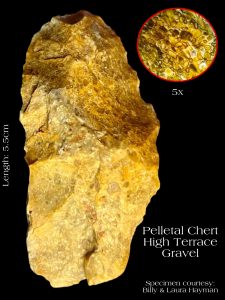 A Window into South Mississippi’s Lithic Materials: A Pelletal Chert Artifact From Mississippi Gravel
Pelletal chert is a chert-replacement of pelletal carbonate mudstones derived from Paleozoic bedrock that once formed in ancient tropical, near-shore marine environments. Today’s example comes from an ancient, knapped stone artifact found in Simpson County by Billy and Laura Hayman. It was manufactured from the the High Terrace gravels which occur naturally in the area and identified by MDEQ, Office of Geology staff earlier this week.
Most geologists that study carbonate petrology and how these types of sediment form think that these pellets are an accumulation of tiny fossils, called coprolites. They are thought to be the fecal products of abundant invertebrate organisms because of their consistent size, shape, and typically high iron content.
Pelletal chert forms from the micro/cryptocrystalline silica replacement of pelletal limestones. They were carried here from ancient Paleozoic era bedrock sources, up in the mid-continent, by ancient rivers flowing across Mississippi on their way to the Gulf of Mexico. The most common pelletal chert types are pelletal jaspers, that are a distinctive red or green in color. The differences in color of pelletal jaspers are derived from the state of the iron impurities that they contain. Red is the most found variety of pelletal jasper and gets its color from iron minerals in an oxidized state. The less common color is green. This is also due to the presence of iron minerals, but in a reduced state.
Our MDEQ geologists play an important role in understanding and helping to interpret Mississippi’s rich prehistoric archaeological record. Pelletal jaspers were utilized for thousands of years by Native American cultures for ground and polished ornaments found Mississippi. They were utilized in the ancient Native American lapidary industry for such items as beads and effigies. This tradition likely began in the Middle Archaic cultural period and saw its height in the lower Mississippi Valley during the Late Archaic cultural period.
Rarely is any type of pelletal chert seen knapped in prehistoric archaeological assemblages. This is because of its texture and inherent mineral impurities that generally prevents any consistency in the propagation of a conchoidal fracture.
This particular specimen of pelletal chert was selected for tool manufacture. Maybe this was for its color that is more like other honey-colored cherts typically utilized in knapped biface tool production. Maybe it was noticed for its complex patterns in the stone and selected for aesthetics. Or maybe even both. Either way, it quickly proved to be inadequate by the manufacturer because of its mechanical properties and never made it past the early stages of knapped stone tool manufacturing, thus was discarded. The opposite face (not shown) still retains much of the natural cortex of the stone.
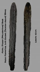 The geologic formation, the Yazoo Clay, is infamous for people living in central Mississippi. This is especially the case in the more densely populated areas in and around Jackson. The Yazoo Clay is better known for its potential to cause millions of dollars in damage to buildings, homes, roads, and other infrastructure.
The clay particles that make up the Yazoo Formation consists of a calcium rich mineral called montmorillonite. The microscopic clay minerals are loosely bound to one another which allows water molecules to readily intervene between them. This geochemical property allows the clay to greatly expand during wet conditions and shrink greatly during dry conditions. This shrink and swell property of the Yazoo Clay qualify it as geohazard in Mississippi. Because of this, it has been the focus of detailed study and geologic mapping efforts by MDEQ’s Survey Geologists.
The Yazoo Clay consists of deep marine sediments that accumulated on the sea floor some 38 million years ago at a time called the Eocene epoch. What might surprise many people is that the clay can perfectly preserve fossils from ancient animals. The clay locked in time many of those that once lived there. These include fossil remains of some of the largest animals on earth, such as complete fossil skeletons of giant basilosaurs and fossil teeth of some of the largest sharks to ever live. This makes the Yazoo Formation a treasure trove for fossils for our state scientists as they study and learn through this rare window into our natural history that the Yazoo Clay provides.
Our scientist’s latest fossil finds from the Yazoo Formation came earlier this week while hosting MSU Extension Service agents along the Pearl River near Jackson for a full day of geologic science field training. The experience combined exercises in river kayaking, geology and the environment, and rock and fossil hunting to facilitate youth training in the newly formed 4-H Canoeing and Kayak Club, and Geo-Arch Clubs.
During the field trip, the group visited geologic outcrops of the Yazoo Clay exposed along the river. A layer of seashell fossils in the clay helped to demonstrate that the past environment was once an ancient seabed.
Highlighted in today’s #fossilfriday is one of the discoveries made during the training field trip. It is a delicate 38-million-year-old fossil stingray barb from the Late Eocene age Yazoo Formation. With the great educational experience, the agents had, they can bring back with them the geologic knowledge gained about our state to the youth involved in their 4-H program. This fossil stingray spine will be donated to the Mississippi Museum of Natural Science’s vertebrate paleontology collections for future study and a great way to commemorate the agent training field trip.
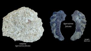 A Late Cretaceous Coquina of Fossil Oysters from Northeast Mississippi
Coquina is an unusual and distinctive type sedimentary rock. It is made up entirely of shell fossil and contains no other sediment. Coquina forms in very specific environments that concentrate mollusk shells by the movement of water. This typically occurs in areas with relatively low sedimentation rates. This is because the energy carries the finer sediments away to calmer parts of the depositional system. Such environments include those constantly subject to wave action in near shore environments, as well those affected heavily by ocean current.
Coquina was first described as a rock type on the east coast of Florida. The colonial Spanish quarried it locally for large stone blocks to build military fortifications and other buildings as early as the late 1500’s. The coquina rock that made up the walls of these forts became infamous for the property of absorbing the projectiles of enemy artillery fire.
Coquina can be found dispersed throughout much of the fossil record. Coquina also varies highly in appearance. This is because the types of fossils that make each occurrence up are unique to each geologic setting, paleoecology, and time period. Coquina beds in the geologic record are very important to mapping geologists for the valuable information they provide the field scientist.
This post brings us an example of thin bed of coquina collected by MDEQ’s Office of Geology staff during geological survey field work near West Point, Mississippi. It is from the late Cretaceous (early Campanian) in age and is composed entirely of the shells of a small fossil oyster, Agerostrea falcata. These thin shells were concentrated by currents in the bottom of a shallow sea in what is now the Mooreville Formation in Northeast Mississippi. Over time and with the weight of deep burial by younger sediments, the shells were crushed, distorted, and naturally welded together to form a coquina bed.
Also photographed in today’s post ion comparison, is a perfectly preserved individual articulated fossil specimen of Agerostrea falcata. It was collected nearby from an adjacent chalky clay bed at different horizon at the same 82-million-year-old fossil rich outcrop.
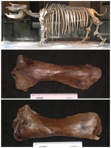 Teleoceras Medicornutum from the Middle Miocene (Barstovian) of Southwest Mississippi
Fossils are incredibly important tools for geologists. They are essential for unlocking the details of deposits and in determining both environment and time. This is especially true in parts of the geologic section that seem largely barren of fossils. In those cases, every detail can offer scientists valuable world clues.
A good case study for this is the geology of south Mississippi. Here the Grand Gulf Group outcrops from the southern edge of capital city in Jackson to the Gulf of Mexico. Sedimentary deposits of Grand Gulf Group span the time from the late Oligocene to Pliocene in age and reach a maximum thickness of three to 5,000 feet of section.
Determining and constraining the age and stratigraphic boundaries of the individual formations that make up these deposits has been a major challenge for geologists for a very long time. This is because this part of the geologic section is almost completely terrestrial and contains very few fossils.
Plant fossil sites are the most common occurrence in south Mississippi. They are important environmental indicators, but they lack the necessary information that fossils of marine organisms can tell us about their age. The occasional find of the rare occurrences of terrestrial vertebrates in south Mississippi has recently been able to give us this great insight.
A happen-chance finding of a fossil bone at a hunting camp near Meadville, Mississippi in Franklin completely changed our understanding of the geology of the area. It was brought to the attention of the camp by one of the members and was dismissed as a cow bone. Not satisfied with that answer, he brought it to the attention of the Mississippi Museum of Natural Science in Jackson, who immediately contacted MDEQ’s Mississippi Office of Geology for a joint investigation of the find.
The find turned out to be the fossil leg bone of a type of ancient rhinoceros. Rhinoceros are part of a group of mammals called perissodactyls that evolved right here in North America about 55 million years before spreading to other parts of the globe. Rhinoceros became extinct in North America about five million years ago. So how does this find help us to better understand the geology of south Mississippi?
Being able to identify the fossil rhinoceros down to a specific species answers many questions. This fossil find was carefully studied and shared with other researchers to help narrow it down. The fossil bone was specifically from a stout legged rhinoceros named Teleoceras that lived from the Miocene to early Pliocene. These animals were semi-aquatic and lived along coastal swamps and freshwater river deltas similar to modern hippopotamuses.
Because this fossil bone was so well-preserved it could be narrowed down to a specific species, Teleoceras medicornutum. This animal lived during a narrower time frame in the middle part of the Miocene epoch called the Barstovian, which is the North American Land Mammal Age that lasted from 16.3 to 13.6 million years ago. From this one rare fossil we were able to reconstruct the geologic age, depositional environment, and reconstruct an ancient habitat for this part of the geologic section where before this discovery we knew so little about.
 Pelletal Jaspers From Mississippi Gravel
Pelletal Jaspers are a chert-replacement of iron-rich pelletal carbonate mudstones derived from Paleozoic bedrock that once formed in ancient tropical, near-shore marine environments. Today’s example comes from the Pre-loess Terrace gravel photographed by MDEQ, Office of Geology staff in the field this week in Yazoo County, Mississippi. Most geologists that study petrology and how sediment forms think that pellets are an accumulation of many tiny fossils, called coprolites. They are thought to be the fecal products of invertebrate organisms because of their consistent size, shape, and very high iron content. Pelletal jasper forms from chert replacement of Pelletal limestones and were carried here from Paleozoic bedrock sources up in the mid-continent by ancient rivers. Two types of pelletal jasper, red and green, are both available in the Pre-loess Terrace gravels along the bluffline and are also a constituent of the Mississippi River gravels. The differences in color of pelletal jaspers are derive from the state of their iron impurities. Red, the most found variety, like the example in today’s Fossil Friday. It gets its color from iron in an oxidized state. The less common color, green, is also due to iron, but iron in a reduced state. These high-quality jaspers were culturally utilized for a few implements and ornaments in Mississippi’s rich prehistoric archaeological record. Most notably, in the ancient Native American lapidary industry that began in the Middle Archaic cultural period and saw its height in the lower Mississippi Valley during the Late Archaic cultural period. Due to the texture and color variety of pelletal jaspers, they often can be mis-identified in describing artifacts from our ancient archaeological record. The gravel clast-size pelletal jasper can range widely, from small pebbles to large cobble size specimens. Other types of local jaspers found naturally here (and similarly utilized from our gravels) are banded-iron formation jaspers (originating from bedrock much further up the watershed of the Mississippi River) and chert jaspers (which are basically just red chert, either natural or from heat-treatment).
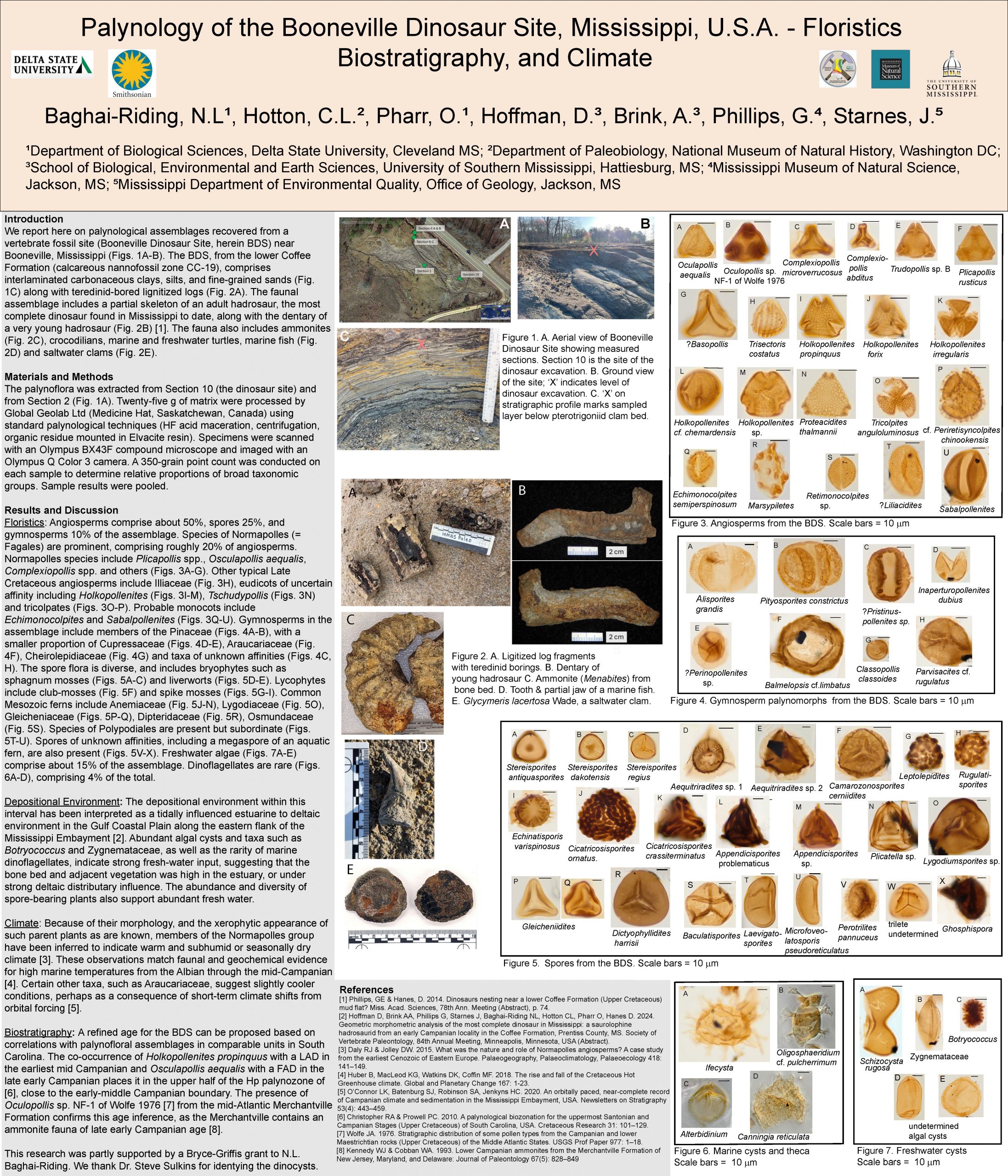
Excavation of a Cretaceous Mosasaur Fossil by MDEQ’s Office of Geology for the Mississippi Museum of Natural Science
The discovery of an important mosasaur fossil was made in July of last year by the Mississippi Museum of Natural Science’s paleontologist and their Special Events coordinator as they were passing through an area that the Museum had worked several years ago for studies on Pleistocene fossils. They had stopped again to visit this old fossil research haunt to look for more Pleistocene age fossils eroding from the alluvium outcrops along a small drainage through a vast expanse of agricultural fields. The floor of these small drainages in this part of northeast Mississippi often exposes fresh Cretaceous age bedrock underneath that once was part of a shallow tropical sea.
This vast prairie region of northeast Mississippi is important for agriculture but is also unique and very important scientifically in other respects. They are windows into two distinctly different ancient worlds that can only be viewed here.
Fossils of both extinct ice age and dinosaur age animals can be found near one other another. But they are separated vastly by both time and environment. Fossils of ice age animals that used to live on this rich prairie land are tens of thousands of years old. While fossils from marine environments from the days of the dinosaurs that form the limestone bedrock that underlies this area are upwards of 80 plus million years in age. This dinosaur age bedrock weathered over many thousands of years to form the rich prairie soils that sustain the farmlands of northeast Mississippi.
The museum’s scientists must have had their attention focused on looking high up in the outcrops of the ice age stream alluvium along the walls of the drainage because they had only noticed the dinosaur age fossil bones, a giant jaw full of teeth partially exposed in the floor of the drainage, on their way back out. The bones imbedded in the rock are not much different in color or texture than the ancient limestone they are contained in.
The Mississippi Museum of Natural Science paleontologist immediately recognized the type of fossil it was by the shape of the teeth and jaw as a mosasaur fossil, possibly of the genus Clidastes. Mosasaurs were a diverse group of marine lizards that inhabited various ocean environments of the Late Cretaceous period. These animals lived at the same time as Tyrannosaurs rex, Velociraptor, and Triceratops. Clidastes were relatively small to medium sized mosasaurs (reaching only about 20 to 30 feet in length). The skull of this specimen was approximately 4 feet in length.
These types of mosasaurs were fast and very agile swimmers. They were highly adapted to hunting in the late Cretaceous seas. They sported jaws full of up to 60 dagger-like sharp pointy teeth that were curved inward, with additional rows of teeth at the roof of the back of their mouths to help secure larger prey. Mosasaur’s teeth were frequently lost and replaced while hunting fish, swimming shellfish called ammonites, other marine reptiles, and likely each other.
Mosasaurs were sea dragons both large and small and were truly the apex predators dominating the various environments of the seas of this time. Some mosasaurs, such as Tylosaurus reached over 50 feet in length. While the dinosaurs ruled the land, these Mesozoic era oceans were likely the most dangerous of any time in the entire history of our planet.
The museum immediately contacted MDEQ’s Office of Geology research staff to coordinate a paleontological recovery excavation. The team returned the next day to carefully photograph and excavate the near perfectly preserved lower jaws that were exposed in fossil-rich marine limestone of the ravine. The team of scientists noticed while we were there salvaging the toothy jaws, that other elements of the skeleton were also present, fossil vertebrae and ribs scattered about nearby. They carefully removed the randomly scattered pieces of bone that were associated with the jaws because they were also at risk of further eroding out of the hard limestone ground and lost forever.
The scientists realized that that there was likely much more to the fossil specimen buried just below the surface. Excavating any further would certainly have put at risk damaging any remaining bones of the underlying mosasaur fossil that they could not readily see embedded in the limestone just below the surface. They all agreed that the best thing would be to continue to monitor the site over time as erosion of the bedrock naturally took place and quite possibly naturally and more delicately exposed many more bones of the mosasaur fossil.
Based on our earlier studies of the geology of the area by the State Survey program and knowledge of the other invertebrate fossils contained in the limestone, we know that this mosasaur was alive in a part of the late Cretaceous known as the Campanian age. After death, this mosasaur came to rest on top of the shells of an oyster bed where it was quickly buried by muddy lime deposits off the bottom of a warm tropical shallow sea. Over the next tens of millions of years, the seas dried up and left this area and retreated to what is now the Gulf of Mexico. The limestone lithified and encased the skeleton of this mosasaur in what geologists call the Mooreville Formation. This geologic formation has been precisely dated to about 82 million years old.
Seashells fossil are commonly found by our geologists in these marine outcrops and are also encountered in wells drilled by our scientists through these rock layers. It is because of detailed studies of these fossils that our scientists studying the paleontology of these rock units know where they are in geologic time. These geologic formations are divided by our mapping geologists by studying the ancient ecosystems of fossils that each formation contains. They also conduct detailed studies of the types of environments the deposits were formed in, which are the sediments that the fossils are found in.
Isolated bones and teeth of mosasaurs, other ferocious marine lizards, and various sharks and fish that ruled this terrifying sea in the Late Cretaceous period are relatively common fossil finds along these limestone outcrops in the prairie region of northeast Mississippi. Even isolated finds of dinosaur bones have been found in this area from carcasses that once got swept out to sea by ancient storms and floods and then scavenged by sharks. But associated bones from a single individual animal are very rare and partial or even more complete skeletons are extremely rare from any period of the fossil record and therefore are exciting finds for scientists. Mosasaurs just like the dinosaurs, went extinct at the end of the Cretaceous period.
In late July of this year. A return trip to the fossil site was made by our MDEQ survey geologists. A brief stop was made to the fossil site. This was done between giving an educational program to kids on rocks and fossils at a 4-H Summer Earth Camp in Starkville and a professional visit to the Union County Heritage Museum in New Albany, Mississippi for a new exhibit of our newly adopted Official State Gemstone on display. On this brief return visit to the fossil site, we noticed that now much of the skull of Mosasaur was now visible and plans needed to be quickly made to properly excavate it.
A return trip to further excavate the mosasaur fossil remains was made the first week of August. The scientists began the laborious process of excavating the skull from the bedrock in a single block of limestone instead of trying to remove the delicate bones individually in the field. This would be more properly done delicately in a controlled environment than in the field. A six-inch-high earthen dam was constructed around the large 5-foot by 3-foot block to be carved from the bedrock. The dam was constructed from loose sediment in the ravine to try and keep the trickle of water out of the excavation that was running through the narrow ravine. Water was bailed by from the excavation by hand to keep the block as dry as possible. This was just marginally successful as water kept finding its way back in through the loose soil dam as the team worked in the summer heat.
They had made it through most of the first day and successfully prepared part of the block just before a violent thunderstorm erupted and trapped, trapping the team in the narrow ravine to ride it out. Straight line winds from the squall line were more than 70 miles an hour battered the team for what seemed like 10 minutes and scattered all their field equipment about.
They had no choice but to abandon the excavation when the rain slacked up, because more heavy storms were visible on the radar and were heading their way. The next morning, they spent gathering up our equipment and securing the site to try again to regroup sometime later. They hated to leave it but it was starting to thunder again as they left the site again and the weather pattern was forecasted to be more unstable in the coming days.
Every major paleontological excavation poses a unique set of conditions and challenges for scientists in the field. It is essential for the success of the projects to be able to adapt to those challenges. Over the next two weeks that followed more detailed plans were made for the return to the dig site to finish the removal of the massive limestone block containing the mosasaur skull fossil. Geology staff gathered some additional tools, rigged up a small submersible pump and battery to keep the water out the excavation, bentonite clay to help seal the soil dam around the excavation, a long steel cable to use as a makeshift two-man rock saw to help separate the massive block from the bedrock, and designed a sled system from an old metal road sign and a wooden pallet to move the massive block once extracted from the bedrock.
Their return trip was on August 22 and the forecast was clear with no possibility of rain but was also projected to be one of the hottest weeks ever on record in Mississippi.
The team returned to the site and they found theirs earthen dam had washed across much of the excavation block which helped protect the exposed fossil bones from the elements. But the earthen dam had to be re-built and the mud and sand around block re-excavated to the state of the previous progress. The 50lb bag of bentonite clay they brought sealed the dam just as planned and the submersible pump and car battery worked exquisitely to drain the excavation.
Quick work was then made the first day with rock hammers, pickaxes, sledgehammers, and a rotating bucket brigade to finishing excavating a trench in the limestone around the large block and properly pedestal it. The work went on tirelessly throughout the day in temperatures reaching above 103 degrees. That evening, before the removal of the block could begin the following morning, a burlap and plaster jacket was placed over the pedestaled block to protect it for later transport and was left to dry overnight.
The next morning efforts began to undercut the pedestaled and plaster-jacked block containing the delicate bones of the mosasaur skull. This was done by going around the bottom edge of the pedestal using the steel cable like a two man saw. After a few grueling hours sawing around the rock, the pedestal was successfully undercut by about 6 inches all the way around the pedestal block.
Stakes were then driven with a sledgehammer into the rock all around the base of the pedestal and into undercut part of the block to break it free from the bedrock beneath in one massive piece. Once it was broken free from the bedrock, the 1,000+ pound block containing the intact fossil skull was lifted by hand onto the makeshift sled.
The sled was strapped to a wooden pallet for stability. The 1,000+lbs sled and block were dragged together by all 6 scientists for approximately 75 yards downstream to an opening along the edge of the ravine. By this time of the day temperatures had surpassed 105 degrees. The enormous, jacketed block was now successfully moved with minimal damage into position where it could be winched up with the sled 20 feet along a nearly vertical bluff with the aid of a powerful truck winch mounted on the front a heavy-duty pickup truck.
Once out of the ravine the important Mosasaur fossil had to dead lifted by hand into the back of the truck by all 6 scientists, where it rode for about 3 hours back to the Mississippi Museum of Natural Science in Jackson. Once it arrived, it was greeted with much excitement by the museum’s staff. It was forklifted from the truck and placed indoors. The top of the plaster jacket was removed to see what condition the block with the mosasaur skull fossil inside was in after the long haul. Elation was felt all around that it appeared to be in nearly perfect condition, still embedded in the solid rock, just as it was when it was first discovered.
The removal of a block of rock this size containing an intact vertebrate specimen is a monumental task in paleontology. Though it took time, it was widely successful because of the collective expertise of the scientists involved. It now can be properly excavated and studied in a temperature and climate controlled scientific environment using laboratory techniques and tools not practical for field studies.
Enormous amounts of data and measurements will be collected on the mosasaur fossil. It will be used to compare with others that have been described from around the world. These findings and comparisons will be published as research in the scientific community. Being able to carefully study the marine sediments and other fossils around this mosasaur fossil in a laboratory setting can additionally help to tell a deeper story. These important details include clues about the sea the animal lived in, what type of animals could have been feeding on its carcass, and details surrounding the circumstances of the environment that it was buried in and ultimately was preserved in.
The value of the preservation of this extremely rare specimen to the international scientific community and for Mississippi’s natural history is immeasurable. It will only be realized through future careful multidisciplinary studies on this amazingly well-preserved fossil.
The rest of the fossil is likely buried beneath several feet of limestone and may never be completely recovered, but the site will be continually monitored over time as more bones from this mosasaur specimen might be further revealed by natural erosion.
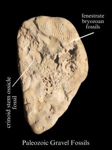 A Really Neat Fossil Find From Samantha Barnes Along The Pearl River.
Our State Survey geologist at MDEQ’s Office of Geology are fielding questions daily from the curious public about their rock and fossil finds from around the state. This intellectual curiosity about the natural world around us fuels important scientific discoveries and fosters conservation minded stewardship of our environment.
Earlier this week, the young fossil hunter Samantha Barnes brought to our scientist’s attention an interesting fossil that she had found while rock hunting along the Pearl River in Hinds County, Mississippi. Samantha quickly noticed the patterns and shapes in the rock she had picked up. She was certain she had discovered some kind of a fossil, maybe even more than one fossil embedded in the rock, and indeed she did!
Samantha was curious if the fossils could date back to the days of the dinosaurs. What she had discovered along the Pearl River that day was a collection of marine invertebrate fossils preserved in the rock from the Paleozoic era. The fossil were once the skeletons of ancient sea creatures that are way older than the days of the dinosaurs and came to rest on a tropical sea floor hundreds of millions of years ago.
Some of the fossils in the rock Samantha described to our scientists as a “scaly skin-like pattern in the rock”. These turned out to be the well-preserved impressions of an extinct colony of animals called fenestrate bryozoan. These lace-like animals would have been somewhat similar in appearance to a modern fan coral.
The other fossils she noticed in the rock were small cylindrical-shaped fossils that were identified as crinoid stem ossicles. Crinoids are called “sea lilies” but are actually not plants, but unusual animals related to starfish, brittle stars, and sea urchins. There skeletons are made up of numerous mineralized elements called ossicles that tend to disarticulate after the animal dies. Crinoids are living fossils that have persisted in the worlds oceans for hundreds of millions of years. They still inhabit unique environments in the oceans today.
Spectacular gravel fossil finds like Samantha’s are often people’s first introduction to the science of Paleontology in Mississippi. To help facilitate this widespread interest for people of all ages, MDEQ has published an educational resource for fossil hunters like Samantha called “Rocks and Fossils Found in Mississippi Gravel”. It is available for free download: Rocks And Fossils Found In Mississippi’s Gravel Deposits – MDEQ
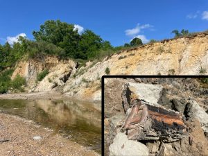 Stream Alluvium – Mississippi’s Treasure Chest of Paleontological History.
Stream alluvium is an important geologic unit that can be mapped all over the state. The tapestry of dendritic stream systems coalesces across the landscape to form larger rivers as they drain their way towards the Gulf of Mexico. The alluvium of a stream is the assortment of sand, silts, muds, gravels, and clay material deposited by the movement of water in the stream as carries the sediment along its valley that was eroded from the adjacent uplands within its water shed.
This stream sediment, collectively called alluvium, is an important environmental resource for a multitude of reasons: streams and their bottomland alluvial plains provide a rich and essential habitat for wildlife and botanical ecosystems. The fertile floodplain soils are the staple for agriculture in Mississippi. Groundwater found in alluvium comprises the largest and most environmentally sensitive shallow aquifer system in the state.
Did you know it is also one the most important paleontological resources we have in Mississippi? Streams carry with them and quickly bury the remains of animals, plants, and even human artifacts. These fossils are often deposited during major flooding events where they become locked away from time and the elements perfectly preserved in the wet sediments. These time capsules are later revealed again by the same stream process that once buried them as the constantly migrates slowly back and forth across its flood plain, eroding its banks.
Stream alluvium in Mississippi can be quite ancient and can date back as far the Pleistocene. Most of the ice age vertebrate fossils found in Mississippi, along with most of the Native American artifacts from various cultural time periods are found along streams. These fossils and artifacts found eroding from the alluvium date back many thousands of years or even many centuries. The floodplains of streams also host the largest concentration of archaeological sites than any other geomorphological features in the state. Though they are more prone to the effects of natural disasters, the resources provided by life on the floodplains are rich and unmatched from any upland environment.
Stream alluvium can also incorporate and concentrate large amounts of fossils from much older deposits. These fossils dating back millions of years are eroded from the underlying bedrock by the force of water running through the stream’s channel.
In the photo, you’ll see an outcrop of Pleistocene age stream alluvium from an outcrop being studied in the bluffs of Yazoo County by MDEQ’s Office of Geology research staff in the Surface Geology Division of the State Survey. Also, photographed is an ancient fossil log from the last ice age that eroded from this outcrop. It is nearly perfectly preserved, even after many thousands of years. Mastodon bones and other extinct Pleistocene animal remains were found at this outcrop on previous visits to study this stream alluvium fossil site.
These botanical remains are an important window into the ancient past. We are actively collecting these plant fossils and working with other scientists to study what the habitat along these streams was like during the last ice age. These Pleistocene plant fossils reveal a bottomland hardwood environment that would be more familiar in much more northern climates than that of the Gulf Coastal Plain of today.
 The Drew McGahey Clovis
Humans entered the paleontological record in Mississippi at some point during the last ice age. The Native Americans that first arrived, in what we know as Mississippi, encountered an environment that would seem quite strange to us today. The plants of the forests, the bottomlands, and even prairies would be more familiar in modern northern climates than to those of Mississippi today. The landscape hosted an even stranger variety of animals that are now long extinct.
Geology is the basis for the environment and is an integral part of archaeology. Geologic mapping is essential to understanding the age of landscapes, their paleoenvironment, and the distribution of natural resources available to their inhabitants. It is also important for characterizing depositional environments and the geochemistries that are conducive to the preservation of these important archaeological resources.
The stone tools, called lithics in archaeology, that these Pleistocene inhabitants left behind are often the only evidence that we have of their presence here in Mississippi. Because of this, the analysis of lithic is typically the only window we have to study and learn about these first peoples’ relationship with that ancient environment.
The ice-age first people’s cultures are known by their tool styles or traditions and are collectively referred to by the scientists who study them as Paleoindian. They were thought to be highly specialized nomadic hunters, of the now extinct megafauna of late Pleistocene, as evidenced by their exquisitely made stone tools and the scarce number of longer-term occupation sites that they left behind.
The discoveries of most of the known early Paleoindian artifacts in North America are quite happen-chance. They are often stumbled upon by landowners, collectors, and rock hobbyists; and very rarely by professional researchers in the field. This makes the general public, those who have found and collected these artifacts, typically the primary resource for information we, as scientists, have to study this earliest human time period here in Mississippi’s cultural prehistory.
Earlier this year, a Clovis point was found in a creek by a young man and brought to the attention of our Surface Geology staff. Clovis are the earliest recognized human artifacts found in Mississippi. This important discovery was made by Drew McGahey in northwest Copiah County.
This was a special find for several reasons. Drew is the grandson of the late State Archaeologist, Sam McGahey, whose work while at MDAH helped set the foundation for Paleoindian research in Mississippi. MDEQ, staff geologists worked with Sam over many years conducting and publishing research on the state’s geoarcheology. Drew’s find was also exciting as it is relevant to our recently published work and detailed geologic mapping that our Geology research staff have conducted in that area.
Drew’s Clovis artifact can reveal some very important clues about the ice-age people who lived in the area and their utilization of the resources in their environment. The Drew McGahey Clovis was found is a gravel-choked creek bed rich with excellent quality stone resources derived from the Pre-loess Terraces beneath loess in the uplands of the area. These gravel creek beds would have been mined for their exquisite quality chert, large gravel cobbles, and other important types of high-quality stone resources. It not uncommon to find artifacts that are evidence of the procurement of these resources such as tested cobbles and hammerstones amongst the gravel of in the creeks of the western loess bluffs.
The flood plains of these creeks would have once been home to an abundance ice-age wild game such mastodon, bear, horses, sloth, and tapir. But the ice-age hunter would have to across the rugged terrain of loess hills to venture out of these narrow creek bottoms to explore neighboring drainages. Fossil bones and teeth of these ice age animals are also commonly found along these drainages.
The Drew McGahey Clovis demonstrates a clear familiarity with working the locally-available gravel resources of Pre-loess Terrace Deposits by adopting the Clovis tradition and knapping methodology to the inherent properties of gravel resource.
Because of the geology and the geochemistry of the loess soils in the area the Drew McGahey Clovis was found, the potential for the preservation of early sites with things other than stone artifacts is possible. The find of this point outside of that type of context is still very important as it shows that people were indeed living nearby and utilizing the resources of the area. This also leaves open the potential that we may yet, one day, find an intact archeological site dating to the ice age in this type of environment with excellent preservation.
As other early artifacts, like the Drew McGahey Clovis, come to light and the potential for discoveries of intact archaeological sites, becomes more evident; a more complete, and likely more complex picture will emerge about the life ways of Mississippi’s first inhabitants during the last ice age.
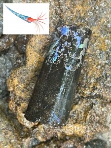
Our State Survey geologists at MDEQ are actively involved in working collaboratively with geological surveys of neighboring states, the National Park Service, and other agencies. This essential Survey research is encouraged through the state and by research grants funded by USGS and the NPS.
This week we feature a steinkern (internal cast) of the shell of the terminal Cretaceous Baculitid ammonite fossils from the Owl Creek Formation. This fossil was found in Union County last month near the K/Pg extinction boundary while conducting field research with the paleontology program at the Mississippi Museum of Natural Science.
Ammonites are an extinct group of shelled cephalopods, a diverse groups of predatory mollusks that are relatives of modern octopus and squid. For over 300 million years of our earth’s history the worlds oceans were teeming with a wide diversity of ammonites.
These cephalopod shell fossils are very important to mapping geologists and paleontologists in the field. They are excellent time boundary indicators because of their rapid rate of evolution and world-wide distribution in the marine sedimentary record.
Ammonites and their cousins, the nautiloids, lived together until the extinction event that killed off the dinosaurs, along with 75% of all life on earth, at the end of the Cretaceous period. This was when most all of Mississippi, and much of the coastal plain of our state and our neighboring states was covered in a shallow tropical sea.
Nautiloids inexplicably survived the extinction event at the end of the Cretaceous while ammonites did not and in doing so they flourished in the recovering ecosystems of the oceans. Today, the Nautilus is the sole living shelled cephalopod swimming the world’s oceans.
Different depositional environments and their fossil assemblages, called “facies” by geologists, are recorded across the coastal plain of the Northern Gulf of Mexico.
Because of this, open marine to shallow marine deposits of the late Cretaceous can be best studied in the central part of Northeast Mississippi, while the shallower marine to terrestrial facies from the same time period can be best studied further north approaching the Tennessee line.
Mississippi is known by many scientists to have some of the best preserved fossils in the world, going all the way back to the last days of the dinosaurs. Our featured fossil ammonite still retains some of its original mother-of-pearl from late Cretaceous period 66 Million years ago. This is because many of our fossils are not actually fossilized (mineralized) which preserves exquisite and rare details about the fossil not seen anywhere else. This means that they are actually still composed (all or in part) of their original organic materials, even though they can be many millions of years old.
Fossil like these and other things like shells, bone, teeth, and even wood that have not been altered by mineralization are extremely important to our scientists. They hold important detailed information about things like the life, diet, and even the environment of a long extinct species of plant or animal. This kind of biological data is completely lost in deposits that contain mineral-replaced fossils.
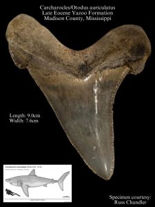
Before sea levels dropped and the Petrified Forest came into existence, much of Mississippi was covered in a deep ocean. In fact, during this time called the late Eocene (some 40 million years ago), the entire world saw much higher sea levels than that of today. Some of the same marine fossils found in the Yazoo Clay of Mississippi can also be found in the limestones that make up the pyramids of ancient Egypt.
During the late Eocene, the world had been in a greenhouse environment continuously since the days of the dinosaurs. Fossils of true giants can be found preserved in the Yazoo Formation such as the skeletons of toothed whales, the Basilosaurs, which where the largest creatures on earth at the time. They swam the Jackson Sea which is now Madison County with other large marine vertebrate such as a giant swordfish called Xiphiorhynchus.
But arguably, nothing at this time was more formidable in the oceans than the megatoothed shark, Carcharocles/Otodus auriculatus. This monster of a shark was one of the largest of its kind that ever existed. It’s teeth alone, though rather rare fossil finds in Mississippi, are a testament to just how awesome these creatures truly were. Their serrated teeth can reach up to almost five inches in length and over four inches wide. It is estimated that these shark could reach lengths of 30 feet or more and weighed up to eight tons.
This features an amazing find of a perfectly-preserved and truly giant example of a Madison County megatoothed shark from Charcharocles/Otodus auriculatus. It was discovered and collect by Russ Chandler from an outcrop the Yazoo Formation near Flora. Russ quickly brought his find to the attention of our MDEQ, State Geological Survey geologists for identification and documentation. Documenting this amazing find will be a great contribution in helping our scientists better understand our state’s rich natural history.
At the close of the Eocene, sea levels dropped and temperatures cooled causing the Basilosaurs to die out. This left these megatoothed sharks with no real competition from other sizable predators in the worlds oceans. Over geologic time their ancestors grew to even grander sizes, culminating in largest shark to ever live, Carcharocles/Otodus megalodon. C./O. megalodon thrived during the early Miocene and Pliocene epochs before further environmental changes in the ocean temperatures wiped them out some 3.6 million years ago.
 This fossil called Rhyncholampas goulgi was collected last month by MDEQ’s Office of Geology staff while leading a paleontological field trip in Smith County. The educational exercise was conducted in coordination with the Mississippi Museum of Natural Science for their summer Naturalist Camp. During this portion of the camp, students were introduced to the environmental science of geology and Mississippi’s rich natural history through paleontology and stratigraphy.
R. gouldi is small cassiuloid echinoid (about the size of a walnut) that once inhabited the warm shallow waters of the Gulf of Mexico during the earlier Oligocene (Rupelian), some 30 million years ago. This specimen was found in the Mint Springs member of the Vicksburg Group, which was deposited in a near shore environment. R. gouldi was a bottom feeder and was covered in a fine layer of short, bristle-like spines that it used for both protection and locomotion along the sea floor.
The limestones deposited in this area during that time are known as the Vicksburg Group, because they were first described by scientists from prominent outcrops along the Mississippi River in the vicinity of Vicksburg. Also, the deposits and the ocean here at that time are referred to as forming in the Vicksburg Sea. The fossiliferous limestones of the Vicksburg group form a narrow set of aggressive hills just south of the Jackson Prairie from Vicksburg through Byram, Brandon, and southeast through Waynesboro.
 This post features the release of the Gulf Islands National Seashore Paleontological Resource Inventory (Public Version) Natural Resource Report NPS/GUIS/NRR-2023/2525 by the Department of the Interior.
This is the fourth recent National Park Service publication acknowledging the help of MDEQ’s Office of Geology geologists. These recent reports include a Geology Report, on the Paleontological Resource Inventory of Vicksburg National Military Park (Public Version) was also released last month. with the acknowledgment that: “This report would not have been possible without the invaluable assistance of the Mississippi Department of Environmental Quality (MDEQ) Geologists”
Recently, our State Survey geologists at MDEQ have been working with and publishing paleontology research with the Geologic Survey of Alabama geologists, and paleontologists with the McWane Science Center and University of Louisiana, Monroe on the occurrence of Pliocene Graham Ferry fossil shark teeth and otoliths showing up on the beaches of Dolphin Island.
The Geologic Map of Jackson County (with portions of Harrison, George, and Stone counties), published in MDEQ Office of Geology as Open File Report OF-285 was used by the NPS authors and was instrumental in revising the geology from an earlier 2016 report by the NPS of the Gulf Islands National Seashore. Instead of recognizing the “Citronelle Formation” onshore and under the islands of the Gulf Islands National Seashore, individual coastal terraces are now recognized overlying the Pliocene Graham Ferry Formation, which is also an aquifer for coastal counties in Mississippi and Alabama. This foundational geologic work, Open File Report OF-285 was made in cooperation with the Office of Land and Water Resources with authors Lindsey Stewart and James Starnes.
This geologic mapping is not only being issued as the context for understanding the paleontology and geologic history of the Gulf Islands National Seashore National Park, it is being used to update out state’s stratigraphic nomenclature and as the basis for updating contiguous mapping by the geological surveys of Louisiana, Alabama, and Florida.
NPS’s Gulf Islands report: Click here.
Geological Map of Jackson County
For more information on the geology of Jackson County: OF-285 Surface Geology of Jackson County, Mississippi – MDEQ
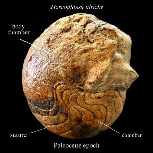 Our State Survey geologists at MDEQ are actively involved in working collaboratively with geological surveys of neighboring states. This research is encouraged through research grants funded by the USGS.
This week we feature a steinkern (internal cast) of the shell of the nautiloid, Hercoglossa ulrichi from the Paleocene of Alabama, measuring approximately 14 cm. In diameter.
Nautiloids are shelled cephalopods, a diverse groups of predatory mollusks that are relatives of modern octopus and squid. For over 300 million years of our earth’s history the worlds oceans were teeming with nautiloids along with their cousins the ammonites.
Cephalopod shell fossils are very important to mapping geologists and paleontologists in the field. They are excellent time boundary indicators because of their rapid rate of evolution and world-wide distribution in the marine sedimentary record.
Ammonites and nautiloids lived together until the extinction event that killed off the dinosaurs, along with 75% of all life on earth, at the end of the Cretaceous period. This was when most all of Mississippi, and the much of the coastal plain of our neighboring states was covered in a shallow tropical sea.
Nautiloids inexplicably survived the extinction event at the end of the Cretaceous while ammonites did not and in doing so they flourished in the recovering ecosystems of the oceans. Today, the Nautilus is the sole living shelled cephalopod swimming the world’s oceans.
Different depositional environments and their fossil assemblages, called “facies” by geologists, are recorded across the coastal plain of the Northern Gulf of Mexico.
Because of this, open marine to shallow marine deposits of the Paleocene can be best studied in neighboring Alabama, while the shallow marine to terrestrial facies from the same time period can be best studied right here in Mississippi.
For more on Mississippi’s geologic past:
Windows Into Mississippi’s Geological Past – MDEQ
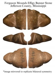
As the State Geological Survey, our MDEQ Office of Geology’s geologists often work with a number of experts in a wide variety of fields as it relates to our state’s fascinating geology and its history.
This month our Surface Geology team has been working on a project to help describe and document an important ancient Native American artifact from Ferguson Mounds in Jefferson County, Mississippi.
This artifact was collected around 1900 by Dr. M. W. Dickeson and was featured on page 201 in our early Geological Survey report from 1926, titled: The Archaeology of Mississippi, by Calvin S. Brown. This landmark publication by our Survey helped to highlight the importance of preservation and documentation of our State’s extensive prehistoric history and ancient cultural resources. The zoomorphic effigy specimen was originally described as the broken half of an artifact called a banner-stone styled into a “frog like” form. There is much debate in the archaeological community on the exact function of banner-stones. Many are made from exquisite and exotic stone sources, but very uncommonly are they in the form of effigies and even rarer do they take on a zoomorphic form like this one.
The artifact now resides professionally curated in the collections at the Gilcrease Museum in Tulsa, Oklahoma but made its way to back Mississippi on temporary loan to the State to be studied by a team of scientists, including our Office of Geology staff.
Our Surface Geology division staff described the effigy as manufactured from is stone called siderite. It is an earthy iron carbonate mineral that forms in a variety of coastal plain environments in Mississippi. It is reddish-brown to almost black and forms as nodules of various shapes and sizes. It is typically much harder and denser than limonitic clay-stone, commonly used in other ancient Native American artifacts. Siderite can easily be polished and can exhibit a subconchoidal fracture when broken. Raw nodules of the stone can have a flaky weathering character if its surface but contains a more desirable competent harder core underneath.
Siderite nodules can be found in a number of the geologic settings in Mississippi. It is best known for its abundance in Mississippi River alluvial gravels. It can also be found in the muddy brackish water environments along the shores of Mississippi’s Gulf Coast and can be distinguished when diagnostic mollusk fossil impressions are present or have characteristic holes in them from pholad clam borings.
The specimen measures 44.5 mm tip of nose to break, 38.8 mm wide at break, and is 23.7 mm thick. The approximated hole diameter 12.4 mm.
New geologic detailed geologic mapping research has been published on the area by our Surface Geology division which aided in the understanding of the geologic setting of the site the artifact was recovered from along with the availability of natural stone resources to the area. The Ferguson Mounds site is situated atop a bluff consisting of loess-covered, nearly level, Pleistocene age first terrace of the Mississippi River. Gravel resources near the base of the terrace, containing an abundance of siderite, are exposed along the banks of Mississippi River from Jefferson County south through Natchez. Early geologic work refers to these exposures as the “Natchez Formation”.
From being able to study the stone material, in person, our geologists concluded that the raw material this bannerstone was crafted from is indeed derived from a Mississippi River gravel sourced siderite. It was likely acquired along the river in gravel exposures outcropping nearby the Ferguson Mounds site.
Research biologist from MDWFP’s Mississippi Museum of Natural Science were also included in the scientific team to help to describe the zoomorphic effigy banner-stone. Thought we will never really know what the artist had in mind, it seems to be similar to the form of a salamander than that of a frog as originally described in Calvin Brown’s Archaeology of Mississippi report.
The diagnostic features of the blunt snout, large dorsal orbital sockets (though the eyes themselves are comparatively small), head profile, slender crouching front legs, and unexposed gill slits beneath the jowls are not similar of a that of or frog as the artifact was originally described. It could be imagined salamanders were possibly quite mysterious to the artist’s world. A number of beautiful and interesting types salamanders are native to Mississippi and locally to the Jefferson County area.
In fact, one of the largest salamander’s in North America inhabits the rocky environments of the Tishomingo County area. This true giant of a salamander is in the family Cryptobranchidae, known commonly of as the Hellbender. These large salamander would have been more commonly encountered by other Native American groups farther away but their dragon-like appearance may have added to the collective lore of these mysterious creatures in the artist’s world.
More on Calvin S. Brown’s, Archaeology of Mississippi: Archeology of Mississippi – MDEQ
More on recent geological mapping in Jefferson County and the Ferguson Mounds: OF-334 Geologic Map of the Pine Ridge Quadrangle Adams and Jefferson Counties, Mississippi – MDEQ
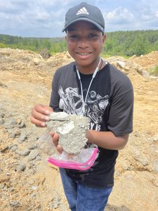
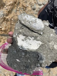 Geology is the basis for the environment and a broad exposure to the natural world around us is an essential aspect of environmental education. It takes a deeper understanding of the different factors and interrelationships that affect our natural world to fully comprehend and appreciate its complexity. MDEQ’s Office of Geology Staff works with the MDWFP’s Mississippi Museum of Natural Science to help foster public awareness and stewardship of our natural resources to preserve these natural environments and to help make them sustainable for future generations.
This past week MDEQ’s Office of Geology Staff lead a fossil collecting field trip for the Natural Science Museum’s Summer High School Naturalist Field Camp. We brought the participants to Smith County to a fossiliferous limestone outcrop, dating back some 30 million years to what once was the bottom of the Gulf of Mexico. Here we studied in great detail the various depositional environments of the ancient sea floor and the remains of the animals that once inhabited them.
Featured in today’s Fossil Friday is inspiring paleontologist and Museum summer naturalist camper, Christian Ingram proudly displaying his discovery of a fossil of an articulated pelecypod shell of the genus Penopea. This excellently-preserved fossil mollusk is an ancient relative of the modern geoduck, found today on the Atlantic coast and harvested as a food source. Christian and the other campers were given a great lesson on the various coastal depositional environments and opportunity to collect fossils of the different types of ancient animals that once inhabited them.
After the initial fossil excursion through central Mississippi, the summer camp continued down to the modern Mississippi Gulf Coast to participate in a host of hands-on active research with various coastal scientists in different fields and environments. We hope that these experiences help to inspire the next generation of environmental scientists such as geologists, biologists, and paleontologists for the future preservation of Mississippi’s natural world.
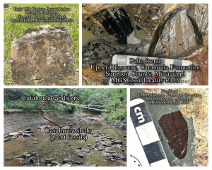 Geology is the study of the earth and archaeology is the study of the remains of the human record on the planet. Having an understanding of both helps us to better document the natural world around us, its natural history, and the history of the human interaction with it.
This week in the field brought me back to an outcrop of the Catahoula Formation in Simpson County to photograph and take some measurements. MDEQ’s mapping geologists had discovered this very important upper Oligocene in age fossil locality while conducting routine geologic mapping about 15 years ago and registered the paleontological site as Mississippi Geological Survey Fossil Locality #155 for future research.
In the few short years leading up to the COVID pandemic, our geologists had put together a paleobotanical research team to study the entire Neogene in the coastal plain of the northern Gulf of Mexico. This team included a star lineup of researchers from our State Geological Survey, University of South Alabama, Smithsonian Institution, Delta State University, and the University of Southern Mississippi.
Shortly after our first major paper on the Hattiesburg Formation (https://palaeo-electronica.org/content/2019/2540-miocene-plants-of-mississippi), we tragically lost our macroflora (fossil leaf expert) Dr. Brian Axsmith during the first round of COVID. Our paleobotany research continued strong, but only focused on the Palynology (fossil pollen and spores).
Our team is once again in full force with Dr. Debra Stults picking up the research where Brian had left us. So our work this week brought us back to visit this site, our team had planned to work on next.
This fossil site geologically predates the Hattiesburg site we had published on. It is composed of a thick fossil leaf-rich shale layer protected from erosion and natural weathering by a hard ledge of Catahoula sandstone.
On a high hill immediately above the fossil site is a small historic cemetery dating back to the early 1800’s. The cemetery site is pretty early for the area and remarkably still well-maintained by the locals, which included a small flag recently placed on a Civil War veteran’s grave. Being curious geologists. we were also particularly interested in the type of stone usage/diversity/timing of the grave markers while visiting the fossil site.
Not surprisingly, the oldest grave markers in the cemetery were made from the local Catahoula sandstone, very likely acquired directly from the fossil site in the creek below. We could imagine that the fossil leaves may have also been noticed by these earlier visitors and may have been curious about them, too while salvaging the flagstones of sandstone from the creek.
The succession of gravestone from Catahoula sandstone was followed by imported marble in the later 1800’s, and then concrete leading into the Depression era, and ultimately by finely polished granite in the mid-20th century.
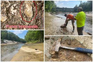 In the study of geology, a “Type Locality” of a geologic formation is the outcrop that it was first formally described and named by geologists. A formations Type Locality is often named for a nearby feature or landmark, typically the name of a creek or stream the outcrop is exposed in or even something like a close by town. The formation’s Type Locality outcrop is extremely important to geologist. The sediments, fossils, structures, depositional environment, and the stratigraphic position studied at a formation’s Type Locality are compared to other outcrops at the surface and in bore holes that penetrate similar strata in the subsurface. This information allows a geologist to properly correlate and accurately map the extent of geologic formation both at the surface and in the subsurface. When mapping the geology encountered in a region it is important to continually revisit and study formation’s Type Localities to gain this basic comparative scientific information.
Geology is the basis for the environment and that is why MDEQ’s Office of Geology, as the state’s geological survey, is charged with mapping the geology of the state. This information is essential for our state to properly understand, better conserve and protect, and manage its natural and economic resources. This includes mineral and groundwater resources, natural habitats, geohazards, and for land management (which includes private and municipal planning and development).
This week our mapping geologists revisited the Type Locality of the Byram Formation for ongoing detailed 7.5 min geologic mapping projects where other outcrops of the Byram formation are expected to be present and encountered. The Byram Formation is a fossiliferous marl (sandy fossil rich limestone) that was deposited in a shallow marine environment during a time known as the early Oligocene epoch, some 30 million years ago. The Byram Formation was named from an outcrop along the Pearl River underneath the historic Byram Swinging Bridge near the town of Byram in southern Hinds County, Mississippi.
The Byram Formation is the uppermost member of the Vicksburg Group that has been documented from Warren County across south central Mississippi, through Wayne County into south Alabama, and into the deeper subsurface throughout south Mississippi. It represents marine sediments from the last time the seas extended this far into Mississippi.
Today’s Fossil Friday features the fossil rich and scientifically important Type Locality of the Byram Formation. Photographed is the beautiful indurated marl exposures along the Pearl River at Byram, MDEQ geologist studying the outcrop, and a perfectly preserved fossil marine scallop shell (named Pecten byramensis) exposed at the outcrop. This field experience will prove invaluable to our scientists during the geologic mapping projects being conducted in central Mississippi over the coming months.
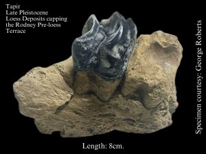 Fossils are essential for geologists to understanding past environments. These paleontological resources are how we piece together the details about the landscape and plants and the animals that once inhabited it.
As we discussed in last week’s Fossil Friday, MDEQ’s geologic mapping program (State Survey) has been studying a broad, flat, loess-covered terrace that stretches across western Jefferson County and south through Natchez, overlooking the Mississippi River. This terrace was left behind by the Mississippi River near the height of the last glacial maxima. As ice accumulated on the continent to the north, sea levels dropped dramatically causing the great river to cut a deeper valley and abandon its previous floodplain level, leaving the terrace behind. This drop in the river’s base level is was the creation of the Mississippi Delta Region as we know it today, bordered by the highlands of the bluffs.
Glacial flour from off of the newly-formed alluvial plain blew in as dust storms quickly capped the terrace upland in thick deposits of loess. This silt formed as ground rock from a mile-thick sheet of ice bulldozed and scraped the bedrock to the north. Loess soil is rich in minerals and well-drained. The basis for a lush ice-age habitat, safe from the episodic flooding of the river valley below.
The loess is also rich in calcium carbonate minerals making it ideal for excellent fossil preservation of the ice age animals that inhabited the region. We know from their fossils that extinct giants like the American lion, mastodon, mammoth, and giant ground sloths were common place here and that the first human inhabitants to Mississippi likely encountered and even hunted them and maybe even were hunted by them.
A particularly curious pig-like animal, the tapir, also called this loess-covered terrace environment its home. These large herbivores had a short snout that was prehensile like that of an elephant’s trunk. They were certainly numerous base on their relative abundance in the fossil record. Tapir still exist today in the woodland jungles of Central and South America but became extinct here in North America sometime towards the end of the last ice age around 11 to 12,000 years ago.
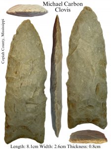 Humans entered the paleontological record in Mississippi at some point during the last ice age. The Native Americans that first arrived in Mississippi encountered an environment that would seem quite strange to us today. The plants of the forests and prairies would be more familiar in modern northern climates than to those of Mississippi today. The landscape hosted an even stranger variety of animals that are now long extinct.
Geology is the basis for the environment and is an integral part of archaeology. Geologic mapping is essential to understanding the age of landscapes and their paleoenvironment. It is also important for characterizing depositional environments and the geochemistries conducive to the preservation of these important archaeological resources. The tools that the first inhabitants left behind in Mississippi are the only evidence we have to study and learn about these first peoples’ relationship with that ancient environment.
The ice-age first people’s cultures are known collectively by the scientists who study them as Paleoindian. They were thought to be highly specialized and nomadic hunters of the late Pleistocene as evidenced by their exquisitely made tools and the scarce number of longer-term occupation sites that they left behind. The discoveries of most known early Paleoindian artifacts are happen-chance and made by landowners, collectors, and hobbyists, and not often by researchers in the field. This makes the general public, those who have found and collected these artifacts, the most important resource for information we, as scientists, have to study this earliest human time period in Mississippi’s prehistory.
Earlier this year, a Clovis point was found and brought to the attention of our Surface Geology staff. Clovis are the earliest recognized human artifacts found in Mississippi. This important discovery was made by Michael Carbon in his cultivated food plot overlooking the upper reaches of the Homochitto River in southwest Copiah County.
This excited our MDEQ, staff geologists because of their recently published research and detailed geologic mapping work they have conducted in the area. Michael’s Clovis artifact can reveal some very important clues about the ice-age people who lived in the area and their utilization of the resources in their environment.
Not too far to the west of where Michael’s Clovis was found, a broad flat loess covered terrace stretches across western Jefferson County and south through Natchez, overlooking the Mississippi River. Thanks to the work of our fossil collector friend, George Roberts, this expansive loess plain is also known to have once been home to an abundance ice-age wild game such mastodon, bear, horses, sloth, and tapir. But the ice-age hunter would have to venture east into rugged loess hills, away from this fertile plain for the essential stone resources for tool making.
The Michael Carbon Clovis demonstrates a familiarity of the important gravel resources in the Pre-loess Terrace Deposits found in the uplands of this loess terrain and the exquisite stone resources which they provide.
The Clovis artifact definitely originated from the loess bluffs area but was not actually found in either of these important resource-rich loess environments. It was found further to the east, just outside of the loess terrain.
The Michael Carbon Clovis was found along of the uppermost reaches of the Homochitto River in the southwest corner of Copiah County. An environment quite geologically and ecologically different than the loess region. Today it is a pine forest ecology with poor acidic soils. The geology of this region consists of cuesta capped with red sand and poor-quality gravel resources of the Pliocene age Brookhaven Terrace. Headwaters of streams in this area form from multiple springs as they emerge from the eroded perimeter of this gravelly terrain and expose the sandstone and clay of the underlying Miocene bedrock.
Because of the geology, the soils of the archaeological site the Michael Carbon Clovis was found on lend to very poor preservation of anything other than stone. We may never know exactly what resources this environment along upper reaches of the Homochitto provided that these first Mississippians were utilizing. But by being able to identify the rock source area it was manufactured from, we do know that the point moved along with these first inhabitants between these two very distinctly different ecological regions. As other artifacts may come to light from this archaeological site over time, a more complete, and likely more complex picture will emerge about the lives of our State’s first inhabitants during the last ice age.
More on the geology of the area that helped to tell this story:
OF-295 Geologic Map of the Rodney Quadrangle Jefferson and Claiborne Counties, Mississippi – MDEQ
OF-299 Geologic Map of the Union Church Quadrangle Jefferson County, Mississippi – MDEQ
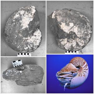 For over 300 million years of our earth’s history the worlds oceans were teeming with shelled cephalopods, called ammonites and nautiloids. These diverse groups of predatory mollusks are relatives of modern octopus and squid. They swam and hunted in both shallow marine waters and the open seas. Species of these strange creatures ranged in size from fractions of an inch to true sea monsters with shells larger than 8 feet and diameter and likely weighing more than a thousand pounds.
Today ammonite and nautiloid shell fossils are highly-prized by collectors. These iconic fossils have distinctive radiating patters (called) sutures that range from simple in nautiloids, to amazingly complex fractal patterns in ammonites. Their shells were constructed of beautiful mother-of-pearl. This fossil shell material is also prized today as an iridescent gemstone, called “ammolite”.
Ammonite and Nautiloid shell fossils are very important to mapping geologists and paleontologists in the field. They are excellent time boundary indicators because of their rapid rate of evolution and world-wide distribution in marine sedimentary record.
Ammonites and nautiloids lived together until the extinction event that killed off the dinosaurs at the end of the Cretaceous period. Mississippi was covered in a shallow sea at that time. Therefore, we can best study this time period right here in outcrops in what is now northeast Mississippi. Fossil finds of these shelled cephalopods are quite common across much of the Black Prairie and Pontotoc Ridge regions of the state along with a wealth of other fossil remains.
Todays Fossil Friday features a large specimen of the fossil nautiloid, Eutrephoceras. It was collected by MDEQ Office of Geology staff from an outcrop of the Late Cretaceous Ripley Formation in Union County, near Blue Springs Mississippi. Large dinosaur bones and ammonite fossils were also found at this site where this nautiloid was collected.
At the end of the Cretaceous period a meteorite struck the Gulf of Mexico, killing 75% of all life on earth. This included all of the non-avian dinosaurs on land and all of the ammonites in the worlds oceans. Nautiloids however, did survive this catastrophe, specifically Eutrephoceras. Because of this, the Nautilus is the sole shelled cephalopod swimming in the world’s oceans today.
Click here for more on Mississippi’s Late Cretaceous Geology.
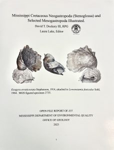 This is important addition to our scientific study of Mississippi’s natural history and research on the Late Cretaceous Period of North America. This volume has numerous detailed color photographs of the beautifully and amazingly well-preserved fossil mollusk shells. During the days of the Dinosaurs northeast Mississippi was once covered by a tropical shallow sea and these fossils represent part of that ancient ecosystem.
Some of the specimens figured for this project now reside in the collections of our national museum, the Smithsonian. The Mississippi Geological Survey has continued this important work since it’s founding in 1850 as Mississippi is home to some of the most significant paleontological resources on the planet. Hard copies are available through our publications and map sales. To find out more about our MDEQ, Survey Library’s online publications follow the link below.
To Download a free digital copy, click here.
To order a hard copy for $20, click here.
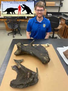 Pleistocene fossil remains from the giants of the last ice of extinct beasts such as mammoths, American lion, giant bison, mastodon, saber toothed cats, horses, giant ground sloths, tapir, gomphothere, pampather, and dire wolves that once hunted and grazed along the prairies of what is now northeast Mississippi. Surface Geology staff joined the paleontologists from Mississippi Museum of Natural Science and the MCWain Science Center in identifying a new fossil find this week. The amazing find of associated bones of the bear-sized giant ground sloth made, Megalonyx jeffersonii, was made earlier this week by USFWS biologist, Dr, Luke Pearson while conducting a freshwater mussel survey with his team in Noxubee County, Mississippi. The enormous bones consisted of well-preserved portions of the pelvis, an almost a complete ilium and part of the ischium. MMNS paleontologists George Phillips identified the animal as an extinct ground sloth, MCWain Paleontologist Jun Ebersol further described it as the remains of very large male, MDEQ geologist James Starnes ascertained that the skeleton was found in situ and likely right where the sloth’s carcass came to rest and was deposited in the stream which will warrant further investigation by scientists of the fossil site. Dr. Pearson (pictured with his find) has donated the specimen to the museum where it can be further curated for future studies.
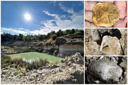 MDEQ Office of Geology staff have been visiting a geological and paleontological playground in Smith County, Mississippi for years. The Smith County Lime Pit has been a useful window into the Lower Oligocene Series and specifically the Vicksburg Group. The Lower Oligocene encompassed a time period from 34 million years before present to 28 million years before present. The formations that are present for this time period in the strata at the Smith County Lime Pit are the Forest Hill, Mint Spring, Marianna Limestone, Glendon Limestone, and the Bucatunna. These formations represent one of the last great sea level rises in Earth’s history. The Forest Hill represents a deltaic environment that was followed by the Mint Spring, Marianna, and Glendon when a shallow tropical sea covered this area. The Buccatunna occurs last in this sequence representing the fall in sea level and a deltaic environment once again.
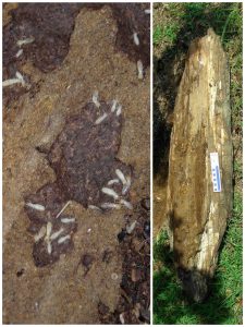 Our geologists working jointly with the Mississippi Museum of Natural Science in the field near Aberdeen, MS encountered something truly strange back in June of 2007. A 90 million year old, partially petrified (silicified) log from the late Cretaceous period Tuscaloosa Formation being feasted on by living termites!
HOW COULD THIS EVEN BE POSSIBLE?!
One of the most common questions our MDEQ, State Geological Survey geologists get asked is “how long does it take for something to fossilize?” This is a really great question, but the answer isn’t that simple but always surprises folks. It is also quite nuanced and takes a bit of explaining to really understand.
First of all, fossils are the remains of plants and animals preserved in the geologic record. “Fossilization” typically refers to the mineral replacement of things like bone, teeth, shells, or wood by turning them to stone. Fossils and fossilization (mineralization) aren’t at all necessarily the same thing. Mineralization of a fossil or “fossilization” occurs through geochemical processes that are not dependent on a particular amount of time, but more specifically dependent on the environment.
Mississippi is known by many scientists to have some of the best preserved fossils in the world, going all the way back to the last days of the dinosaurs, like our fossil wood featured in today’s FossilFriday from late Cretaceous period. This is because many of our fossils are not actually fossilized (mineralized) which preserves exquisite and rare details about the fossil not seen anywhere else. This means that they are actually still composed (all or in part) of their original organic materials, even though they can be many millions of years old.
Fossil shells, bone, teeth, and even wood that have not been altered by mineralization are extremely important to our scientists. They hold important detailed information about things like the life, diet, and even the environment of a long extinct species of plant or animal. This kind of biological data is completely lost in mineral-replaced fossils.
This termite-infested fossil log from the days of the dinosaurs is a great example of understanding fossils and fossilization. Due to the chemistry of the geologic setting of this fossil log, some parts of it underwent mineralization that replaced it with silica minerals, while other parts remained perfectly preserved. The original wood being enjoyed like a well-aged fine wine by the termites that encountered it. This is just another amazing observation encountered by the work of our scientists in the field. (Photos courtesy George Phillips, MMNS).
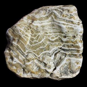 Gravel fossil hunting is a state-wide pastime in Mississippi enjoyed by people of all ages. Whether it’s a young child sorting through the gravel for geologic treasures on the playground at recess or the curiosity of an adult picking up a rock that caught their eye out in their driveway, it is often the first introduction to paleontology for most folks here.
Our chert gravel deposits in Mississippi eroded from ancient limestone bedrock sources north of here, up in the mid-continent, and were brought down and deposited by rivers as they once crossed the coastal plain on their way to drain into the Gulf of Mexico.
Patterns of Mississippi’s chert gravel were created by the abundant fossils remains of ancient Paleozoic era sea creatures (hundreds of millions of years old) and continue to spark the curiosity of our local rock and fossil hunters and folks of all ages today.
For our geologists these gravel fossils are an important tool for studying the geologic history of these gravel and the shifting bedrock areas of these ancient drainages that brought the gravels down here over time.
Featured today in this Devonian Stromatoporoid fossil from the gravels of the ancestral Mississippi River Pre-loess Terrace Deposits in Warren County, Mississippi collected during field work with the University of Mississippi earlier this month. This particular specimen demonstrates the exceptional detail that can be preserved in these ancient fossils in our gravel.
Stromatoporoids were reef-forming sponges from the Devonian period (some 400 million years ago). They are found here exclusively among the gravels of ancestral Mississippi River Pre-loess Terrace Deposits, beneath the loess along the western bluff line overlooking the Mississippi River Delta region, from Memphis to south of Natchez. Their natural presence and abundance in these Pre-loess Terrace gravels helps to mark a geologic shift in drainages of the exposed bedrock sources in the upper reaches of the Ohio River Valley region during glaciation of the mid-Pleistocene some 700,000 years ago.
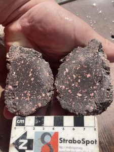 Geology Staff collected gravel samples in Warren County with the University of Mississippi geology doctoral student Maxwell Pizarro. Max’s primary focus of study is on igneous rocks.
Mississippi is a coastal plain state and all of our geology at the surface is sedimentary in origin. Therefore igneous rocks only occur at the surface here in sedimentary environments, such as a constituent of our gravel deposits.
Only two geological deposits contain igneous gravel rocks. One is the modern Mississippi River alluvium that underlies the Yazoo Basin in the Mississippi Delta region. The other is in the gravels of the ancestral Mississippi River Pre-loess Terrace Deposits which lie perched high above the delta along its eastern valley wall, beneath the thick loess deposits in the Loess Bluff Region.
Max worked with us earlier this week (over his spring break) in sampling our diverse collection of volcanic rocks from the Pleistocene gravels of the Pre-loess Terrace Deposits in western Mississippi. These rocks included extrusive rocks called rhyolite, trachyte, and volcanic tuff.
This week he also went to the field with our geologists to study and sample outcrops of the Pre-loess Terrace gravels in Warren County. His study for this project will be to help describe and source these volcanic rocks to their bedrock origins, some of which are over a billion years in age.
This valuable information will help our scientists mapping the geology of the area understand the dynamics of the evolution of Mississippi River in the lower valley over the course of its glacial history during the Pleistocene.
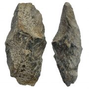 While conducting field studies for geologic mapping, our MDEQ, survey geologists often find evidence that we are not the first people to visit these, often remote, outcrops. Pictured below is a prehistoric Native American artifact, a crude biface (approximately 18cm in length) that was observed while studying a geologic outcrop in Yazoo County, Mississippi. It exhibits heavy use-wear from preferential battering along one edge. This artifact was fashioned from silicified fossil palm (Palmoxylon), from the Early Oligocene, Forest Hill Formation. Fossil Palm was prized by the early Native American inhabitants for it unique texture and beauty.
30 Million year old fossil pollen and spores samples were taken recently from a lignite bed at this outcrop for palynology study and paleoenvironmental reconstruction of these ancient deposits. This same geologic layer also bears large-diameter root bulbs of these fossil palm stumps, and the artifact was presumably a product of reduction of these silicified stumps for lithic material procurement, representing the evidence of an ancient mining practice. Stone tool artifacts made from fossil palm are well-documented from nearby prehistoric sites along the Yazoo River and likely originated from this and other nearby outposts.
A poster on this paleobotanical research on the plant fossils we collected from the Forest Hill Formation was given recently at both the Botanical Society of America and last month at the Mississippi Academy of Sciences on the details of our findings. This work was authored by a collaboration between Delta State University, the Smithsonian Institution, and MDEQ, geologists with the State Geological Survey.
A detailed geologic map, including the aspects of the paleontology and geoarcheology of the area is due to be published by our office this July through a cooperative mapping grant with the United States Geological Survey’s StateMap program.
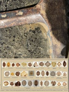 What was it like millions of years ago? We can study the fossil bones, teeth, and shells of long extinct animals, but how do scientists know what rest of the details to make a picture of what the world they once lived in, so long ago, looked like? Our researchers at MDEQ’s Office of Geology frame that picture with the multifaceted research involved in what they do in geologic mapping projects. Geology not only provides information about our natural resources and provides the foundation for the environment that currently inhabits it, studying it also is our window into the environments of the deep past. This week MDEQ’s Surface Geology mapping staff field checked outcrops of the Forest Hill Formation for newly-drafted geologic maps soon to be published on Cox Ferry area of Yazoo County, Mississippi. The Forest Hill Formation consists of alternating sands and clays from formed in a coastal delta some 30 Million Years Ago. It us sandwiched between the deep marine clays of the Yazoo Formation below and the shallow tropical Vicksburg Limestone above. Further to the south (down-dip), these same are buried deeply by younger geologic formations, There, these sands act as an important fresh groundwater aquifer for the citizens of state and these outcrops we are mapping serve as the aquifer recharge areas for this essential natural groundwater resource. Along the bedding planes, photographed at one of these ancient outcrops off of Cox Ferry Road, a hash of lignitized fossil plant remains was studied this week by our field staff. We know from previous studies that fossil palm (Palmoxylon) dominates the silicified wood found here that once made up the forests along the riparian environments bordering the ancient river delta, but our research team has been learning much more. Office of Geology staff has been collaborating with paleobotanists and palynologists from Delta State University and The Smithsonian Institute to study and photograph the wealth of exquisitely-preserved fossil pollen spores to gain a more complete picture of the plant diversity and the paleoenvironment of the Forest Hill Formation.
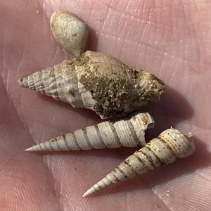
If you look very carefully along the nature trail behind the Mississippi Museum of Natural Science, as you descend in elevation from the bluff to the Pearl River swamp, you will begin to notice that there are sea shells everywhere. These are not modern shells brought in with the gravel for the trail but fossils eroding from the bluff. They are from an ancient sea bed from a time long ago called the Eocene Epoch, almost 40 million years ago. The reason this bed of sea shells (called the Moody Branch Formation) are pushed up and exposed there has to do with a much more ancient story, from a much more ancient time. Buried much deeper beneath the Museum is the apex of a large volcanic structure, dating to the days of the dinosaurs during in the Cretaceous period, some 75 million years ago. This was once part of a string of volcanic islands (much like the Hawaiian islands today) that stretched from Jackson, through the Mississippi Delta, and into Arkansas. Please do not collect the shells, because this scientifically important outcrop is part of a Mississippi State Park. Just know their story, appreciate the local geologic history, and please share it with others.
This week, MDEQ Office of Geology research staff conducted a brief field study with museum’s Paleontology program’s George Phillips, Dr. Ezat Heydari faculty of the Earth Sciences program at Jackson State University, and were accompanied by high school student intern Nolan Wells who was job-shadowing with us this week. Featured photo of the week are a collection of perfectly preserved fossil mollusk shells of two specimens of Turritella alveata (Conrad in Wailes, 1854), Lapparia dumosa exiqua Palmer, 1937, and Carycorbula densata (Conrad in Wailes, 1854).
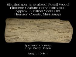 Mississippi has been well recognized by scientists throughout the world and by our own residents as having a wealth of geological resources, especially when it comes to our fossils. Fossils can tell us a great deal about the age and past environment of rock units in Mississippi, so much in fact, they are essential to interpreting our state’s geology.
While fossils from ancient marine environments are often the subject of detailed studies in Mississippi, those from terrestrial environments are just as equally plentiful but still poorly documented and understood. Marine fossils are dominated by the remains invertebrate a vertebrate animals while terrestrial environments chiefly consist of remains of fossil plants.
MDEQ’s Office of Geology’s ongoing collaboration with paleobotanists at Delta State University, University of Southern Mississippi, University of South Alabama, and The Smithsonian Institution are starting to open up a world of new knowledge of our past terrestrial environments with detailed studies of fossil plant sites in Mississippi. These studies have traditionally focused on fossil pollen and leaf fossil studies, but fossil wood in particular have received less research attention.
Fossil wood can be found throughout the state from the Paleozoic times (before the days of the dinosaurs) to the Pleistocene (the last Ice Age). Though much of it may look similar, it isn’t remotely the same stuff. Each formation it occurs in represents a different time period with a different ecology and different species of fossil plants, including trees. The study on fossil wood is very difficult and it is only done by a handful of very specialized scientists. Because of the wealth of fossil wood in Mississippi, we are beginning to reach out and work more with these specialists to open up a world of understanding to what the trees and forest were like throughout geologic time in Mississippi.
The photo features features an exquisitely preserved piece of silicified wood collected on a canoe trip from the Wolf River in Harrison County by Rep. Manly Barton, Mississippi House of Representatives District 109. It is likely derived from the Pliocene age outcrops of the Graham Ferry Formation which outcrop along the stream. This fossil wood is from a tree that grew in an ancient river delta, some 5 million years ago. The forests in this environment existed just before the onset of the Ice Ages of the Pleistocene.
The preservation of this fossil wood specimen is so detailed it is termed “permineralization”, a scientific term meaning that individual structures of the plant including things like the cell-wall can still be observed.
 Some 20,000 years ago during the height of the last glacial maxima in the latter part of the Pleistocene ice age, the Mississippi River drained an ice-gripped landscape far to the north down through what is now Mississippi. Summers brought dark muddy floodwaters down the ancestral Mississippi River as the ice fronts melted back slightly, to then return to a dusty dry floodplain landscape as the next winter and ice returned. High winter winds created large dust storms across the Mississippi River valley and deposited glacial silt along the uplands in Mississippi from Memphis to Natchez and as far east as Hinds County in Mississippi. This silt was ground from the bedrock up north by the flow of ice. This created what is known as the Loess Bluff Region overlooking the Mississippi Delta Region today. The thick mineral-rich loess soils supported a lush temperate ecosystem of grassy plains along older river terraces uplands and hardwoods along stream bottomlands that dissected the region. Megafauna such mammoth, mastodon, giant ground sloths, saber toothed cats, tapir, giant bison, horses, and American lion roamed the area. While more discretely in the grass and forest leaf litter millions of pulmonate gastropods (land snails) thrived along the ground in this thriving ice age environment. Their fossil shell remains are the most abundant and best preserved of any ice-age fossil found in Mississippi. Theses snail shells are around 20,000 years old and perfectly preserved in the loess as if they were deposited yesterday. This specimen was photographed in Natchez last month by Office of Geology staff conducting field geologic mapping for the National Park Service.
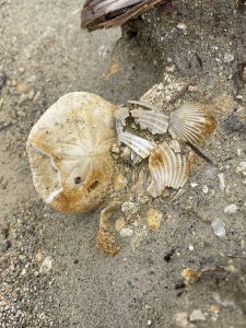 Smith County’s geology is crossed by narrow narrow band of limestone hills containing the fossil remains of shallow sea. The band of limestone of the geologic formation called the Vicksburg Group, stretches east from Vicksburg, crosses HWY 18 in Smith County near the Jasper County line, on through Waynesboro, Mississippi.
It is a 30 million year old, extremely fossiliferous geological feature that contains the remains of an entire shallow marine ecosystem that once inhabited what is now central Mississippi from a time called the Early Oligocene epoch.
The limestones are rich with the remains of mostly fossil invertebrates such as mollusks, bryozoans, echinoids, crabs, and foraminifera. It also hosts an amazing variety of vertebrate fossils such as sea turtles, excellently preserved fish, sirenians, rays and sharks…lots of shark teeth!
The Vicksburg Limestone host a great diversity of sharks fossils, both of large and small species. In fact, fossil teeth from Carcharocles auriculatus, one of the largest sharks to ever inhabit the earth have been discovered at these rock outcrops in Smith County.
Featured this week is an excellently preserved fossil echinoid (relative of a sand dollar) named Clypeaster rogersi, from the Mint Springs member of the Vicksburg Limestone. It is surrounded by abundant fossil seashells of the scallop named Pecten byramensis. It was photographed during joint fieldwork being conducted by Office of Geology Staff and other researchers.
Field studies help our scientists understand and familiarize themselves with the geology of the state and study how it related to the stratigraphy and geological history, the environment, mineral and groundwater resources, and to natural and wildlife ecosystems.
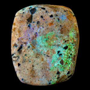 Mississippi’s unique geology is endowed with extremely rich fossil deposits. Many of these treasures adorn local personal collections and professional collections in museums across the globe. Though the interest in Mississippi’s geology by collectors and scientists is mainly in these excellently-preserved fossil specimens, our State’s gravels have been regularly combed since ancient times for beautiful stones such as agates, carnelian, jasper, clear quartz, and petrified wood. A Mississippi tradition that today is still held by many rock-collecting enthusiasts. But until recently, no known precious gemstones have ever been discovered in Mississippi.
About a hundred years ago in neighboring Louisiana, a small-scale deposit of gem-quality opal was mined. This occurred in the Flemming Formation of Vernon Parish along the Texas border where a small deposit of vibrantly colored matrix was discovered cementing sandstone into hard quartzite. This opal was once sold directly to Tiffany’s Inc. in New York City and fashioned into gemstones.
Field mapping by the Mississippi Geological Survey in Claiborne County in 2004, has led to the discovery of another precious opal deposit in the South. This time from the Catahoula Formation of Mississippi. This rare occurrence is even more spectacular than the one found in Louisiana.
The research leading to this amazing discovery was conducted under a cooperative geologic mapping grant between the United States Geological Survey and the State. The raw stone material was initially tested for gem quality by the Mississippi Gem and Mineral Society’s expertly skilled craftsmen. The exquisitely-crafted stones show beautifully brilliant flashes of opal fire, ranging in color from green to red.
The discovery of this site is very sensitive, not only for the precious gem-quality opal it contains, but also because of the signs of pre-historic Native American activity associated with the outcrop. This includes opalescent quartzite artifacts! A number of other quartzite-bearing outcrops have been discovered mapping in south Mississippi. Therefore, it is entirely possible that other outcrops may also contain gem-quality Mississippi Opal.
Cauliflower chert geodes, also commonly referred to as “Keokuk geodes”, can commonly be collected from our Pre-loess Terrace gravels and from gravel bars along the Mississippi River. They are typically lined with quartz crystal druse or botryoidal chalcedony, while some examples grew solid and lack a geode cavity. They originated from Paleozoic bedrock limestones in the upper-reaches of the Mississippi River and its tributaries and were carried down here to Mississippi as a constituent of gravel. Many of these cauliflower chert geodes once originated as ancient fossils, such as calyxes crinoid, that became the nucleus for silica mineral growth from fluids within the limestone. The fossil became badly distorted by the growth of chalcedony and remained hollow inside until mineral-rich waters deposited quartz growth along the walls of the badly distorted fossil. The resulting cauliflower chert eroded from the bedrock limestone, leaving pits along its surface where the remaining fossil piece dissolved out. Figured in stages, is this geologic process of cauliflower chert formation recorded in crinoid calyx examples collected from Paleozoic bedrock, along with two cauliflower chert geodes from the Pre-loess Terrace gravels from Mississippi. The last two examples were photographed from Mississippi gravel. The first (stage 4 photo) was collected from Yazoo County and latter, in-situ on the banks of the Mississippi River by MDEQ, Office of Geology staff in Natchez. Special thanks to Rebecca Thea Davis for providing the bedrock fossil examples from Tennessee.
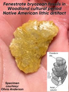 Our chert gravel deposits in Mississippi eroded from ancient limestone bedrock sources north of here, up in the mid-continent, and were brought down and deposited by rivers as they crossed the coastal plain on their way to the Gulf of Mexico.
Patterns of Mississippi’s chert gravel were created by the abundant fossils remains of ancient Paleozoic era sea creatures (hundreds of millions of years old) and spark the curiosity of our local rock and fossil hunters and folks of all ages today. This undoubtedly has also been the case for people here more than 13,000 thousand years.
Towards the end of the last ice-age, the indigenous population of Mississippi first utilized these abundant fossil-bearing chert gravels as a primary resources for tool manufacturing. On literally a daily basis, over the course of thousands of years, these first people’s cultures encountered these patterns created by these fossils preserved in the stone that a familiarity with these gravel fossils surpasses any of today.
Figured in this post is a good example of this in an artifact called a flake, a sharp spall created during a lithic tooth manufacturing technique called flint-knapping. It was collected from a Woodland cultural period site (500BC-1000AD) in a plowed agricultural field by Olivia Anderson in Yazoo County. This example is littered with well-preserved fenestrate bryozoan fossils that were identified in the artifact by Office of Geology staff.
Bryozoans are colonial animals similar to corals but are unrelated. Fenestrate bryozoans can easily be identified by their delicate lace-like structures. These ancient Bryozoans first appeared in the fossil record during the Carboniferous and went extinct during the Permian period (345-268 million years ago). They are one of the most common fossil occurrences amongst our chert gravels.
So what were the stories and traditions about these fossil that the person that made this artifact had? Undoubtedly, this person had an intimate knowledge and an encyclopedic cultural understanding of these gravel resources, as did generation after generation before them in making literally millions of tools from these native geologic resources.
More on our gravel fossils:
Rocks And Fossils Found In Mississippi’s Gravel Deposits – MDEQ
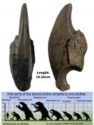 Towards the end of the last ice age, the area that is now the Mississippi’s Loess Bluff region was a strange place some 20,000+ years ago. Frequent dust storms in the Yazoo Basin brought massive amounts of glacial silt off the Mississippi River floodplain. It came down the river from glacial meltwater floods, blown off the surface once dry, and deposited into the adjacent eastern uplands. These thick loess soils are very rich in minerals and nutrients and were quickly vegetated in the moister climate of the bluffs. Several species of giant ground sloths once inhabited this area and thrived eating the lush vegetation in the loess bluffs. They were true gentle-giants. Their fossil bones, such as this exceptionally well-preserved claw found by last month by William Pettis in Yazoo County and identified by Office of Geology staff, are a testament to this lost world from the ice-age in Mississippi’s Loess Bluff region.
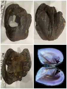 Specimens of siderite (an iron carbonate mineral) are among the most common rocks brought in off the Mississippi River for identification. They are unusually heavy for their size and range in color from black to red-orange and typically exhibit very shiny polish on the surface of the stone. They are often mistaken for a variety of things such as meteorites, fossil bones and teeth, and even dinosaur skin impressions due to their wide range of unusual shapes, sizes, and textures. Siderite forms naturally from the geochemistry of the groundwater of the Mississippi River’s alluvium. This mineral can indeed replace (mineralize) organic materials such as fossil bone, wood, and apparently even mollusk shell by occupying tiny pore spaces of these organic materials. One particularly interesting specimen was brought into the Museum of the Mississippi Delta by Laura Sanford during a fossil road show in late October in Greenwood. It was identified by at the special program by Office of Geology staff as a rare occurrence of a Pleistocene age, siderite-replaced freshwater mussel shell from the alluvium of the Mississippi River. This unusual ice-age mollusk fossil was collected on the Louisiana side of the Mississippi River in East Carroll Parish. Geology staff identified it as Potamilus purpuratus, also commonly known as Bluefer or Purple-shell mussel, aptly named for its distinctive beautiful purple color mother-of-pearl of this species, which still inhabits many rivers in Mississippi and Louisiana today. The excellent presentation of this fossil freshwater mussel exhibits both valves of the shell still articulated (attached) in typical mussel death position (shell open).
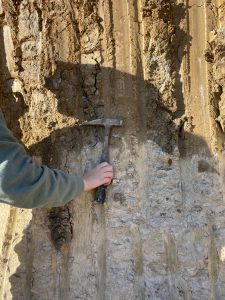 This week, just minutes after MDEQ’s Surface Geology staff Jonathan Leard successfully defended his masters thesis at Mississippi State University on the first detailed geologic map of the Starkville area, he was found studying an important and newly exposed geologic outcrop just off of campus. Here he explains to MSU freshman anthropology student, Abigail Starnes the important geologic contact that is represented in the fresh excavation. The lighter-colored rock unit below, is a limestone called the Prairie Bluff Formation. It from the Late Cretaceous period and is chock full of marine sea shell fossils that were some of the last things alive in the ocean just before the meteorite struck the earth that killed off the dinosaurs some 66 million years ago. The darker-colored deposits above the limestone are significantly younger and are from the late Pleistocene. It contains the fossilized remains of extinct ice-age land animals that the first people in North America and the first Native Americans to arrive here in Mississippi would have encountered. The contact between these two geologic units is called an unconformity because it represent missing time between the two formations. In this case, a hiatus of tens of millions of years, which can only demonstrated by studying the abundance of different fossils contained between the two geologic units at this outcrop.
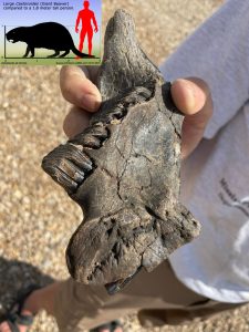
The current near historic low of the Mississippi River has it’s dry banks exposing miles of seemingly endless sandbars that are now, once again, sharing its ice-age secrets from the river’s depths. Pleistocene fossils from extinct beasts such as American lion, giant bison, mastodon, saber toothed cats, horses, giant ground sloths, tapir, gomphothere, pampather, and dire wolves that once hunted and grazed along the forests and wetlands of the Mississippi River floodplain have now been exposed along the now barren river bottoms. Surface Geology staff joined the Mississippi Museum of Natural Science and USFWS scientists this week along the banks of Mississippi River in Warren County to help understand and to better document these important paleontological resources during this unique environmental opportunity.
During this field trip an important discovery of a fossil of an ancient bear-sized rodent, a giant beaver called Castoroides ohioensis, was made by biologist Paul Hartfield during the trip. Paleoindian cultures, the first human inhabitants of Mississippi, likely shared their environment with this and other strange Mississippi ice-age beast.
Additionally, a larger ice-age Mississippi River bottomland ecosystem was documented during the study which included fossils of giant catfish, gar, turtles, alligators, giant bison, deer, elk, mastodon, mammoth, and horse. These fossil specimens will be accessioned into the Mississippi Museum of Natural Science paleontological collections for public display and for scientific study.
As the glacial climate ended and the environment rapidly changed along the Mississippi River at the close of the Pleistocene, the ice-age megafauna gradually became extinct. People persisted along the great river and they, along with the ecosystem began to adapt to a world that we are more familiar with today.
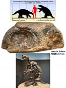 The first people, to inhabit the Mississippi’s Northwest Delta region towards the end of the last ice age lived in quite an unfamiliar world than that of today. It was once thought that this area, known today as the Yazoo Basin, was an environment called as “braided stream”, a formidably unstable landscape that would have been largely uninhabitable by these first people known as Paleoindian cultures.
This idea was only just recently dispelled by research that identified numerous Paleoindian archaeological sites and used it to date landforms within the Yazoo Basin. This important research was published on by a team of scientists from the Office of Geology and the L.B. Jones Trust. The L.B. Jones Trust is an important archaeological and paleontological collection housed at the Museum of the Mississippi Delta for the preservation of Mississippi Delta history and scientific research. View the Office of Geology publication here.
As glacial ice was making its final retreat into the arctic, these ice age Paleoindian hunters here in the lower Mississippi River valley encountered a bounty of wildlife along the meanders and back swamps of the great river. Familiar to these first people of the Delta were animals such as American lion, giant bison, mastodon, saber toothed cats, horses, giant ground sloths, and dire wolves that hunted and grazed along the forest and wetlands of the Mississippi River floodplain. As the climate rapidly changed at the close of the Pleistocene and the megafauna gradually became extinct, people in the Delta during the Early Archaic cultural period adapted to their surroundings.
Remains such as fossil bones and teeth of these extinct ice-age beasts that once inhabited the Delta can still be found along the gravel bars of the Mississippi River today. Featured in this week’s fossil Friday is the portion of a fossil jaw from bear-sized ground sloth, Paramylodon harlani, commonly known as Harlan’s ground sloth. It was collected in Washington County, Mississippi by L.B. Jones Trust chairman and researcher, Anna Reginelli and identified this week by Office of Geology Staff.
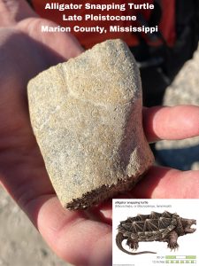 As geology is the basis for the environment, geology staff is often involved in multidisciplinary research with other agencies and institutions. Yesterday, Geology staff assisted the Mississippi Museum of Natural Science conservation biology team in a freshwater mollusk survey being conducted on the Pearl River in Marion County. During Thursday’s survey, State Ichthyologist, Robbie Ellwanger discovered a bone from a very large turtle amongst the gravel in the river. The bone was identified by geology staff in the field as an ice-age fossil turtle and the specimen was collected for study. Vertebrate fossils from this part of Mississippi are very rare and are essential to our understanding of the geologic history of the area. Once the team returned to the museum, Paleontologist George Phillips further identified the fossil bone as a piece of a large alligator snapping turtle shell. This find is a first for the area, making it an important contribution to the fossil record.
The alligator snapping turtle (Macrochelys temminckii) is the largest species of freshwater turtle in North America. Individuals of this icon reptile can live over 100 years and grow to be more than two hundred pounds. The family that includes these turtles goes back to the days of the dinosaurs during the Cretaceous period. Very little is known about alligator snapping turtles in the fossil record and most material available for study comes from ice age river and swamp sediments deposited during the Pleistocene. They are currently listed as a vulnerable species in need of conservation efforts. This important fossil specimen will be accessioned into the Mississippi Museum of Natural Sciences paleontological collections. There, it will help scientists to better understand the Pearl River’s ancient geologic past and will also help in studies of this living fossil in North America.
Mississippi’s wealth of well-preserved fossils have been studied by researchers from all over the world for more that two centuries. That tradition continues through to today as MDEQ,s geologist performs the work of Mississippi’s Geological Survey in studying the state’s natural resources and its natural history. The fossils contained in the various geologic deposits around the state hold important clues to past life, past climates, and past ecosystems. What our scientists learn has implications for not just here in Mississippi but also around the world. Fossils are important tools for geologists to help map geologic formations and to correlate rock units far beyond the boarders of the state. The scientific value of invertebrate fossils such as ancient marine mollusk shells are very important in this respect. Our State Geologist, Dr. David T. Dockery is an invertebrate paleontologist who’s research focuses specifically on studying, naming, and describing these important resources. Following recent publications on hid studies of fossil mollusks from the Late Cretaceous deposits of northeastern Mississippi, 27 holotypes of new fossil gastropod species were sent to the Smithsonian this month to be archived in the U. S. Natural History Museum’s collections.
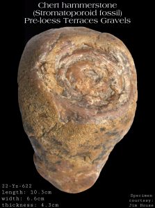 This Late Archaic cultural period Native American artifact, utilized as hammer-stone, was collected off a prehistoric archaeological site by an oxbow lake near Satartia in Yazoo County, Mississippi. It was utilized sometime between 2,000 BC and 800 BC from a large Stromatoporoid chert gravel fossil.
Stromatoporoids were reef-forming sponges from the Devonian period (some 400 million year old). They are found among the gravels of ancestral Mississippi River Pre-loess Terrace Deposits, beneath the loess along the western bluff line overlooking the Mississippi River Delta region, from Memphis to south of Natchez. Their natural presence and abundance in these Pre-loess Terrace gravels helps to mark a geologic shift in drainages of the exposed bedrock sources in the upper reaches of the Ohio River Valley region during glaciation of the mid-Pleistocene some 700,000 years ago.
They are curiously absent from our older (pre-glacial) Pliocene age High Terrace gravels further east in south-central Mississippi. The occurrence of these chert fossils in archaeological context at sites has been observed broadly across the MS Delta Region and also, as far east of the bluff-line as Smith County in Mississippi. This helps demonstrate a relatively long distance prehistoric cultural trade of these high-quality, larger chert clast-size gravel resources that emanated from the Mississippi loess bluffs region, east into areas with limited and poorer quality available resources.
Special thanks to Jim House of the Mississippi Archaeological Association, Madison Chapter for allowing MDEQ, Surface Geology staff to identify and photograph this remarkable fossil artifact specimen.
Linked below is the MDEQ FossilFriday post from September 6, 2019 featuring another interesting stromatoporoid fossil culturally utilized as an ancient artifact. It is polished mano artifact collected from an archaeological site along the Leaf River in Smith County, Mississippi. This was found roughly 100 miles east from its original natural source in the Loess Bluffs. The use-wear exhibited on the mirror-like, highly-polished surface of the artifact exposed incredibly detailed features of the fossil’s mamelon and astrorhiza structures.
Click here to learn more about the Smith County Stromatoporoid Artifact Specimen:
 The revelations garnered from our recent geological mapping work on the timing and evolution of the lower Mississippi River Valley, has lead to the development of a new framework to better understand the environmental effects of the cyclical glaciation on the lower Mississippi River valley and it’s geology. Our work has identified Pleistocene deposits containing a host of well-preserved flora, faunal, and even early cultural remains that have yet to be fully studied and relayed in their proper context.
Core samples were taken today during a drilling projects to study an uninterrupted stratigraphic section of an ancestral Mississippi River Pre-loess Terrace Deposits in Jefferson County, MS. This terrace is blanketed by more than 70 feet of loess cover, masking a perfectly-preserved paleosol and surfacial clay stratum from the alluvium of the ancestral Mississippi River during the last interglacial stage of the Pleistocene. This is just before the river abandoned this level and began cutting its present valley during the last glacial advance.
Radiometric dating of these core samples is planned and will necessarily benefit our stratigraphic understanding along. Palynological research for paleoenvironmental context will be done, as well.
Outcrops of this terrace have been described along the river in the early literature as the “Natchez Formation” but the extent and context of it has only been recently understood. We have mapped the extent of this level of Pre-loess Terrace from southern Claiborne to Adams County.
The expression of this loess-draped terrace surface is heavily dissected today by erosion. But during the last glacial episode, it hosted a lush broad and level prairie environment overlooking the Mississippi River and boarded to the east by the older aggressive uplands.
Thanks to the work of George Roberts, a host of well-preserved late Pleistocene Megafauna remains have been recovered from the drainages that dissect this feature along with artifact evidence of early habitation from Paleoindian and early archaic cultures. Undoubtedly this is just scratching the surface of what is preserved here.
Within the last few thousand years this feature has undergone erosion, but still was was considered ideal for habitation into the later cultural periods. Iconic archaeological sites such as Feltus Mounds, Anna Mounds, Windsor Mounds and Windsor Ruins are just a few of studied sites adorning the expression of this terrace surface. — with Paul Parrish and Jonathan Leard.
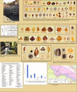 Geology is the basis for the environment and fossils are an important tool for our scientists that study Mississippi’s geology. These ancient clues provide us the necessary details to understand the age, depositional environments, and layered sequences that make up the geology of our state. Many people think of Mississippi’s fossils as the large ancient bones and numerous sea shells which can been found throughout the state. But many of the most important fossils we study can’t be seen with the naked eye. Billions of tiny skeletons of animals called foraminifera make up much of our state’s limestones and other marine deposits while tiny grains of fossil pollen and spores from ancient plants can be quite abundant and exceptionally well-preserved in many of our terrestrial deposits. Studying these sequences of alternating terrestrial and marine environments helps us to understand past climates and how it has changed over geologic time. While much work has been done on our marine fossils, comparatively little is known about these fossils from our terrestrial environments. Over the past decade, MDEQ’s Surface Geology and Mapping program has been collaborating with a number of universities and institutions to better understand these terrestrial environments and the fossil plants and animals they contain. This team includes researchers from Delta State University, The Smithsonian Intuition, University of South Alabama, Mississippi Museum of Natural Science, University of Southeastern Mississippi, and many others. Recent work has been focused on the plant fossil of the Lower Oligocene age Forest Hill Formation while sampling several outcrops during geologic mapping across the central part of the state. The contact between terrestrial Forest Hill Formation and underlying marine deposits of the Late Eocene age Yazoo Clay mark an important boundary in earth’s climate history, some 34 million years ago. The earth had been in a tropical greenhouse environment for tens of millions of years, going back to the days of the dinosaurs, and then suddenly began to cool at the close of the Eocene epoch. This climate shift is recorded in the fossils in both the Eocene and Oligocene age rocks of Mississippi and studying it is important to furthering our understanding of this time period. Preliminary research findings of the palynology (tiny fossil plant pollen and spores) from our sampling efforts of Forest Hill Formation were presented in a poster by our study’s lead author from Delta State University, Dr. Nina Riding last month at the Botanical Society of America’s conference in Anchorage Alaska. Surface Geology staff is proud to be a part of this research team. These collaboration efforts in various aspects paleontology continue to expand our understanding of Mississippi geologic past.
To learn more about Mississippi’s Geologic past here.
To learn more about Mississippi’s Cretaceous Geology here.
Do you have a rock or fossil that you want more information on? Click here to Ask a Geologist.
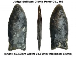
Humans entered the paleontological record in Mississippi at some point during the last ice age. The Native Americans that first arrived in Mississippi encountered an environment that would seem quite strange to us today. The plants of the forests and prairies would be more familiar to modern northern climates than to those of Mississippi today. The landscape hosted animals that are now long extinct such as mastodon, mammoth, giant beavers, ground sloths, horses, and giant bison. These animals were hunted by predators such as saber-toothed cats, dire wolves, and these first peoples. Lower sea levels exposed land far into the Gulf of Mexico miles beyond the barrier islands of today as evidenced by the Office of Geology Mapping in Jackson County, MS as well as an ice-age forest exposed by Hurricane Ivan in 2004, 60 feet beneath the Gulf of Mexico, south of Gulf Shores, AL.
Geology is the basis for the environment and an integral part of archaeology. Geologic mapping is essential to understanding the age of landscapes and their paleoenvironments, as well as characterizing depositional environments and the geochemistries conducive to the preservation of these important archaeological resources. The tools these first people left behind in Mississippi are the only evidence we have to study and learn about these first peoples’ relationship with their environment.
These ice-age cultures are known collectively as Paleoindian. They were thought to be highly specialized and nomadic hunters as evidenced by their exquisitely made tools and the scarce number of longer-term occupation sites that they left behind. The discoveries of most known early Paleoindian artifacts are by landowners, collectors, and hobbyists, and not made by researchers in the field. This makes the general public, those who have found and collected these artifacts, the most important resource for information scientists have to study this early time period in Mississippi’s prehistory.
On June 14, 2022, a very important discovery was made of an early Paleoindian point in Perry County, Mississippi by Matthew Sullivan, an artifact enthusiast and Circuit Court Judge for the 13th District of Mississippi while he was rock and artifact collecting with his friends. Realizing the significance of his find, Judge Sullivan brought it to the attention of the Surface Geology staff for examination. Retired archaeologist, Samuel Brookes consulted on the find during Judge Sullivan’s visit. The artifact was identified as a Clovis point making it approximately 13,000 years old. Geology staff identified the stone as a rare form of pure chalcedony not naturally occurring here in Mississippi.
Geology staff collected additional laboratory data on the point and consulted with geological surveys in nearby states to conclude the bedrock origins of the stone. The Judge Sullivan Clovis was manufactured from a type of pure chalcedony from agate replacement of fossilized coral. It is an extremely high-quality, translucent stone found only in Miocene and Pliocene age rock outcrops in Florida.
Geological resources naturally available to prehistoric cultures for stone tool manufacturing in the part of southeast Mississippi that The Judge Sullivan Clovis was found are scarce according to recent research published by Office of Geology staff. The discovery of The Judge Sullivan Clovis is important to science because it demonstrates the movement of people and material from east to west through south Mississippi during this ancient time in Mississippi’s ice age history.
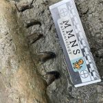
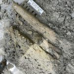
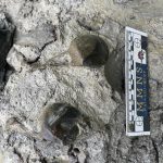

Mississippi has a rich geologic past with a fossil record that includes a history in the Mesozoic era, also better known as the days of the Dinosaurs. Outcrops from the Late Cretaceous period underly the rich soils of the Black Prairie and uplands of the Pontotoc Ridge physiographic regions of northeast Mississippi. Much of these deposits were formed in warm tropical shallow seas teaming with life and now rich with their fossil remains. While the dinosaurs walked on land, giant marine reptiles and sharks ruled these ancient seas. Fossil bones and teeth of these animals are commonly found along an abundance of ancient sea shells from mollusks in most outcrops of Cretaceous age in Mississippi. The currents, waves, and storms along with scavengers tend to widely scatter these remains. Therefore, actual fossil skeletons of these animals are important and rare finds. Last month, Surface Geology staff partnered with vertebrate paleontology staff at the Mississippi Museum of Natural Science, to excavate an intact skeleton of a sea dragon, called a Mosasaur. The recent discovery was made by museum staff conducting fieldwork near Westpoint, Mississippi. This species of Mosasaur, known as Clidastes propython, is approximately 80 million years old. Though typically only isolated bones and teeth are ever found, this is the most common mosasaur found between the geologic units of the Tombigbee Sand and the Arcola Limestone at the top of the Mooreville Chalk/Formation. This find was in the middle part of the Mooreville Formation above an important geological mapping marker that can be traced a long distance, a fossil bed made up entirely of the extinct oyster called Ostrea falcata. The team managed to excavate portions of the skull (with teeth still intact) along with a number of vertebrae and some rib bones. This important specimen will be carefully reconstructed and curated for future study. #fossilfriday
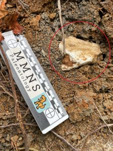 During the last ice age, the prairie regions of northeast Mississippi were an environment that was a paradise for a host now extinct Pleistocene mammals and other ice age megafauna. Gently rolling grasslands were once broken by streams with broad alluvial plains boarded by bottomland forests. Saber-toothed cats, American lions, giant ground sloths, mammoths, mastodon, giant bison, giant armadillo, giant elk, giant tortoises, and even herds of horses once roamed this rich dark soils region. Paleoindian cultures, such as Clovis were among the first human inhabitants to Mississippi, some 14,000+ years ago, and were certainly witness to these great animals of long ago and exploited the bounty of this Mississippi ice-age ecosystem. Fossil bones of many of these extinct animals are commonly found in stream alluvium of the Black Prairie region of northeast Mississippi. Pictured is a large unidentified ice-age fossil mammal bone exposed along an outcrop of Pleistocene age stream alluvium that was encountered by MDEQ, Surface Geology staff while conducting field work this week in Clay County with the Mississippi Museum of Natural Science while studying the underlying Cretaceous geology bedrock. The natural weathering of these chalky limestones over the course of tens of thousands of years form the dark rich soils for which is the basis for this prairie environment.
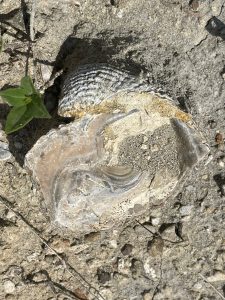 The last days of the dinosaurs ended some 66 million years ago when a giant meteorite impacted the Gulf of Mexico and created a world-wide extinction event which instantaneously changing Earth’s environment, climate, and devastated ecosystems. As the work of the State’s Survey, research is being conducted by MDEQ’s Office of Geology staff this week in the Starkville area to map and delineate geology representing this time. This will be used to better understand this important time in Earth’s history, both before and after this event, which is best recorded in our geologic record in northeast Mississippi. Featured here are Late Cretaceous marine fossils from the Prairie Buff Formation that are being studied by our scientists from outcrops in Starkville area. Fossils from this time not only include the infamous dinosaurs, but also important invertebrate fossils, part of a once thriving diverse tropical marine ecosystem. This is represented in the Prairie Buff Formation by an abundance of giant extinct fossil oysters, clams, and snails that once inhabited the sea floor of the during the Late Cretaceous, just moments before the extinction event. #fossilfriday
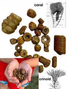 Gravel fossils are many Mississippi folk’s (especially children) first exposure to paleontology. These ancient tiny fossil treasures can commonly be found along gravel roads and driveways, along creeks and streams, even on school playgrounds throughout much of Mississippi. Seven year old Fen Anderson, a budding geologist from Yazoo County, recently shared his discoveries with MDEQ, Office of Geology scientists. These tiny ancient sea creature fossils are of solitary rugose corals and crinoid stems from Paleozoic era, making them older than the days of the dinosaurs. His awesome fossil collection pictured here came from just one day’s worth of searching through playground gravel at Manchester Daycare. #fossilfriday
For more on collecting rocks and fossils from Mississippi gravel, click here.
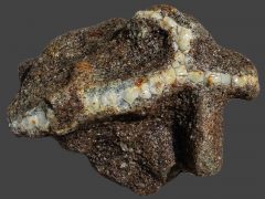 Ichnology is a discipline of Paleontology that is the scientific study of tracks and trace fossils. Knowing what kinds of animals occupy certain depositional environments, the traces and tracks they leave behind, and an understanding of geochemistry help us to translate ancient geologic outcrops. This beautiful example was collected in Lauderdale County by Leslie Potter and sent to Office of Geology staff this week for identification through our “Ask a Geologist” online public outreach program. These excellently-preserved fossil decapod burrows are part of the Lower Eocene age Tallahatta Formation. This ichnofossils is named Thalassinoides and were made by numerous marine burrowing shrimp that once occupied a tropical sandy shallow sea floor that once occupied the east-central Mississippi area some 50 million years ago. They are preserved as stone casts from being naturally cemented with silica minerals that have now become harder than the surrounding sandstone so that they weather in relief. Because the chemistry of the sediments didn’t preserve any other fossils of marine life that once certainly occupied the area, these ichnofossils prove important to helping us understand the ancient depositional environment of the sandstones of the Tallahatta Formation. Every so often some rare fossil sea shell impressions have been found there but are extremely rare, whereas these Thalassinoides burrows are quite abundant. This one in particular is a pretty special find. The gassy-fill substance in the burrow is called Tallahatta Agate. It is a natural mineral formation of nearly pure chalcedony and opaline silica. Thank you again Leslie Potter for sharing your discovery with our geology research staff and allowing us to share it with others.
Click here to learn more about Lauderdale County geology
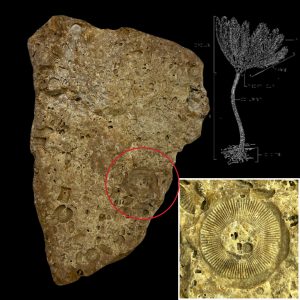 Ancient marine fossils, much older than the days of the dinosaurs can be found in chert gravels right here in Mississippi. This crinoidal chert (a type of rock that was once the sea floor dominated with the skeletal remains of fossil crinoids) from Jefferson County was photographed this week by Office of Geology staff. Complete fossils of crinoids are rarely preserved intact, though there individual segments and partial stems and calyx are some of the most common chert gravel fossil found in Mississippi. Crinoids are echinoderms, relatives of starfish and sand dollars and are still alive today in the worlds oceans. Paleozoic era chert gravel fossils from Mississippi can be found naturally though much of the state. They were once eroded from ancient limestone bedrock sources north of here, up in the mid-continent, and were brought down and deposited by by ancient rivers flowing to the Gulf of Mexico. Collecting gravel fossils are often the first exposure folks have to our rich paleontology resources in Mississippi. Crinoids are one of the many treasures to be found in our Mississippi chert gravels. Chert gravels is an important economic resource commonly used in many civil applications throughout Mississippi. So, gravel fossils can be found almost anywhere from playground, aggregate, to gravel roads and driveways, even in cement gravels along downtown sidewalks.
Click here for more information on Mississippi gravel fossils.
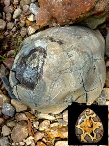 Calcite septarian nodules (commonly called dragon stones) are natural concretions of calcium carbonate that exhibit secondary mineral growth of yellow “dog-tooth” calcite along an intricate network of desiccation-like cracks. They make excellently beautiful mineral specimens, especially when they are carved, cut, and polished or as interesting curiosities if left natural. They typically form in impure, sandy, and fossil shell-rich limestones (called marls) from the geochemistry and movement of shallow groundwater. Groundwater moving through the marl formation derives carbonate minerals from dissolving and leaching from fossil sea-shells in the rock and concentrates it into a nodule. As the nodule solidifies to a hard rock it begins to shrink and a network of cracks form throughout the nodule. The voids created by the desiccation-like cracks then begin growing “dog-tooth” yellow calcite mineral precipitated from the carbonate-rich groundwater water. These nodules are much harder and more erosionally-resistant than the surrounding geologic formation they formed in. Therefore, they tend to weather in relief from the outcrop or completely weather out and can concentrate as unusually large bolder-gravels along stream beds that wind their way through the formation. Only a few geologic formations in Mississippi exhibit this phenomenon. Most notably is the early Eocene age Bashi Formation of east-central Mississippi in the vicinity of Meridian. Another example (photo below) of exceptional quality was recently documented by MDEQ, Office of Geology staff from the Late Eocene in age Moody’s Branch Formation while describing geologic outcrops in the field with in Yazoo County, Mississippi.
Click here for more on Mississippi’s Geologic past.
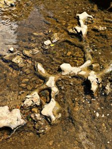 Ichnology, a discipline of Paleontology, is the scientific study of tracks and trace fossils. Knowing what kinds of animals occupy certain depositional environments, the traces and tracks they leave behind, and an understanding of geochemistry help us to translate ancient geologic outcrops. These excellently-preserved fossil decapod burrows where photographed in the field last week by MDEQ, Office of Geology staff. The fossil burrows were discovered eroding from an Eocene (Claiborne age) outcrop of the Creola Member of the upper Cockfield Formation exposed in the creek floor. They are preserved as stone casts from being naturally cemented with siderite, a distinctive iron carbonate mineral. Siderite commonly forms in shallow marine, brackish water, near-shore environments. With these clues found in the outcrop in the floor of the creek along with numerous seashell fossils it contains, it’s not hard to imagine a place very much like the Mississippi Sound today…shallow muddy water filled with burrowing crab and shrimp, as well as snails, oysters, and clams while drum fish, sea trout and flounder tail along the grassy shallows…but this is almost 40 million years ago, in a world filled with much more stranger beasts…and in Yazoo County, Mississippi. #fossilfriday