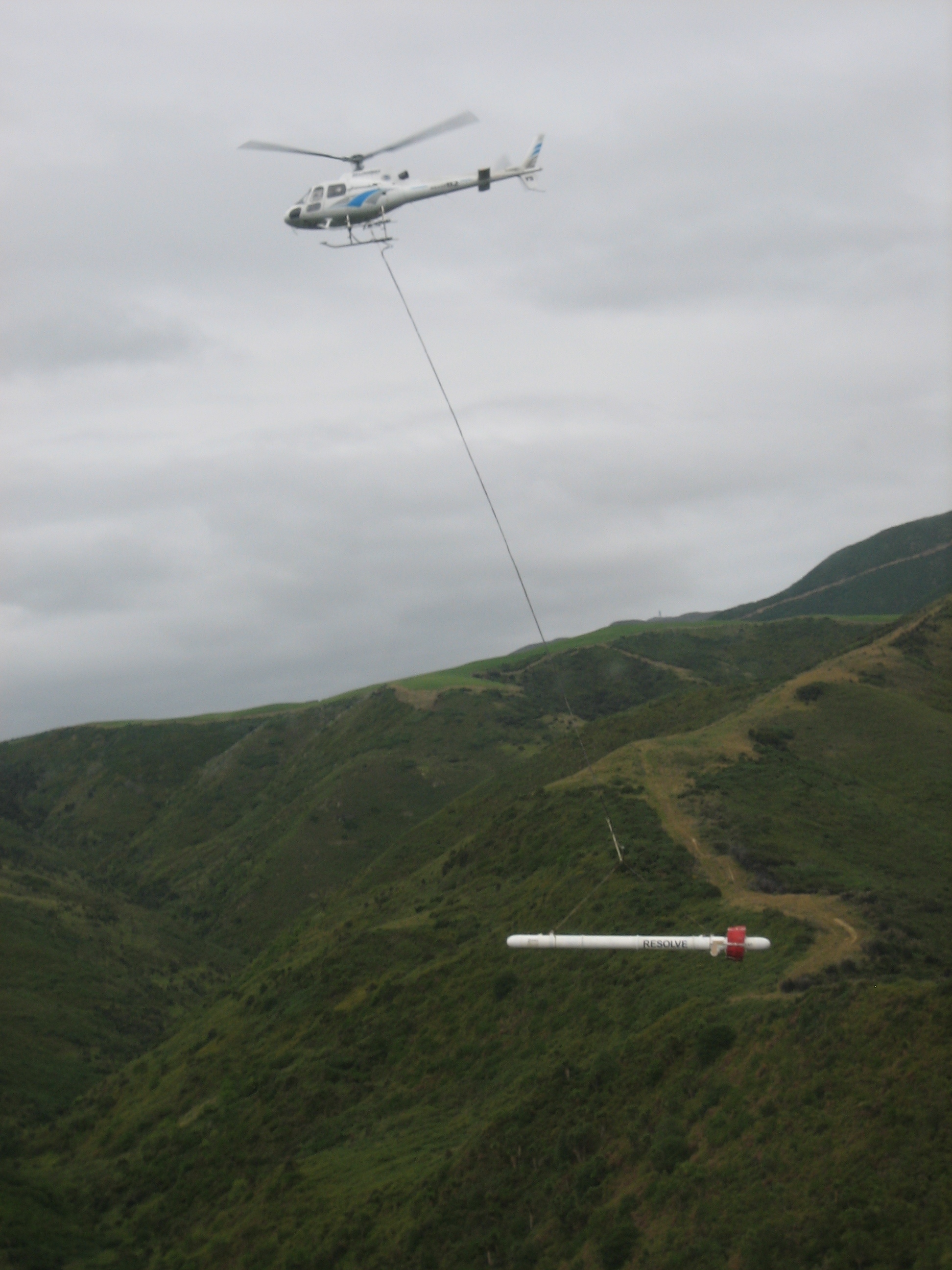
USGS to Collect Data Using Helicopter in Mississippi Delta
(JACKSON, Miss.) — Starting in late February and running through early March 2018, the United States Geological Survey (USGS) will use a specialized instrument towed beneath a low-flying helicopter to collect data about the Mississippi River Valley Alluvial Aquifer in an area just north of Greenwood. The instrument is contained in a 30-foot long torpedo-shaped tube that will be suspended 100 feet below the helicopter, which will fly at an altitude of 200 feet. The data collected will allow scientists to better understand the properties of geologic layers beneath the land surface. Details of this data collection project are explained further in the attached USGS fact sheet. Additional information can be found at the following website: https://www2.usgs.gov/water/lowermississippigulf/map/geophysics.html.
The shallow alluvial aquifer supplies most of the water for irrigation, aquaculture, and wildlife habitat enhancement in the Delta. Water levels in this aquifer have declined as demand has increased since the 1980s. The Delta Sustainable Water Resources Task Force, led by the Mississippi Department of Environmental Quality (MDEQ), was formed in 2011 to develop strategies to assure that the Delta will have adequate agricultural water resources for the future.
The helicopter-based survey beginning this month north of Greenwood is the first phase of an airborne geophysical survey of the entire Mississippi Alluvial Plain, which includes portions of Mississippi, Arkansas, Louisiana, Tennessee, and Missouri. Data gathered will be used to improve the USGS regional water availability computer model, which will assist state and local water management agencies like MDEQ and the Yazoo-Mississippi Delta Joint Water Management District (YMD) in making decisions regarding the region’s water supply. The Agricultural Research Service (ARS) has received funding for a groundwater-to-groundwater transfer pilot project to be constructed by the Vicksburg District of the U.S. Army Corps of Engineers (USACE) in the Shellmound area later this year. This project is one of several alternatives the Task Force is investigating that could potentially contribute to reducing declines in the aquifer. The helicopter-based survey data will be useful in the design of this pilot project.
In 2017, the USGS, working with ARS, YMD, and MDEQ, installed groundwater monitoring wells and collected data at the Bush farm near Money. The data collected in that project will also be used in the design of the groundwater-to-groundwater pilot project. John Bush said, “In collecting and analyzing the data on our farm, the USGS team was easy to work with and careful not to disturb our operations. I am confident that this helicopter-based data collection will go smoothly, and I am convinced that the work is important to the future of agriculture in the Delta.”
Kay Whittington, Director of MDEQ’s Office of Land and Water Resources, said: “We are very fortunate that this work is beginning in Mississippi. The data collected will help us better understand the alluvial aquifer. Accurate information is critical for the evaluation of alternatives to provide sustainable water resources for irrigation, aquaculture, and wildlife enhancement.”
The Task Force consists of Delta Council, Delta F.A.R.M., MDEQ, Mississippi Farm Bureau Federation, the Mississippi Soil and Water Conservation Commission, the Natural Resources Conservation Service, USACE, and YMD. The USGS, the Mississippi State University Delta Research and Extension Center, and ARS have coordinated with the Task Force on studies and projects.
The equipment that will be used for the helicopter-based data collection will be available for viewing at 2:00 p.m. on Tuesday, February 20, at Provine Helicopter Service at the Greenwood airport. USGS staff will be present to describe the data collection project and answer questions. Flights will begin February 21, weather permitting.
# # #
Attached photo from USGS of the helicopter rig.